Cloud maven persons certainly saw this from the beginning; that scruff of something dark coming over the hills from the Avra Valley late yesterday afternoon. Here it is:


The rest of the story, as Paul Harvey used to say, was that the wind suddenly gushed in Catalina, estimated to 40 mph, briefly with a bit of haze due to this dust. A few drops of rain fell here from that layer cloud above that dust cloud a little later.
Nice little momentary and surprising splat of rain here last evening just after dark (about 7:30 PM). Radar showed just a little dot of rain when it happened. Drops were heavy enough for us to say, “What’s that?”, thinking it might be wind. Hardly lasted a minute.
Big LA rain yesterday morning!
A very surprising, heavy rain was in progress yesterday morning in southern Cal, Ventura County line southward into Baja, from the remains of tropical storm, Linda. Downtown LA got over 2 inches, as did numerous other sites. That would be about ten times the average September rainfall.
We seem to continue in the humid stream from Linda. Temp now 71 F, dewpoint 65! Very Hawaiian with Strato cu again topping Samaniego (Sam) Ridge. Likely to be a day similar to yesterday, kind of flat clouds on top of moderate Cumulus, with some tops protruding high enough to form ice.
Microphysics module
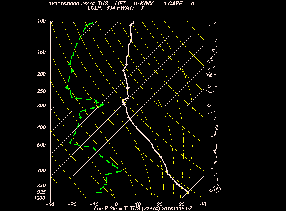
What kind of ice?
Probably needles and sheaths (aka, hollow columns), as likely was the type of ice in those clouds that barely precipitated, i. e., had the warmest tops, and produced fine veils of rain.
The heavier shafts suggested taller tops, colder than -10 C (14 F) with more complex ice crystals like stellars and dendrites form. All guesswork here, but hey, guessing is fun. The afternoon TUS sounding, which I just now looked at AFTER guessing, SEEMS to support these guesses.
In sum, yesterday was likely an unusual day for Arizona with ice forming in clouds with tops equal to or warmer than -10 C. This can really only happen when the clouds are especially loaded with water and are rather “clean” having lower droplet concentrations, both of which allow the formation of larger sizes of droplets in the clouds, which in turn, if you are still with me, leads to ice forming at higher temperatures than normal. The usual ice-forming temperature in AZ clouds is lower than -10 C since droplets are rarely very large in clouds here until they’re colder than -10 C. Well, that takes care of the last reader…..he’ll never be back.
The weather WAY ahead
The models continue to predict a longish spell of rain during the last ten days of September. In fact, the 18 Z WRF-GFS model run from yesterday had more rain in AZ than I have ever seen in a model output during that spell. Of course, as realistically weathermappy as these model outputs look, they are not too reliable, though this spell continues to be predicted in run and after run, as it has even with the latest (06 Z, 11 PM AST last night’s) run here.
From yesterday’s 18 z run, to fuel your imagination and hope, take a look at this output before they are overwritten by MeteoStar later today when the new 18 Z run is posted.
The End.