About real clouds, weather, cloud seeding and science autobio life stories by WMO consolation prize-winning meteorologist, Art Rangno
Author: Art Rangno
Retiree from a group specializing in airborne measurements of clouds and aerosols at the University of Washington (Cloud and Aerosol Research Group). The projects in which I participated were in many countries; from the Arctic to Brazil, from the Marshall Islands to South Africa.
Rarely do passing lows get a two chances to produce rain, but the low passing overhead today and tomorrow, does. Ten days from now, its overhead again! How funny izzat? And precipful, too.
Measurable rain will fall today in Catalina CDP (“Census Designated Place”, i.e., its not a city), and in about 10 days when the SAME low returns after a boomerang trip down Texico way, thence to Baja, thence to so Cal, and back over Arizona on the 10th-11th after picking up some juice over the east Pac.
Thinking, as you are now, of a minimum of 0.05 inches and top of 0.50 inches, the latter larger amount if projected afternoon thunderstorms land on us. Thus, best estimate, average of those two extremes, thinking Gaussian conceptual model modal value here, about 0.275 inches.
BTW, should be something in the way of an arcus cloud, or a batch of low scudding clouds underneath Cumulus and Cumulonimbus bases this afternoon as a windshift to the NW comes through in the afternoon or early evening hours, well in the next 18 h or so. That could be a dramatic sight, and with that windshift, the temperature will drop 5-10° F.
When the low trudges over us the second time around in mid-October, the estimated extreme amounts are a trace minimum, and 1.00 inch max, in other words, pretty clueless here about how much could fall the second time around ten days from now.
If you don’t believe me about all this, here are is the WRF-GFS prediction for this afternoon, followed by the WRF-GFS model prediction 10 days from now, today being October 6th, in case you don’t know what the date is today, maybe you’re retired and lose track of the days and dates because you don’t have a lot to do everyday, just kind of sit there:
5 PM AST, today, October 6th. Joe low goes by, heads toward Texas.5 AM AST, Friday, October 16th, the day before football day. Joe returns after visiting NM, TX, MEX, Baja, east Pac, then SC. Full cycle here, from IPS MeteoStar. Pretty humorous to watch this happen.
Yesterday’s clouds, punctuated by a large worm
6:57 AM. If you thought the clouds were fatter to the north most of the day yesterday, you were right. Many modest Cumulus passed overhead of Catalina and then fattened up to the north because the lifting mechanism aloft was stronger to the north of us. Quite a few moiuntainstations registered over an inch to the north of us.
However for a moment, we did have a shower threat move toward us from the south, this:
11:52 AM. Whilst on a hike up the Baby Jesus Trail, this appeared. Looked promising! But, vaporized into mere sprinkles. If you saw this, you almost immediately were thinking of ice forms like needles and sheaths, since the cloud was relatively shallow, and its still warm aloft. Needles and sheath (hollow columns) only form at temperatures above -10° C. Such an occurrence is rare in Arizona, so, quite an interesting bit of hand-waving here.10:57 AM. Hike up the Baby Jesus Trail was punctuated by seeing a very colorful worm of some kind. Not much else happened in weather or wildlife the rest of the way, Morning glory coverage was a little disappointing.4:17 PM. I am sure when you saw this Cumulus congestus that you, as I was, thinking you’d see a little ice emit out the right, aging and descending side of this cloud. In fact, no ice was visible. However, it was kind of neat to think how close we are now days in our cloud assessments, right or wrong.
The last data point is for 2014-15. These data are an amalgam of the Our Garden site on Pinto and Columbus, from the top of Wilds Road, and the last two years from Sutherland Heights.
OOPS. I was listening to a Southwest CLIMAS podcast, originating at the U of AZ, and realized I missed in the above graph what can only be termed an “ineffectual Niño” that which occurred in 1986-88 and did not produce a precipitation “signal” here. How lame was that?
So, while we are excited about the prospects of extra rain this winter due to the current, supersized El Niño, like all things weather, some doubt must be in place.
Rather than hiding the omission of the “ineffectual El Niño” period, I am inserting the corrected water year history plot here with slightly revised annotation so you can compare them both.
These data are mostly from Our Garden, 1977-78 through 2011-12, located at Columbus and Stallion. The data after that are from Sutherland Heights, Catalina, some 2 mi or so to the SE of that site, and about 300 feet higher in elevation. So there is a bit of what we would call a “heterogeneity” in the data.
The downward trend is misleading, since the Our Garden record began with extremely wet water years, due to a combination of a shift in the Pacific Decadal Oscillation that occurred in 1977-78 (a shift that squelched the then record West Coast drought) and a Niño or two.
That kind of downward trend shown for Catalina in cool season precip does not show up in the Statewide averages for the whole year, anyway, shown below.
Those annual data show the usual oscillations between drier and wetter epochs in Arizona. In the plot below, you can see that had the Catalina record started in 1950 or so, there would likely be little in the way of a trend since so many of those years were drier than average. You can also see the effect of the PDO change in the late 1970s where year after year was above for the State of Arizona as a whole.
The annual (Jan-Dec) state averaged rainfall for Arizona through 2014.
The weather ahead
Rain, tropical skywater, still appears headed our way around the 4-6th of October.
With these model outputs1 for early October. First, a tropical system barges into Arizona bringing copious rains:
Valid in only 10 days from now, sometime in October. Forget any rain chances in the rest of September. Temperature plummeting here now after hot night of foehn like wind from the north.
The exact same map shown above with annotation for helpless little weather babies that can’t see what’s going on.
But its gets even BETTER! In only two weeks, this tropical rampage:
A near hurricane strength tropical storm is about to smash into southern California/northern Baja bringing widespread rains to Cal and the whole SW, which once again, includes Arizony. Wow, wouldn’t that be something!
The End
———————————-
1These outputs, rendered by IPS MeteoStar, a great weather provider, are from the WRF-GFS model. You can’t find a better model than the WRF-GFS, unless you can access the European one (ECMWF), thought to have better “skill scores”.
So, combined with the giant El Niño in progress, which will spin off stronger tropical storms than usual (definitely), and the results of trillions of calculations from our best model that shows a lot of rain headed this way in TWO episodes in 10-15 days. The chances of this actually happening are way over 10%!
Spaghetti actually has a “weakness” in the upper level pattern that will allow that first system to creep toward us; not so much support for Hurricane “Giganta” that comes toward SC, or system number two.
Will get back to you when the drops start falling…
Might was well, since no rain will fall here through the end of September (ugh). Here it is:
The last data point, 18.33 inches, is for 2014-15. These data are an amalgam of the Our Garden site on Pinto and Columbus, from the top of Wilds Road, and the last two years from Sutherland Heights. Not much going on.
But lets look at a wider set of data to see what’s going on with the whole State of Arizona precip, through 2014, anyway. The plot below is the ANNUAL statewide average, January through December, the worst possible way to display 12 mos. of precip data. This is because it slices the cool season (October through May) in half, and whole cool seasons in particular can be impacted La Niñas and El Niños that usually only last one cool season. So those kinds of effects are muted in the presentation of annual averages in the plot below (from NOAA NCDC). Sure wish they would issue water year averages (October through September) or even the West Coast, July through June annual average; both of the latter two methods capture El Niños and La Niñas well.
The annual (Jan-Dec) state averaged rainfall for Arizona through 2014. You can see that lately we’ve been, as a State, drier than normal following the big wet years of the late 1970s and early 1990s, punctuated by the El Niños of 91-93 (a Pinatubo volcanic effect may be bound up with the early 90s wet spell, too). Its interesting to note that MOST of the years from the early 40s to late 70s were below average in ANNUAL statewide. Egad.
Gauge 15 1 3 6 24 Name Location ID# minutes hour hours hours hours —- —- —- —- —- —- —————– ——————— Catalina Area 1010 0.00 0.00 0.00 0.00 0.51 Golder Ranch Horseshoe Bend Rd in Saddlebrooke 1020 0.00 0.00 0.00 0.00 0.98 Oracle R S approximately 0.5 mi SW of Oracle 1040 0.00 0.00 0.00 0.00 0.83 Dodge Tank Edwin Rd 1.3 mi E of Lago Del Oro Pkw 1050 0.00 0.00 0.00 0.00 0.98 Cherry Spring approximately 1.5 mi W of Charouleau 1060 0.00 0.00 0.00 0.00 1.50 Pig Spring approximately 1.1 mi NE of Charouleau 1070 0.00 0.00 0.00 0.00 0.75 Cargodera Canyon NE corner of Catalina State Park 1080 0.00 0.00 0.00 0.00 0.55 CDO @ Rancho Solano CDO Wash NE of SaddleB 1100 0.00 0.00 0.00 0.00 0.63 CDO @ Golder Rd CDO Wash at Golder Ranch Rd
Santa Catalina Mountains 1030 0.00 0.00 0.00 0.04 2.56 Oracle Ridge Oracle Ridge, approximately 1.5 mi N of Rice Peak 1090 0.00 0.00 0.04 0.12 6.46 Mt. Lemmon 1110 0.00 0.00 0.00 0.00 1.73 CDO @ Coronado Camp CDO Wash 0.3 mi S of Coronado Camp 1130 0.00 0.00 0.00 0.00 2.05 Samaniego Peak Samaniego Peak on Sam Ridge 1140 0.00 0.00 0.00 0.00 4.92 Dan Saddle Dan Saddle on Oracle Ridge 2150 0.00 0.04 0.08 0.16 3.39 White Tail Catalina Hwy 0.8 mi W of Palisade RS 2280 0.00 0.00 0.00 0.08 3.82 Green Mountain 2290 0.04 0.04 0.04 0.08 2.05 Marshall Gulch Sabino Creek 0.6 mi SSE of Marshall Gulch
That seems like an appropriate description for Ms. Mt. Sara Lemmon after SIX inches of rain. Lemmon’s probably a little taller today than yesterday at this time, too. Should see the “glistening rocks” phenomenon now for a few weeks, as was the case after the several inches of rain at the end of last January. Will look to see if the Sutherland is flowing today.
Besides the stupendous amount of rain yesterday in the Catalinas, there were two other rare events.
1) an occurrence of the rarely seen cloud, Stratus (the cloud that resembles gray wall paper, not much going on inside it).
2) misty light rain and drizzle that fell from clouds having no ice (which means the tops could have been as cool as between -4 C to -10 C, nature’s highest ice-forming threshold temperatures in clouds, if you care.)
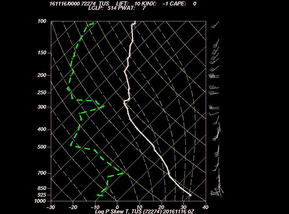
Below, the afternoon sounding, launched at Wildcat University at about 3:30 PM. Goes up at about a thousand feet a minute:
The TUS sounding for yesterday afternoon as rendered by the Cowboys of Wyoming.Same diagram, but with added value. Arrows point to region where tops were, rectangle highlights temperatures. With this diagram, called a “Skew-T”, you must tilt your head about 45 degrees to the left to get the correct view of the isotherms, those straight lines that in this view, slope upward to the right. The slightest drizzle that fell, likely fell from the warmest shallowest cloud tops, the heavier showers were deeper, likely extending to 0 C or slightly above.
Now, if you’re a real cloud maven person, you would have known that this was happening in Calalina/Oro Valley yesterday afternoon without looking at a sounding. It was the visibility reducing, fine, close together drops alternating between true drizzle1 When drops get bigger than that, we call those raindrops. But whose got a micrometer out there?
Much of the time the very lightest drizzle and rain fell on us without an indication of a radar echo, likely because the tops were below the beam from the radar site far to the SE of us. TEEVEE weathermen were flummoxed by this, reporting that rain was only falling in areas where there were echoes and that it wasn’t raining here. Woulda happened to me, making the big money on TEEVEE as a weatherman, too, had I not been here to observe this rare occurrence. But, instead I am here not making any money at all writing this. There must be a reason for it.
Now, what you’ve been waiting for, the shades of gray from yesterday:
Even those coupla of heavier showers later in the evening likely had no ice in them, though this is more of a guess based on the high concentration of raindrops smaller raindrops.
Next, let’s see if Hawai’i came to Arizona yesterday:
A couple of soundings from yesterday afternoon launched at Hilo and Lihue, HI.
In conclusion, based on nearly identical temperature and humidity profiles at TUS and in Hawai’i yesterday afternoon:
Hawai’i has come to Arizona!
There’ll be some more “climate substitution” today, too, before it all fades away into heat and dryness in the next coupla weeks.
Yes, your cloud day yesterday, starting with those STRANGE Stratus fractus clouds that churned and shot straight up the sides of Sam (Samaniego) Ridge just after the first bout of light rain. Estimating updrafts were something in the 10-20 kts straight up. Clueless about what exactly was causing that to happen, This phenomenon did not last long;
10:37 AM, after the lower air had been moistened by 0.09 inches of rain. No name for this strange sight, or maybe, Stratus floccus.OK, I’m talkin’ about that! Was shooting up like a rattler going for a horse’s belly. The higher cloud layer was Altostratus/Nimbostratus; you could use either name.10:37 AM also. More churning clouds over there.
After this, the intermittent light rain moved in again. If you don’t believe me that the rain was intermittent, here’s evidence from a tipping bucket record for the day, annotated for boredom after you questioned my statement:
Yesterday’s rain graph from a Davis Vantage Pro Plus Mark IV Extra Deluxe tipping bucket rain gauge in the Sutherland Heights area of Catalina, Arizona.
More clouds
11:29 AM. It starts raining again. Churning clouds briefly visible through cloud vault.2:23 PM. Looks like a view from Hilo to me except for the very different vegetation.4:25 PM. With southwest winds and lots of moisture, our familiar “crevice cloud” formed yesterday when the clouds lifted briefly showing how saturated air can be trapped in the lee of obstacles. When it occurs on a mountain top is called a “banner cloud.”5:15 PM. Stratus, a little ragged on the bottom, moves in and drizzle erupts along the Catalinas. A bird on a pole watches the drama.5:15 PM. In case you don’t believe me that there was a bird on a pole watching the drizzle drama unfold. I find I have to keep proving myself to my reader, even after all these years. Well, two years, anyway.5:56 PM. Finally, what you’ve been waiting for, as good an example of “pure Stratus” as has ever been seen, and it was right here in Catalina, Arizona, not along the northern California, Oregon or Washington coasts in summer where pure Stratus is usually seen every morning (if you’d like to see more Stratus, that’s where to go).
Wow, what a lot of information for you today! Hours of effort here! Well, maybe two. Maybe I could write a book about rain! Oops. Its already been done (“Rain2“). Cynthia Barnett, award winning science writer has just done it. That’s what happens when you procrastinate or don’t think of it in the first place.
Enjoy a last summer rain season day and those beautiful clouds we’ll have. Looks like drizzle/warm rain again on the mountains right now!
The End.
——————————-
1By definition, drizzle drops can’t be bigger than 500 microns in diameter, equivalent to about five human hairs; a fewer horse tail hairs. And, as you know from the many harangues on this subject, such small drops MUST be close together to be termed an occurrence of drizzle, as happened yesterday afternoon into the evening.
Had to come out of general hibernation to share this with you.From last night’s global data, this Canadian Global Environmental Model “solution”; a tropical storm center passes over Tucson!
Wow, what an interesting event that would be. Of course, wouldn’t be much of a wind thing, but could bring extra soaking rains with it. Size of font in figure below indicates level of personal excitement over this prediction.
As you know, good chances for significant rain have been predicted for most of AZ next week for a few days, but this would be a little icing on those predictions if we got a tropical low center passing over us.
Valid Monday afternoon. If this were too verify, there’d be a little wind with steady light to moderate rain over a period of hours, maybe would accum to an inch or two.
Cloud maven persons certainly saw this from the beginning; that scruff of something dark coming over the hills from the Avra Valley late yesterday afternoon. Here it is:
4:37 PM. Dark cloud cloud, smoke or dust, creeps over the hills SW of Marana. Didn’t know what it was myself, which is quite something in itself.4:48 PM Dark something now invading Oro Valley. Hills now obscured. Was thinking it was a grass fire since there had been no thunderstorm in the area upstream that might have produced outflow winds.5:22 PM. By this time is was apparent that this was a dust storm that had raced over the hills and into Oro Valley, on its way to Catalina, a very thin version of a ‘boob. Pretty amazing since there seemed to have been no storm to have produced it.
The rest of the story, as Paul Harvey used to say, was that the wind suddenly gushed in Catalina, estimated to 40 mph, briefly with a bit of haze due to this dust. A few drops of rain fell here from that layer cloud above that dust cloud a little later.
Nice little momentary and surprising splat of rain here last evening just after dark (about 7:30 PM). Radar showed just a little dot of rain when it happened. Drops were heavy enough for us to say, “What’s that?”, thinking it might be wind. Hardly lasted a minute.
Big LA rain yesterday morning!
A very surprising, heavy rain was in progress yesterday morning in southern Cal, Ventura County line southward into Baja, from the remains of tropical storm, Linda. Downtown LA got over 2 inches, as did numerous other sites. That would be about ten times the average September rainfall.
We seem to continue in the humid stream from Linda. Temp now 71 F, dewpoint 65! Very Hawaiian with Strato cu again topping Samaniego (Sam) Ridge. Likely to be a day similar to yesterday, kind of flat clouds on top of moderate Cumulus, with some tops protruding high enough to form ice.
Microphysics module
What kind of ice?
Probably needles and sheaths (aka, hollow columns), as likely was the type of ice in those clouds that barely precipitated, i. e., had the warmest tops, and produced fine veils of rain.
The heavier shafts suggested taller tops, colder than -10 C (14 F) with more complex ice crystals like stellars and dendrites form. All guesswork here, but hey, guessing is fun. The afternoon TUS sounding, which I just now looked at AFTER guessing, SEEMS to support these guesses.
In sum, yesterday was likely an unusual day for Arizona with ice forming in clouds with tops equal to or warmer than -10 C. This can really only happen when the clouds are especially loaded with water and are rather “clean” having lower droplet concentrations, both of which allow the formation of larger sizes of droplets in the clouds, which in turn, if you are still with me, leads to ice forming at higher temperatures than normal. The usual ice-forming temperature in AZ clouds is lower than -10 C since droplets are rarely very large in clouds here until they’re colder than -10 C. Well, that takes care of the last reader…..he’ll never be back.
The weather WAY ahead
The models continue to predict a longish spell of rain during the last ten days of September. In fact, the 18 Z WRF-GFS model run from yesterday had more rain in AZ than I have ever seen in a model output during that spell. Of course, as realistically weathermappy as these model outputs look, they are not too reliable, though this spell continues to be predicted in run and after run, as it has even with the latest (06 Z, 11 PM AST last night’s) run here.
From yesterday’s 18 z run, to fuel your imagination and hope, take a look at this output before they are overwritten by MeteoStar later today when the new 18 Z run is posted.
Along with this photo sequence, I reprise the thoughts you had as a CMJ1 yesterday as you watched a truly stunning cloud drama evolve:
6:01 PM. Huh. Kind of an isolated patch of dying Cumulus, transitioning to Stratocumulus (Strato, “flat”, Cumulus, “heap.” Huh. Flat heap? Kinda funny. A little late in the day for anything to happen, that’s for sure.6:16 PM. Well, that’s kind of rude. Must’ve heard my comment.6:24 PM. Hah-hah; that rude “finger” came off. But look, rain’s coming out! Wow! And a much fatter turret is emerging. How interesting! Very surprising this late in the day.6:26 PM. This is really getting interesting! More rain coming out, a whole series of turrets are emerging! How can this be? Hardly another cloud in the sky, they’ve all died away, but this one seems to be on Red Bull.6:34 PM. Good grief, can hardly believe how big this has gotten after looking like a dead bit cloud! When the rain is being released the cloud is no longer carrying all that weight and can spurt upward.6:36 PM. Bigger yet.6:39 PM. Truly magnificent. Since the main vertical riser does not show clear evidence of being fibrous, this would be call a Cumulonimbus calvus, “calvus” meaning bald. To the left was older cloud which did appear fibrous. In those cases, the cloud would be termed a Cb capillatus. Not a lot of lightning with this yesterday, so updrafts probably not extreme. Updrafts separate hail and smaller ice which provide electrification; no updraft to speak of, as in “flat” clouds, no electrification.
Nice morning, though, breezy, humid (dewpoint 65 F) with “flat heaps” (Stratocu) topping Sam Ridge now. What will happen today? Mods think some showers will form in the mid-afternoon here and there. But wind will keep the temperatures down, reduce chances of that.
Should be a pretty day regardless of what happens with the blue of the sky deepening each day as the sun recedes to the south farther each day.
Strangely, in the longer, unreliable term, the mods have been forecasting rain in AZ almost every day the last ten days of September, and this has been repeated for several runs. Huh#3.
The End; back to other work.
———————–
1CMJ– Cloud Maven Junior, our local club. No meeting this month.
For the second time this month, cloud-centric folk had a rare and happy sight: “naked” Nimbostratus, that is, the well-known mid-level1 precipitating cloud layer was present for all to see, but without the obscuring lower cloud decks normally associated with it, clouds like Stratocumulus or Stratus. Time and time again those pesky lower layers prevent one from seeing whose really producing the rain or snow at the ground because when precip is falling, its normally moist enough that lower clouds are present.
Those lower layers are important in enhancing precip because while they aren’t precipitating themselves (though it may seem like it) the drops falling into them from the Nimbostratus higher up, 1) won’t evaporate inside the cloud, and 2), if the droplets in the Stratocu are large enough, some of them will be collected by the raindrop falling through it and it becomes larger, the rain that bit heavier! How great is that?
Its really hard to compare how rare yesterday’s sight of “naked” Nimbostratus was yesterday, but offhand, I would say its about as rare as a professional wildlife photographer2 catching a shot of Cockrum’s Gray Shrew, aka, the “Hairy Packrat” or just “Harry Packrat”, shown below:
Oh, yeah, that Nimbostratus layer sans lower clouds….
12:37 PM. A layer of pure Nimbostratus produces very light, steady rain in Catalina. Cumulostratus3 clouds line the Catalinas below it.
Except for the rarity of the view, not much to see. The bottom is blurred by falling precip, and when its snow, where that snow melts into rain is perceived as the base of Nimbostratus. So…….in the warmer time of the year, “naked” Nimbostratus has a higher perceived “base” than in the cooler time of the year.
There was also another unusual situation, a cloud layer that really has no good name which I will now call from here on, “Cumulostratus.” See below:
12:07 PM. An example of the newly named cloud, “Cumulostratus.” Really there is no existing name that really hits this, maybe Stratocumulus castellanus.
2:07 PM. Kind of fun to see the hide and seek the “Cumulostratus” clouds were playing with Samaniego Ridge and Ms Mt Lemmon, too.
Not much immediately ahead in weather, oh, maybe some scattered showers later Sunday through Tuesday. Nothing really great jumps out of the spaghetti plots in the longer term.
The Canadian model thinks the newly formed desert lands of northern Cal all the way down to “Frisco” will get drenched, beginning in five days or so. That’s good. The USA model, using the same global obs at 5 PM AST yesterday, do not see that happening, but rather just some very light rains. Go Canada!
The End
———————————
1Probably doesn’t seem like Nimbostratus should be grouped with mid-level clouds like Altocumulus and Altostratus, but it is, strangely believe it, as I like to say. On synoptic weather maps it was placed above the station circle, indicating a mid-level or high cloud was present, as a “lazy F”, the character “F” lying on its back. Cloud types are no longer plotted on surface weather maps since today, clouds are mostly detected by machines, not humans. “Rise of the machines.” You know the story.
2The shot here forwarded to me with much excitement by pro photographer, Rick Bowers, of Bowers Photo, who had tried to photograph this vermin for about 20 years he reported.
3“Cumulostratus” is a name I made up because IMO there really is no satisfactory name for the cloud that lined the Catalinas/Samaniego Ridge yesterday.
BTW, a little more than 4.5 inches has fallen on Mt. Lemmon in the past 24 h. 0.99 inches fell here in Sutherland Heights. Maybe the Sutherland Wash will be running this morning. That would be nice to see.
More rains ahead in the next few days. Mushrooms coming…
Rain water balloon about to hit ground.Rain water balloon hitting ground, shoving other rain shaft aside.Cumulus tribute to Pac Man.Electricity.Plein air painting by nature.Ditto on the Catalinas.Dramatic shot, film noir maybe.Marana gets wet, too.Pretty.An approaching complex array of clouds just before sunset led to evening/nighttime TSTMS (weather text for “thunderstorms”). Often at this time of day, showers like this just fade away to just anvil debris. But not yesterday. Must have been, in this case, indicative of the approach of an upper level “congregator” or disturbance that doesn’t care so much about day or night.


![Desert-Shrew-or-Cockrum's-Gray-Shrew-0002[2]](https://cloud-maven.com/wp-content/uploads/2015/09/Desert-Shrew-or-Cockrums-Gray-Shrew-00022.jpg)