Our last hope for rain in early Feb; a thin blue line (a 552 decameter one)

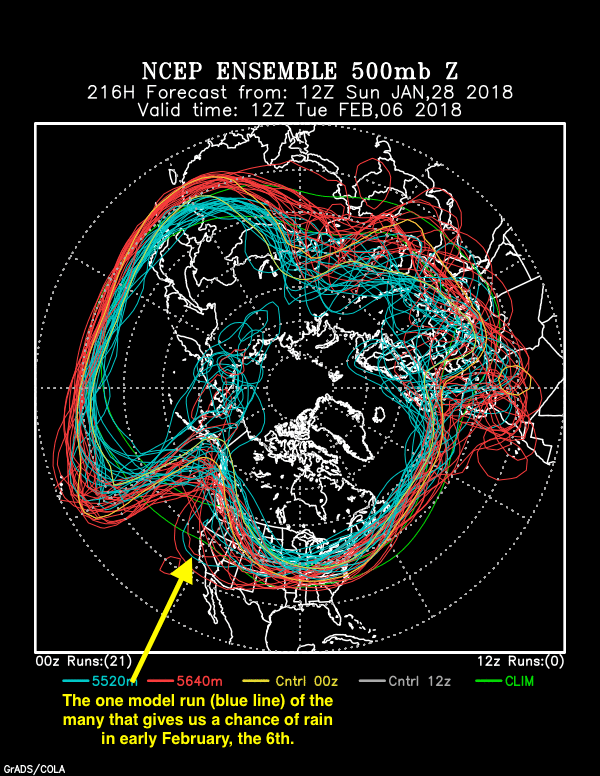
Blue, as in the 5520 meter height contour line as produced by a single run of the many NOAA GFS model re-runs with those little “perturbations” of the starting data.    Below, our only hope for rain here in Catalina is if the model run with a 552 decameter height contour over eastern Pacific across southern California (see arrow) verifies.  Its an outlier, a rogue, a voice in the wilderness, etc.

From the NOAA spaghetti factory based on the global data taken and perturbed at 5 PM AST last evening. The thin blue line to which the arrow points, would be a major, rain/snow producing trough. But since its an outlier from the other blue lines, representing the heart of the jet stream, its very unlikely to happen, even if it is produced by an actual model run for this date and time.

Some background and diversionary writing in excess; skip if busy

Now that we have more powerful computers, we can run the same model over and over again with very slightly different starting data and then see how the results diverge from one another in the days ahead.  In the first few days to week of the model run, the various outputs are virtually the same because the starting conditions are tweaked so very slightly.    This is chaos in action!  And it makes sense because we measure everything  perfectly  in the atmosphere at the same instant.  So, little errors abound in our starting data anyway.

Think of E. N. Lorenz,  “Dr. Chaos”!  In fact, he thought our existing atmosphere could shift into a pattern resulting in an ice age without any external forcing (oh, like an interstellar dust cloud coming by for a few thousand years, the sun dimming, etc.)

Pretty amazing thought when you think about it,  which you just have.

Nobody really thinks that today,  but he threw it out on the table in his seminole (haha) paper, “The Intransitive Atmosphere” back in 1967.  He also wrote about that kind of thing in the 1968 American Meteorological Society Monograph, “The Causes of Climatic Change“,  papers by 22 of the leading climate authorities of that time.  (Based on a 1965 conference at the National Center for Atmospheric Research, located in “Potville”, CO (aka, Boulder-haha.  But, they really do love their marijuana in Boulder…).

Strangely believe it,  in a further diversion from current weather and a mea culpa downstream that maybe you won’t get to with a lot boring writing before it:  not one paper in that AMS Monograph was about the climate effects of CO2!  Talk about being asleep at the wheel!  Wow.

Well, OK, you can’t blame them too much.

The earth’s temperature was slipping downward in those days, and while it was well-known that the effect of CO2 was to cause warming, it didn’t seem to be having enough effect to counter the cooling, and we were only just getting obs of CO2 from Mauna Loa.  Sure, its kind of an embarrassing chapter of science, so your not gonna hear much about it from scientists; the monograph above is almost never cited, or course.  We like to avoid mentioning embarrassing chapters.

I could name some others, in my specialty, like those cloud seeding experiments at Climax, CO, in the 1960s which looked so good, so complete, and fooled the National Academy of Sciences because it was really all “smoke and mirrors.”  Or those in Israel  in the 1960s and 1970s that fooled everyone for a long time, too, but, upon further review, were also “smoke and mirrors.”  Yes, that’s right, there was a “consensus” of scientific opinion about the results of each of those cloud seeding experiments that for a time  was wrong, as, to beat a dead horse,  happened in the early 1970s concerning the prospect of “global cooling;”  the preponderance of scientific thought was that an ice age was ahead (as indicated by a climate change conference at Brown University in 1972, the results  of which were summarized in Weather and Climate Modification, 1974, Wiley-Interscience publishers, W. N. Hess, Ed.   Hell, the earth was cooling, so it made sense at that time!

Pretty amazing when you think about it, which you just have.

We know better now.  CMP, like most everybody else, is predicting warming dead ahead, only how much is in question.

Here, we address embarrassing chapters head on, if anyone is still reading, which I hope they are not.   Check it out.

About 13 days ago, the NOAA spaghetti ensemble factory showed a result that strongly “IMI” (in my interpretation) indicated a vast weather change beginning at the end of January.  Sure, it was WAY out beyond what we consider to be a reliable forecast window, and unprofessional to make a forecast that far in advance, that is, much beyond a week, but the signal, the bunching of lines was so great, I went for it anyway.   I got excited and brought to your attention that a likely drought-interrupting weather change was to occur in 12-15 days from then, troughs would occupy the entire Southwest beginning at the end of January into the first week of February.

Its not gonna happen.

Cloud maven person was too confident in his interpretation of spaghetti back then, that a trough positioned in the SW  was virtually in cement;  it had to happen.   I was so excited and so wrong, got carried away, like I did with Sharon so many decades ago, thinking we were surely going to be a couple.   I was rongno then, too.  Arthur Rongno….  Oh, well, we learn and sort of move on.

Oh, there could still be a major trough toward the 5-6th of February, but as the title imputes, we’re down to a single blue, a rogue contour produced by one of the many model runs repeating forecasts  last evening with those little errors in starting conditions. the Lorenz model runs.  🙁 🙁  :{

The End, finally!

Learning from clouds, or lack of them; and the storm ahead

You probably should go here for your Sutherland Heights forecasts, brought to you by that great weather provider,  Weather Underground1.

Let’s begin with an exercise in excuses with this map from the Haight-Asbury District, aka, San Francisco State’s weather department, speaking of the 60s:

Map of the 500 millibar height contours (~18,000 feet above sea level pressure) for 5 PM AST yesterday when we were in the apex of a big trough with a minor pulse of curly air (vorticity maximum, to be provide some obscuration for layman, and for laywomen, for that matter) that was approaching.
Map of the 500 millibar height contours (~18,000 feet above sea level pressure) for 5 PM AST yesterday when we were in the apex of a big trough with a minor pulse of curly air (vorticity maximum, to provide some verbal obscuration for the layman, and for laywomen, for that matter) that was approaching.  That minor pulse , toward Vegas, was helping to produce a blob of clouds and light snow showers in the northern third of AZ yesterday.  The next storm is that bend in the contours.winds off SE Alaska.  Will drawn down cold air behind it across the whole US.  Some low temperature records likely to be set in the western US, though not here.

What is interesting to cloud maven person, in looking back retrospectively at yesterday, is that he has never seen a big trough like this that is SO DRY that not even the smallest of Cumulus clouds formed here in the area.  Not ONE!   It sky was so completely clear from horizon to horizon in the afternoon that it was truly astounding to CM.

Such a cloudcast humiliation (recall that C-M foretold of Cumulus that would develop and fill in, producing virga, and a few light showers in the area), of course, provides a learning opportunity, a chance to move forward, and as such, is truly WELCOMED by the persons working in science.     :{

So, we have seen the rare time when, with a 500 mb jet core south of us, that it does not circumscribe enough moisture for even a %#$! Cumulus fractus.  Therefore, we have seen that a jet core south of us is a necessary, but not a sufficient condition for precip in the area, something we learn every so often here.  (More than 95%, but not ALL, of the Nov-Apr precipitation at TUS falls with the 500 millibar jet core over or south of us.)

It is also evident that CM did NOT believe model runs that had little or no chance of precip and decent clouds around.  Very bad, a sign of unhumble thinking, possibly arrogance.

What’s ahead?

Well, as everyone knows, a major precip situation is building up for Catalinaland on December 31st through January 1st , as you saw from the Weather Underground’s forecast, one derived from our latest computer model run.  In  that you saw that a little SNOW is also forecast for here!  Nice, for a few hours afterward that is.  Get cameras ready.  Precip seems guaranteed here.   Bracketing amounts, should be at least 0.25 inches (things really go badly), and 1.5 inches as a top possibility.

The high end forecast by CM, whose recent diminished credibility should probably be taken into account,  is due to the possibility the main rainband in the system might stall for even just a few hours longer than currently forecast.  Typically, rainrates in the band are “moderate” here, technically defined as 0.10 to 0.30 inches per hour.  So, you can easily see that if the main rainband hangs on for just a bit longer than currently forecast, totals will climb rapidly.

And, this is a slow moving, major system by the time it gets here.  Exciting days ahead!

From two days ago, I thought I might fill in some of the photos from a Christmas Day hike into the Samaniego Ridge foothills that some reason WordPress had problems with:

DSC_1053
At the well-known watering hole called the Cement Trough.
DSC_1042
Water ran in every crossing of this tributary to the Sutherland Wash, on that hike on the Baby Jesus Trail though the wash itself was dry.
DSC_1058
A lady bug? Wow, completely unexpected on Christmas Day, 2014.
DSC_1047
Flowers like Desert Marigolds are still found blooming in some locations, though these are not them. I’d tell you what they were if I could remember, flower book loaned out.


The End


The End

—————————–

1They have nothing to do with the 1960s-70s radical folk with a similar name.


A rainy, drizzly Catalina day; 0.69 inches in The Heights

Yesterday’s cold front packed a few more rain “calories” than expected….  Kind of wrecked my play on beer in yesterday’s blog title as a way of making fun of it, you know, “Front light”.    See rain amounts below.

—————

But before that, a heads up:  1) More rain on way next week, at least a 100% chance of measurable rain during the week, and more storms after that (people will be complaining before long);

2) there are some pretty cloud photos at the very bottom in case you’d like to skip over a lotta verbiage;  quite dull writing, hand-waving, that kind of thing about what happened yesterday.

=============

Personal weather station totals as of 2 PM AST yesterday as rain ended.
Personal weather station totals as of 2 PM AST yesterday as rain ended from the Weather Underground map.  The green and yellow areas are radar echoes, yellow the stronger ones.

The official totals are pretty amazing, too, considering our best model was predicting something like 0.01 to 0.10 inches here in Catalina just before the rain started1.  Note below the 2.20 inches at Mt. Lemmon.  BTW, we’re now just about at our average rainfall total for December here in Catalina of 1.86 inches and we’ve gotten 1.85 inches so far.

Here’s a truncated rain table for our area from the Pima ALERT gauges (its a rolling archive and so you’d better get there early if you want to see the full lineup of totals for yesterday’s storm):

Pima County Regional Flood Control District ALERT System:  Precipitation Report
                              
              Precipitation Report for the following time periods ending at: 04:14:00  12/14/14
                       (data updated every 15 minutes)      
              Data is preliminary and unedited.
              —- indicates missing data
                          
    Gauge    15         1           3          6            24         Name                        Location
    ID#      minutes    hour        hours      hours        hours
    —-     —-       —-        —-       —-         —-       —————–            ———————
Catalina Area
    1010     0.00       0.00       0.00        0.00         0.51      Golder Ranch                 Horseshoe Bend Rd in Saddlebrooke
    1020     0.00       0.00       0.00        0.00         0.55      Oracle Ranger Stati          approximately 0.5 mi SW of Oracle
    1040     0.00       0.00       0.00        0.00         0.63      Dodge Tank                   Edwin Rd 1.3 mi E of Lago Del Oro Parkway
    1050     0.00       0.00       0.00        0.00         0.55      Cherry Spring                approximately 1.5 mi W of Charouleau Gap
    1060     0.00       0.00       0.00        0.00         0.75      Pig Spring                   approximately 1.1 mi NE of Charouleau Gap
    1070     0.00       0.00       0.00        0.00         0.67      Cargodera Canyon             NE corner of Catalina State Park
    1080     0.00       0.00       0.00        0.00         0.59      CDO @ Rancho Solano          Cañada Del Oro Wash NE of Saddlebrooke
    1100     0.00       0.00       0.00        0.00         0.43      CDO @ Golder Rd              Cañada Del Oro Wash at Golder Ranch Rd

Santa Catalina Mountains
    1030     0.00       0.00       0.00        0.00         0.47      Oracle Ridge                 Oracle Ridge, approximately 1.5 mi N of Rice Peak
    1090     0.00       0.00       0.00        0.00         2.20      Mt. Lemmon                   Mount Lemmon
    1110     0.00       0.00       0.00        0.00         0.55      CDO @ Coronado Camp          Cañada Del Oro Wash 0.3 mi S of Coronado Camp
    1130     0.00       0.00       0.00        0.00         0.79      Samaniego Peak               Samaniego Peak on Samaniego Ridge
    1140     0.00       0.00       0.00        0.00         0.71      Dan Saddle                   Dan Saddle on Oracle Ridge
    2150     0.00       0.00       0.00        0.00         1.34      White Tail                   Catalina Hwy 0.8 mi W of Palisade Ranger Station
    2280     0.00       0.00       0.00        0.00         0.59      Green Mountain               Green Mountain
    2290     0.00       0.00       0.00        0.00         0.98      Marshall Gulch               Sabino Creek 0.6 mi SSE of Marshall Gulch

Hell, there wasn’t any rain in the cloud band west of us when I got up, and so I thought with some lifting, and that jet core at 500 mb slipping southward from southern Cal as the day went on, rain would develop farther south in the frontal cloud band.  It did, of course, but still thought it would blow through in 2 h or so, something akin to the models as well.   The rain fell for about 5 and half hours!  The clearing took place a little before sunset, not in the early afternoon as expected.

So what happened?

I think you and I  overlooked a disturbance aloft behind the frontal band.  It was sliding SEwd fast from Nevada, catching up to our little frontal band. When those things happen, clouds magically seem to be appearing on the backside of the frontal band, fattening it up, holding its progress back; and the rain areas get bigger.  The frontal band was MUCH fatter when it went by TUS than it had been just a 100 or so miles to the west at 4 AM AST yesterday morning.  Here are contrasting satellite and radar images for two periods yesterday, before the band fattened up and the second, when it was raining so much here:

Satellite and radar imagery for 4:30 AM yesterday. Sneaky backside disturbance is represented by those clouds near Vegas.
Satellite and radar imagery for 4:30 AM yesterday. Sneaky backside disturbance is represented by those clouds near Vegas.  No rain echoes west of Catalina, stop along the Pima County line making it look like rain will be marginal here.
BY 1:30 PM in this satellite image with radar, the band is twice as wide and there's rain all the way down to Mexico way.
BY 1:30 PM in this satellite image with radar, the band is twice as wide and there’s rain almost all the way down to Mexico way.  Look how those clouds and showers near Vegas have caught up with our front, almost attaching themselves to it in north central Arizona.  Lots of times this process of upper air disturbances catching up to a front generates a cyclone along the front as the front widens and begins to kink.  I think that’s what happened anyway.  Whatever.  It was a great confluence of events for us here in Catalina.  Think how the wildflower seeds are feeling right now with already an average amount of rain for December, and its not half over, and more is on the way, yay!

If you’re a true C-M disciple you noticed something else yesterday:  true DRIZZLE in the rain.  Drizzle may be even more rare than snow here.  And the thick low visibility rain consisting of smallish drops from drizzle sizes, 200-500 microns (a couple to a few human hairs in diameter)  and raindrops just above those sizes for much of the time the rain fell,  should have made you start thinking of a warm rain process day.  Maybe there was no bright band in the radar imagery during those times, something that happens when rain is ONLY formed by colliding drops that get big enough to fall out; no ice nowhere.  In the heavier rains, sometimes when visibility was improved, ice was very likely involved.

The TUS sounding really can’t shed light on this question since the morning was had shallow clouds that weren’t raining yet, tops barely below freezing, and the 5 PM AST sounding, with tops at -10 C (14 F), was a little too late, though that layer that was sampled did produce what appeared to be ice virga in the direction of TUS about the time of the sounding.    BTW, its well known that “warm” rain processes that don’t involve ice occur at temperatures below freezing, so the expression is a bit of an oxymoron.

So, without radar imagery over us during the time of the thick rain and drizzle, we can’t say for sure, but it sure looked like it to C-M, which is  what you should think as well I think.  Thanks in advance for thinking what I think.

Enough of my excuses2, let’s rock and roll with yesterday’s clouds

Your cloud day

7:35 AM.  Light rain, looking suspiciously like "warm" rain, spreads over the Catalinas.  Its only gonna get better from here and frontal band barrels in on Catalina.
7:35 AM. Light rain, looking suspiciously like “warm” rain, clouds not looking so deep, spreads over the Catalinas. Its only gonna get better from here as frontal band leading edge is just across the street over there on the Tortolitas.


8:09 AM.  "Oh, what a crummy front, things breaking up already", you were thinking.  Also, "Look at how shallow those clouds are!  Terrible."  Sometimes these brief thin spots or clearings are called, "sucker holes."
8:09 AM. “Oh, what a crummy front, things breaking up already”, you were thinking. Also, “Look at how shallow those clouds are! Terrible.” Sometimes these brief thin spots or clearings are called, “sucker holes.”  Hope you didn’t fall for it like I did.  (Just kidding.)
9:43 AM.  R--F (text for "very light rain and fog"), rain has piled up to 0.10 inches.  But you notice there's something different about the rain, its thicker, smaller drops, even drizzle drops in it.  You begin ask, "Could this be a solely warm rain event?"  I think so.
9:43 AM.  W0X1/2 R–F (text for “indefinite ceiling,  zero, sky obscured, visibility 1/2 statute mile in very light rain and fog”), rain has piled up to 0.10 inches by this time. But you notice there’s something different about the rain; , its thicker, small thick drops hardly making a splash in puddles, even drizzle drops in it. You begin ask, “Could this be a solely warm rain event?” I think so. Note disappearing telephone poles.
12:46 PM.  After several hours of rain, flood waters begin to appear.  Note mottled surface of this lake, showing that the drops were making good splashes at this time.  Rain intensity deemed R (moderate) then.
12:46 PM. After several hours of rain, flood waters begin to appear. Note mottled surface of this small rain-formed lake, showing that the drops were making good splashes at this time. Rain intensity deemed R (moderate) then.  Deemed not a warm process rain at this time due to those drop sizes and less bunching, fewer small drops in between the larger ones, visibility was about 2 miles in rain.

The best scenes of all were when the clouds began to part in the late afternoon and evening sun.  I hope you caught these beautiful scenes:

DSC_0405 DSC_0403 DSC_0387 DSC_0377

The End

—————————————————–
1Total rain prediction from our best model, the one from the U of AZ with the predicted totals through 3 PM AST yesterday. The model run was at 11 PM AST the evening just before the rain began:

Ann RaIN THROUGH 3 PM 12-13
The arrow points to our location, in which only a tiny amount of rain was predicted. Mod doesn’t miss very often by this much, but the earlier December storm had the same mod problem, too little in the model compared to what actually fell here. Gee, new thought… Could it be a poor representation of the warm rain process? Hmmmm.


2Your Catalina C-M did have a correct range of amounts that could fall in yesterday’s storm right up until the last minute.  For weeks he was predicting, and staying firm with, 0.15 inches on the bottom, and a voluptuous, if that’s the right word, 0.80 inches potential on the top.


O, models, disappoint

Odile passed to the S and E of Cat land, leaving only 0.13 inches here in the Heights, the Sutherland ones.  Didn’t even get the half inch I hoped for.  Oh, well, we can be happy for the droughty areas of New Mexico that got the brunt of that tropical system as did portions of extreme SE AZ.  You may know that for many days in advance and up until 11 PM the night before last (shown here), our best models had O practically passing right over us with prodigious rains indicated.

Unfortunately, we meteorologists often “go down with the ship” when this happens due to model forecast consistency.  Only in the last minutes, so to speak, did the model runs get it right (but too late to be of much use) and finally indicated that the true path of the heaviest rain was NOT going to be over us, as was already being discovered via obs.  O was such a cloud mess, the mods may have been off in locating where the center was.  Not sure.  Will have to wait for the panel report.

Seems to be preciping on the Cat Mountains right now, though doesn’t show up on radar, so its likely a RARE “warm rain” event here in AZ where the rain forms by collisions between larger cloud drops to form rain drops and the cloud tops are low1.  Maybe that’s O’s legacy;  tropical air and a warm rain day sighting.

BTW, whilst Catalina and most of Tucson didn’t get much, it has continued to rain steadily in our mountains over the past 24 h with Dan Saddle, up there in the CDO watershed, leading the way with 2.09 inches in 24 at this hour (5 AM) and its still coming down lightly, as noted.  Its been a fantastic rain since it was steady and soaking up there over that whole 24 h period, much like in our winter storms.  Below, some totals from the PIma County ALERT gauges.  You can see more totals here.

Gauge    15         1           3          6            24         Name                        Location
    ID#      minutes    hour        hours      hours        hours
    —-     —-       —-        —-       —-         —-       —————–            ———————
Catalina Area
    1010     0.00       0.00       0.00        0.00         0.16      Golder Ranch                 Horseshoe Bend Rd in Saddlebrooke
    1020     0.00       0.04       0.04        0.04         0.20      Oracle Ranger Stati          approximately 0.5 mi SW of Oracle
    1040     0.00       0.00       0.00        0.00         0.12      Dodge Tank                   Edwin Rd 1.3 mi E of Lago Del Oro Parkway
    1050     0.00       0.00       0.00        0.00         0.16      Cherry Spring                approximately 1.5 mi W of Charouleau Gap
    1060     0.00       0.00       0.00        0.00         0.16      Pig Spring                   approximately 1.1 mi NE of Charouleau Gap
    1070     0.00       0.00       0.00        0.00         0.04      Cargodera Canyon             NE corner of Catalina State Park
    1080     0.00       0.00       0.00        0.00         0.20      CDO @ Rancho Solano          Cañada Del Oro Wash NE of Saddlebrooke
    1100     0.00       0.00       0.00        0.00         0.08      CDO @ Golder Rd              Cañada Del Oro Wash at Golder Ranch Rd

Santa Catalina Mountains
    1030     0.00       0.04       0.04        0.08         1.73      Oracle Ridge                 Oracle Ridge, approximately 1.5 mi N of Rice Peak
    1090     0.00       0.00       0.04        0.04         0.75      Mt. Lemmon                   Mount Lemmon
    1110     0.00       0.00       0.00        0.00         0.43      CDO @ Coronado Camp          Cañada Del Oro Wash 0.3 mi S of Coronado Camp
    1130     0.00       0.04       0.04        0.04         0.31      Samaniego Peak               Samaniego Peak on Samaniego Ridge
    1140     0.00       0.08       0.28        0.35         2.09      Dan Saddle                   Dan Saddle on Oracle Ridge
    2150     0.00       0.00       0.04        0.08         0.71      White Tail                   Catalina Hwy 0.8 mi W of Palisade Ranger Station
    2280     0.00       0.04       0.12        0.16         1.02      Green Mountain               Green Mountain
    2290     0.00       0.04       0.04        0.04         0.47      Marshall Gulch               Sabino Creek 0.6 mi SSE of Marshall Gulch

BTW#2, true CMJs (cloud maven juniors) will want to photograph the rain from these shallow clouds, this rare, Hawaiian-like rain event2,  lining the Catalinas this morning as soon as its light enough.   It would be like photographing a parakeet on your bird feeder here in Catalina, one migrating from South America.  I think that’s where they come from.  Anyway, your cloud-centric friends from other part of the world would be quite interested in seeing your photos of this.

Is the summer rain season over?

No way!   (But you already knew that, though it sounds more exciting to put it that way, in the form of a question like the TEEVEE people do)

Now we get into some interesting weather times as we go back into the scattered big thunderstorms feeding on the moist plume that accompanied O.   That moist plume will be around for the next few days.  These coming days, with their thunder squalls,  may well be the most “productive” ones for rain here compared to the piddly output of O here in the Heights.  We have upper air goings on that are likely to make storms cluster more into big systems a time or two during the next few days instead just the one over here and over there kind of days, the ones you hope you get lucky on to get truly shafted.  So, “fun times at Catalina High” ahead, to paraphrase something.

 Yesterday’s clouds

11:15 AM.  The look of a stormy sky, Stratus fractus lining Samaniego Ridge, overcast Nimbostratus producing R-- (very light rain).
11:15 AM. The look of a stormy sky:  Stratus fractus lining Samaniego Ridge, orogrpahic Stratocumulus topping the Ridge, overcast Nimbostratus producing R– (very light rain).
DSC_0132
4:56 PM. By afternoon the deeper clouds were gone leaving Cumulus, a couple of distant Cumulonimbus clouds with their rain shafts, and an overcast of Stratocumulus or Altocumulus, no precip coming out of them.
DSC_0135
6:28 PM. The sunset, while OK, like O was a little disappointing since more clouds could have been lit up by the setting sun but weren’t.

 The weather way ahead

Cool weather alert:  based on model consistency, which I have already discredited earlier, there are cold snaps now appearing for the end of September and early October. They’ve shown up in a couple of runs now.   They have some support in the NOAA spaghetti factory plots.


The End.

—————————–

1There’s a nice description of  “coalision” , the warm rain process not involving ice, in Pruppacher and Klett (1998) if you really want a nice book about cloud microphysics in your library.

2Mostof the rain that falls in Hawaii falls from relatively shallow clouds with tops at temperatures above freezing, no ice involved, contrary to the usual situation here where ice is necessary.

Snowbirds may head back to Arizona as low temperature records fall in the eastern US in a few days

Forgetting about yesterday’s unforecast subdued afternoon convection hereabouts after about 1 PM), lets talk about the misery of others; the little crybabies that leave Arizona in the summertime, decimating its economy, so that they can be cooler and “happy” in northern climes (while dodging hail and tornadoes, we might add).

Well, how about them birdies being really COLD before very long, due to record breaking low July temperatures?  Yes, that’s right, what’s left of the “polar vortex” will once again, due to global warming, of course, spin out of control and down into the northern US in just about 5-7 days.   And with it, long term July low temperature records will fall in the eastern US. Count on it.

So, once again, as some scientists alleged last winter,  global warming will actually cause cooling.  (Almost everything that happens is due to GW these days, as we know. (“GW”, BTW,  now repackaged in the catch all, temperature-neutral phrase, “Climate Change”,  during the past few years because, globally, it stopped getting warmer way back in ’98, and when the years began to pile up without global warming, scientists had to find another phrase to hang their mistaken hats on.  (Where was the usual scientific “caution” back then?)

HOWEVER, continuing on with this harangue, and being a “lukewarmer”,  we must watch out that the coming big El Nino doesn’t release a spring-loaded,  pent up release of global heat.  Might well happen, so don’t give up on “GW” quite yet; hold some cards on that question for another few years.

And, of course, if there is a step jump up in global temperatures just ahead, the phrase, “climate change” will be dumped by scientists and media for “global warming” again.  Count on it, #2.

But, I digress, mightily, mainly due to yesterday’s cloud disappointments.

—————————-

Not in a great mood after yesterday’s bust, as you can tell, except for that strong thunderstorm that pummeled the north side of the Catalinas beginning about 11:30 AM, that was pretty cool; had continuous thunder for about an hour and a half, too. Dan Saddle up on Oracle Ridge got 0.63 inches, but you can bet 1-2 inches fell somewhere up there.

I was so happy then.

I thought the “Great Ones” would arise upwind of us in the direction of Pusch Ridge, but no.  Those clouds got SMALLER as the afternoon wore on, it was incredible, and by sunset they were gone with only trashy debris clouds of Altocumulus and Altostratus cumulonimbogenitus from great storms in Mexico drifting over our sky.  Even the sunset was disappointing.

Well, that 3:15 am to 3:30 am little shower this morning than dropped 0.15 inches here in the Heights, and 0.24 inches down there at the Bridge by Lago del Oro gave a psych boost1 that got me here on the keyboard.

10:55 AM.  Nearly invisible veil of ice crystals begin to fall from an older Cumulus congestus turret.  This was about an hour and a half ealier than the prior day, indicating that the Cu tops were reaching that level sooner than the prior day, suggesting bigger things (I thought).  When you see this happening this early, you also look for an "explosion" some massive turret to suddenly blast out of these developing clouds, and that did happen within about half an hour after this.
10:55 AM. Nearly invisible veil of ice crystals begin to fall from an older Cumulus congestus turret. This was about an hour and a half ealier than the prior day, indicating that the Cu tops were reaching that level sooner than the prior day, suggesting bigger things (I thought). When you see this happening this early, you also look for an “explosion” some massive turret to suddenly blast out of these developing clouds, and that did happen within about half an hour after this.


10:55 AM.  Close up, in case you don't believe me.
10:55 AM. Close up, in case you don’t believe me.


11:04 AM.
11:04 AM.


7:33 PM.  Your sunset.
7:33 PM. Your sunset.

Today?  Check here.  Once again, mod expects early Cumulonimbus on The Lemmon, then groups of thunderstorms move in during the evening (as was more or less predicted yesterday, but didn’t happen.)  Will go with mod again, though, because I would like that to happen.

The weather way ahead

We’ve talked about cold air, now to balance things off, how about a discussion of the warm air ahead?  Real hot air.

Was blown away by the spaghetti outputs from last night for the period of about two weeks from now.  You can see the whole package from the NOAA spaghetti factory here. Below, our weather in 12-15 days, usually beyond confident predictions, but not here:

201407221700 spag_f288_nhbg

Valid at 5 PM AST July 22nd. Massive blob of really hot air settles in over the western half of the US.  In this map, the most reliable long term predictions are over the western half of the US and over the Saharan Desert (indicated by the lack of lines in those two areas.  A lot of lines means the weather pattern is pretty unpredictable.)


Valid at 5 PM July 22nd.  Massive upper level blob of really hot air sits over the entire West!
Valid at 5 PM July 25th. Massive upper level blob of really hot air continues to dominate the western half of the US.

&


So


The hot blob of air should lead to record HIGH temperatures all over the place in those days beginning around the 20-25th of July.  Rainfall here?  Indeterminant.  If the high center sits over us, it might just be hot, real hot, but dry.

But, if the configuration aloft is as shown in the second plot, it could be very wet as tropical disturbances shift northwestward from Mexico into Arizona.

Sorry, can’t do much with precip from these,  I don’t think.

The End, and covering all the possibilities, CM

====================================
1Paraphrasing, the song for weathermen, those speaking to clouds; “Rain on me, when I’m downhearted….”

A last WY rain adds to total; 0.17 inches in violent, short-lived morning storm

Our WY total has crested over 11 inches now.  Its at 11.08 inches for the water year ending on September 30th, still about 5.5 inches below normal with only dry days ahead.  Still it was nice to see a great thundersquall come through on the last day of the summer regime, though I was about 12 miles away from Catalina when it hit.  So, I missed the last summer-type rain of the season with its momentary blinding rain and 40 mph winds; I had to be told about it.  That season will be just a memory now.

If you’re a reader of this blog, and I know who both of you are, you MAY recall that yesterday, off-handedly really, it was written here that, “I don’t think it will rain today.”  But it did rain, which is pretty remarkable in itself.  It has previously seemed that if I think or say something, that’s what happens, almost like  a supernatural connection of some kind with the future.  Some of the astrologers out there know what I am talking about, maybe palm readers, too.

I will go through what happened just that bit, well, quite a bit, while I display some photos and our thinking was about what we were seeing. I know that our thinking would be exactly the same since you read this so much.

Now, when I started yesterday morning on this blog, the dewpoints were very high around here, 60s, and there was a little line of clouds in the satellite imagery on our doorstep to the west.  Part of that north-south oriented cloud line is what you saw when you got up yesterday morning.

However, the dry air was already into central Arizona, with dewpoints in the 40s at PHX and Yuma; it was coming fast as the trough above scooted over us dragging a cool front.  Behind the cool front would be the dry air.

So what are you and me looking for when we think an LL Cool Front is approaching, along with its wind shift?

A line of clouds, solid, broken or even scattered.  So, when you saw that line of heavy Cumulus piling up in a line, SW to NW from Catalina, you and me were both thinking, “Droop, there it is!1“, to recall a song first heard on the TEEVEE show, “In Living Color.”

8:26 AM.  Front on the doorstep or not.
8:26 AM. Front on the doorstep or not.  Looking west toward the Tortolitas.  Even though the clouds are piled high, notice that there are NO rain shafts.  No ice, and even with the warm bases at about 10 C (50 F), rain from drop collisions with each other also did not form.  See smog shots later; smog is an impediment to that process.


8:24 AM.  Heavy Cu line extends off to the N as well, strongly suggesting a wind shift is causing it.
8:24 AM. Heavy Cu line extends off to the N as well, strongly suggesting a wind shift is causing it.  Again, no rain shafts are seen from these large clouds.
8:20 AM.  While the sights to the west were promising, the amount of smog (not dust here) was deafening.  Sure there were pretty highlights as the crepuscular rays focused on our still green mountains, but still, its not a good sign for precip; works against it.
8:20 AM. While the sights to the west were promising, the amount of smog (not dust here) was deafening. Sure there were pretty highlights as the crepuscular rays focused on our still green mountains, but still, its not a good sign for precip; works against it by causing the drops in clouds to be smaller than they would be in “clean” conditions.
8:38 AM.  Eventually those tops did reach ice-forming levels, those likely colder than -5 to -10 C yesterday, and rain shafts began to emerge, as here.  But, that was off to the north beyond SBrooke, and the clouds to the SW of us were turning ragged, drying out.
8:38 AM. Eventually those tops did reach ice-forming levels, those likely colder than -5 to -10 C yesterday, and rain shafts began to emerge, as here. But, that was off to the north beyond S-Brooke, and the clouds to the SW of us were turning ragged, drying out.
9:06 AM.  By 9 AM, any hope for rain here had seemingly vanished as the clear signs of dry air moving in, along with subsidence aloft were clear.  It hadn't rained, and though I always hope it will, I was amazed at how my risky forecast of no rain had magically occurred, leading to a slight case of megalomania, grandiosity, if you will.  It was though I had spoken those smoggy clouds directly.  It was finished.  I now thought I might as well leave and go on some errands; not chance of rain now!
9:06 AM. By 9 AM, any hope for rain here had seemingly vanished as the clear signs of dry air moving in, along with subsidence aloft,  were now clear to you and me. It hadn’t rained, and though I always hope it will, I was amazed at how my risky forecast of “no rain” had magically occurred, leading to a slight case of megalomania, grandiosity, if you will. It was though I had spoken to those smoggy clouds directly. It was finished. I  thought I might as well leave and go on some errands; no chance of rain now!  I also think of myself as kind of a Garrison Keillor of clouds, tellling stories about them, and continuing a megalomaniacal theme here.   “I try to tell the truth”, Garrison once said, then continuing,  “but the truth doesn’t always take you as far as you need to go.”
SONY DSC
9:03 AM. Looking NW. Those huge clouds of just a few minutes earlier are gone, and now only suppressed versions of Cu are seen.

Then, the transformation back to what we had just seen earlier that morning!  It was amazing, with HUGE Cumulonimbus clouds arising from the same appearing line of heavy Cu.  Here we go into “error”, and I would add, humility:

9:49 AM.  Was in route to Marana.  Though these Cu had fattened up from nothing, thought they would be dessicated by the dry air moving in, would ragged and shredded looking in the middle and upper portions.
9:49 AM. Was in route to Marana at this time from SH, but stopped to take a photo. Though these Cu had fattened up from nothing, thought they would be dessicated by the dry air moving in, that is, would look ragged and shredded and not amount to anything.
10:14 AM.  WHAT?  A shocking view, this Cb and rain shaft, upwind of Catalina.  I had to keep going to finish an errand though, not race back and enjoy what MIGHT be the last storm of the summer rain season.
10:14 AM. What?  This was a shocking view, this Cb and rain shaft, upwind of Catalina. I still had to keep going to finish an errand though; not race back and enjoy what could be the last storm of the summer rain season.
11:15 AM.  Your storm, about to strike.  Those clouds on this side of the giant, mounding Cb were the ones that done it, ones that exploded upward a few minutes later.
11:15 AM. Your storm, about to strike. Those clouds on this side of the giant, mounding Cb were the ones that done it, ones that exploded upward a few minutes later.  Fortunately, I got some first hand reports from neighbors and used some imagination to experience how bad it was for a few minutes.
11:57 AM.  Just back in SH country, and the showers are still around, here to the NW.
11:57 AM. Just back in SH country, and the showers are still around, here to the NW.
11:58 AM.  But this view to the SW and upwind, is really The End, its over, it is finished, etc.  The summer rain season has ended for us.  The dry is moving in now, the clouds will wither and die even as the afternoon warms up some.
11:58 AM. But this view to the SW and upwind, is really The End, its over, it is finished, etc. The summer rain season has ended for us. The dry is moving in now, the clouds will wither and die even as the afternoon warms up some.


The only weather ahead now for the next couple of weeks is temperature changes.  That’s about it, so will take a little break here, maybe only post once in awhile, and more on climo or science stuff.

The End.


—————————
1Modified for baseball to, “Bloop, der it is!”. A “bloop” is a weakly hit ball that falls for a base hit.

Distractions from disappointments; so many yesterday

Thought maybe a nice distraction from yesterday’s rain disappointment would be looking at some file boxes from the University of Washington’s Atmos. Sci. basement.  This shot taken a couple of days ago.

Enjoy thinking about what might be in these boxes, and what you would do with the contents.  Have some extra coffee, talk it over with friends, think about how much you might offer if one of these boxes was something on a quiz show, and you had one thing you knew what it was, but had to take your chances on what might be in one of these boxes1?  Or if saw them in storage locker you were bidding on.  How much?  Lots of possibilities to think about.

Taken a couple of days ago.  They have stuff in them, unlike our clouds of late.

———weather part——

You started to get a bad feeling about yesterday, in spite of the juicy clouds on Samaniego Ridge, bases around 15 C, extremely warm for AZ, meaning full of extra condensed water compared to our normal clouds, when the north wind began to blow, and the temperature was struggling to go beyond 80 F.

Usually, when the cloud bases are low, it doesn’t take a LOT of heating to power them up into Cumulonimbus (Cbs) clouds because the condensation itself releases heat.  But struggling to reach 82-83 F here was just too little heat.

Late in the afternoon we did have a nice, if weak, Cb on the Cat Mountains (no thunder, of course, it was that weak).   They did get half an inch on top of Mt. Lemmon and a couple of other places, so at least SOME rain fell near us.

And, not only did we have the “juice”, high amounts of water in the atmosphere over us, but also a nice cyclonic swirl passed overhead yesterday, too, something we normally look to cluster Cumulonimbus clouds into large groupings with major rains.  From the U  of WA, you can see it go by here.

To finish off thoughts of yesterday, some mood music to go along with those thoughts, I would like you to now hear covers of “pretty songs” by the Circle Jerks.

—————————-

Here are your clouds from yesterday, I know you’ll want to see them again, mope around some more about what could have been.  We will begin our review of yesterday’s clouds with today’s morning rainbows:

6:00 AM.
6:00 AM.  Sloping rain shaft tells you that the drops are very large, rain not too heavy.
6:02 AM.  Bow over the Oro.
6:02 AM. Bow over the Oro.
11:03 AM.  Those oh so promising Cumulus congestus clouds lining the Catalinas!
11:03 AM. Those oh so promising Cumulus congestus clouds lining the Catalinas!
4:19 PM.  Finally a Cumulus congestus that looked like it would exit the juvenile stage and mature into an adult (Cumulonimbus).
4:19 PM. Finally a Cumulus congestus that looked like it would exit the juvenile stage and mature into an adult (Cumulonimbus).
4:36 PM.  And it did grow up.  This is what produced the half inch on Ms. Lemmon.
4:36 PM. And it did grow up. This is what produced the half inch on Ms. Lemmon.


No real chance of rain now for a few days. Oh, me.

The End.


———-

STAR WARS AND rEAGAN
From 30 years ago or so…. Wonder what historians would say now?

1Example of a quiz show where you bit on a mystery box if you want, or take the thing that’s offered in front of you.

Water, water everywhere in the sky, but not much fell on the ground

Yesterday was a disappointment.  Oodles of water up there above us, as represented by cloud bases somewhere around 15 Celsius  (59 F) yesterday morning, early Cumulonimbus activity–one was up toward Oracle by 10:37 AM–Oracle got 1.06 inches yesterday, but while the skies darkened over Catalina several times, they didn’t “unload.”  Maybe only once or twice before in six summers have I seen this darkening to the level we had yesterday, without a rain shaft soon falling out of it.  A couple of examples from yesterday:

1:29 PM.  A Cumulus congestus takes shape over Cat State Park, and heads toward Catalina.
1:29 PM. A Cumulus congestus takes shape over Cat State Park, and heads toward Catalina.  Only sprinkles fell.
2:40 PM, looking toward Charoleau Gap.  It doesn't get more "portenful" than this. I was SURE a shaft would crash down, and with it, the WIND from the north, the clouds then building over ME to the south, as happens so often when heavy rains pour down on the Gap.  Didn't happen, at least not until too late, long after it had moved farther north.
2:40 PM, looking toward Charoleau Gap. It doesn’t get more “portenful” than this. I was SURE a shaft would crash down, and with it, the WIND from the north, the clouds then building over ME to the south, as happens so often when heavy rains pour down on the Gap. Didn’t happen, at least not until too late, long after it had moved farther north. Got pretty dejected.

So, what went wrong?  Why were the clouds SO DARK, even shallow ones like Stratocumulus, let alone the Cumulus congestus, but with so little “emitting power”?

The darkness of these clouds was surely due to the high smoky aerosol content of the air that led to unusually high droplet concentrations in these clouds.   The higher the droplet concentrations, the darker the bottom of the cloud, say holding cloud depth constant.  So, a moderately deep cloud, but one too shallow to rain, can look like these, like the normal darkness on the bottom from which blinding shafts of rain fall.  So, most likely we were looking at smog-laden clouds, the kinds of ones in our future around the world because that’s what we do, produce smog and smoke, well, us and lightning.

And, as we recall from Squires and Twomey (1967), smoke inhibits the formation of rain in clouds. I am sure most of you remember that article about smoke and sugar cane fires in Australia, and how those smoked up clouds did not rain like the ones around them that were “clean.”  This phenomenon has been reported on numerous occasions since, like how in LA it helps reduce drizzle (mist rain) occurrences.

However, as we know, even smoked up clouds can rain IF they get high enough to reach the -10 C level here because then copious amounts of ice, soft hail and snow will form aloft, and down it will come!  That only happened in isolated places, like over Oracle where they got that inch of rain (at least around here).  So another cause of dark clouds lacking in downspouts was that they were not QUITE deep enough for the tops to reach -10 C. up around 20,000 feet above the ground yesterday–those tops were SURELY so close, though!

Back to smoke effects.  With bases as warm as 10-15 C yesterday, there should have been rain formed without ice, and almost certainly a little did (these eyeballs detected some yesterday afternoon on the Catalinas).  However, this is the type of rain that smoke inhibits most.  This is because with so many cloud droplets competing for a given amount of condensation, they all stay too small to  collide and stick together (requires drops bigger than 30 micrometers in diameter (let us not forget Hocking and Jonas (1970)….  So, we lost some rain due to smoky skies there, too,

Next, it can be relatively cool with tremendous amounts of rain IF there is a good disturbance to cluster the clouds together, forcing converging air near the ground, taking it away at Cirrus levels.  We didn’t have a “disturbance”, a trough or a low to help out.

Finally, without the help aloft, we needed, as you can all guess by now, that bit more heating at the ground, maybe just a few degrees was all to launch some really large but isolated storms.

Today?

U of AZ 11 PM mod run has Cbs developing over the Catalinas by noon, and during the afternoon some of those showers trail to the northwest over Catalina.  I think one will.   So, once again we have a day with rain around, and maybe today a little cell will bombard us with a quarter of an inch.  Should be warmer, today and that will help since again we have no trough help.  Still smoky, as you can see here at sunrise by that orange-brown layer below this morning’s Cirrus.  So, once again, the clouds may look a bit darker than they “should” when we have clean air.

The End except for this nice morning shot of Ac perlucidus undulatus I would call it.  Very nice!

6:54 AM.  Altocumulus perlucidus undulatus, if you care.
6:54 AM. Altocumulus perlucidus undulatus, if you care.


Clouds go round and round with a sprinkle-rain landing close by last night

One of the things I like to do when I am wrong, yesterday having predicted a trace to a few hundredths of rain last night from that disturbance going by to the south, is to spend a LOT of time talking about how close I was.

Its true the zuperkomputer, the Beowulf Cluster, at our U of AZ Weather Department, did NOT predict rain here at all, but it did not have the sprinkles as close as they came to us, either!  Exulting here that bit.  Going to look on “trace detector” (car parked in dust and sun outside) now, just in case there is a drop image somewhere.  Will report back on that later.  Stand by.

Also, you should be looking around for drop images in the dust on stuff, too.  If you’re going to be a “trace king”, you have to look hard in AZ so you don’t miss anything.  A lot of reported traces shows that you are indeed a true CMJ!  A trace of rain is incredibly important to microbes; a drop is like the ocean to them.  Think about it the next time it sprinkles on you.

Below, the evidence of how close we came to one drop of sprinkle-rain last night (remember, it would NOT have been “drizzle” had it occurred; drizzle falls from LOW-based clouds that hug mountains, not from Altostratus clouds such as we had):

Sprinkle from Altostratus deck just to SE of Catalina at 2: 40 AM AST today.  Will be looking on car parked outside (trace detector) just in case a drop fell here.
Sprinkle from Altostratus deck just to SE of Catalina at 1: 40 AM AST last night.


Arrow added into the same image above in case you did not see how close that sprinkle came to us the first time.
Arrow added into the SAME image as the first one in case you did not see how close that sprinkle came to us when you first looked at it.  I really want you to know. I feel its quite important.

Loop of clouds and sprinkle rain going round and round here.

As a CMJ (Cloud Maven Junior), you would have seen and logged the low hanging virga extruding downward in one spot from that thick layer of Altostratus at sunset, that As band that also had something that looked a bit like an anvil extruding from it.  Here is the “documentation” for these claims:

5:16 PM.  Heavy Altostratus with scary anvil-like feature and VIRGA just to SW of Catalina about 50 miles.
5:16 PM. Heavy Altostratus with scary anvil-like feature and VIRGA just to SW of Catalina about 50 miles.

Finally, this sunset shot of the same band 30 minutes later, making the same points as above again to better imprint them on you:

5:36 PM.  Same band of Altostratus with anvil-like feature and virga (to right) at sunset.
5:36 PM. Same band of Altostratus with anvil-like feature and virga (to right) at sunset.

The above has been, in effect, a burst of altruism.  Let’s say I am hiking on the trails, I’ve missed a forecast, and you’re heading in my direction.  At about 100 yards you will want to exit right or left and bushwhack it for awhile until I have passed to avoid an extended “in hindsight…”, hike-delaying conversation in which you have no real interest. Its gonna happen.  It would be kinda like this blog-blab right now….

Now, feeling better, some REALLY pretty Cirrus uncinus from last evening:

5:17 PM.  Pretty Cirrus uncinus along with some other varieties/species.
5:17 PM. Pretty Cirrus uncinus along with some other varieties/species.


Now that I have gotten yesterday’s burr-under-my-saddle dispensed with, can ahead now, not stuck anymore, clouds moving away, can have new thoughts…

Will look at model outputs and see which one has the most rain/snow in it for us on the 11th-12-13th, with that Arctic blast, and think about the onset of that new “zonal” pattern after that, that pattern that will mild us1 quite a bit after the Arctic blast.  Beginning look at mods now….

WHAT?!!!  Its back!   That “trough bowl” collecting area for storms in AZ and the Southwest, after only short respite from cold storms.  What happened to theThis is remarkable, check this prog for January 22nd at 5 PM AST.  If it looks familiar, its almost the same as the map for yesterday afternoon, the 7th, but 15 days later!  I repeat myself in the gif for emphasis now that I see I have repeated myself.

Valid for 5 PM AST, January 22nd.

What’s the gut check here?  “Spaghetti”, which seems appropriate for a “gut check.”  Yesterday we saw that the NOAA spaghetti plots varied wildly 15 days out, making ANY model forecast that popped beyond about a week out pretty unreliable.

But what aspect of the atmosphere do we know about that makes a prog 14 days out that looks like weather we had yesterday look that bit more credible:  the mantra, “the atmosphere remembers.”

Persistence, a forecast based on weather you’ve already had for the past week or three, and projecting it into the future is one of our more reliable forecasting techniques.  Sounds silly, but its true.  The pattern eventually changes, but its hard to catch that tipping point when it does.  Yesterday, the mods had that pattern change and it was some support for that in the NOAA spaghetti plots.  That support has weakened, though not gone, seen here if you dare.

——————Module on conversational meteorology——–making the past the future

Imagine, that on January 1st last, a neighbor asked you, knowing that you were a cloud maven junior, maybe have Asberger’s Syndrome, and in your case, focus on itty-bitty weather details and data:

“What kind of weather do you think we’ll have in January?”  Without divulging details of your forecasting methodology, hindsight, and then trying to remember, if you could, what the weather had been like in the two weeks leading your neighbor’s question, i.e., the time when the new flow pattern began here, you could have furrowed your brow and said, with at least feigned authority:

“I see below normal temperatures, perhaps much below, with a good chance of above normal precip. “‘Hey'”, and then going a bit too far, you might have ventured into, “…and I think there’s a good chance of a real snow here in Catalina this month with all that cold air we’ll have.”

Today, with a severe cold spell ahead, you would be the forecasting guru of the block, icon of the next block party,  and all you had to do was remember, which can be hard sometimes.

In weather, it really is true:  the past is often the future.

—————-End of conversational meteorology module———————————————————–

So what to think?

Its not a bad idea to hedge your forecast longer term forecast with “persistence”; continuing below normal temperatures, maybe not as severely cold as what’s immediately ahead on the 12-14th, precip on the 11th.  Amounts, due to the speed of this thing, still 0.10 inches at the bottom, but I’d reduce the max potential to 0.40 from 0.50 inches, median then 0.30, about the same as the last prediction.   The flow pattern with this will be like the last front on the 31st, and so we’ll do better than most of areas around us in amount because the clouds will bank up against our side of the Catalinas more than elsewhere.  Still expecting rain to change to snow at the end of the FROPA on Friday morning, the 11th, but amounts likely to be an inch or less now.  Dang, again.

Because it will be so cold aloft, and here, and there are minor disturbances that blow on through for the two days after the 11th, a passing flurry is likely (that from, as you KNOW, from “heavily glaciated clouds”, at least at times.

A bit much  today, so will gift you by quitting here.

The end.

———————–

1Using “mild” as a verb here; might be first time ever such use–William Safire, language-maven, where are you now that we need you?  Remember when we made fun of Alexander Haig, the Nixon admin Chief of Staff, about the way he used nouns as verbs, i.e.,  “gifted him.”  Now he can be considered a language pioneer since we hear that usage all the time.  Don’t forget to use “mild” as a verb today at least once:  “the weather pattern is going to mild us for awhile before the big freeze hits.”  That would be great!  Thanks.