Updated Catalina, AZ, Water Year Plot, 1977-78 through 2022-23; summer temperature maximums in AZ not increasing (?)

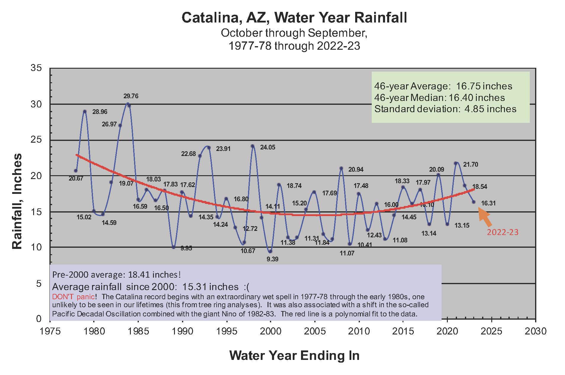
Since the chance of measurable rain before the end of September 2023 is nil and none, I thought I would post an updated plot of the Catalina Water Year precipitation totals since records began at Our Garden from the 1977-78 Water Year, October 1 through September 30:

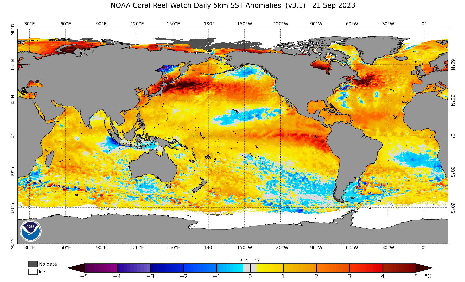
With an El Niño in the wings, it may be that the current recovery from the droughty years from 2000-2010 will be enhanced.  Ninos are supposed to bring wetter conditions the the Southwest. In case you think I am lying about a Niño in the wings, here is a chart of sea surface temperature anomalies I just grabbed from here:

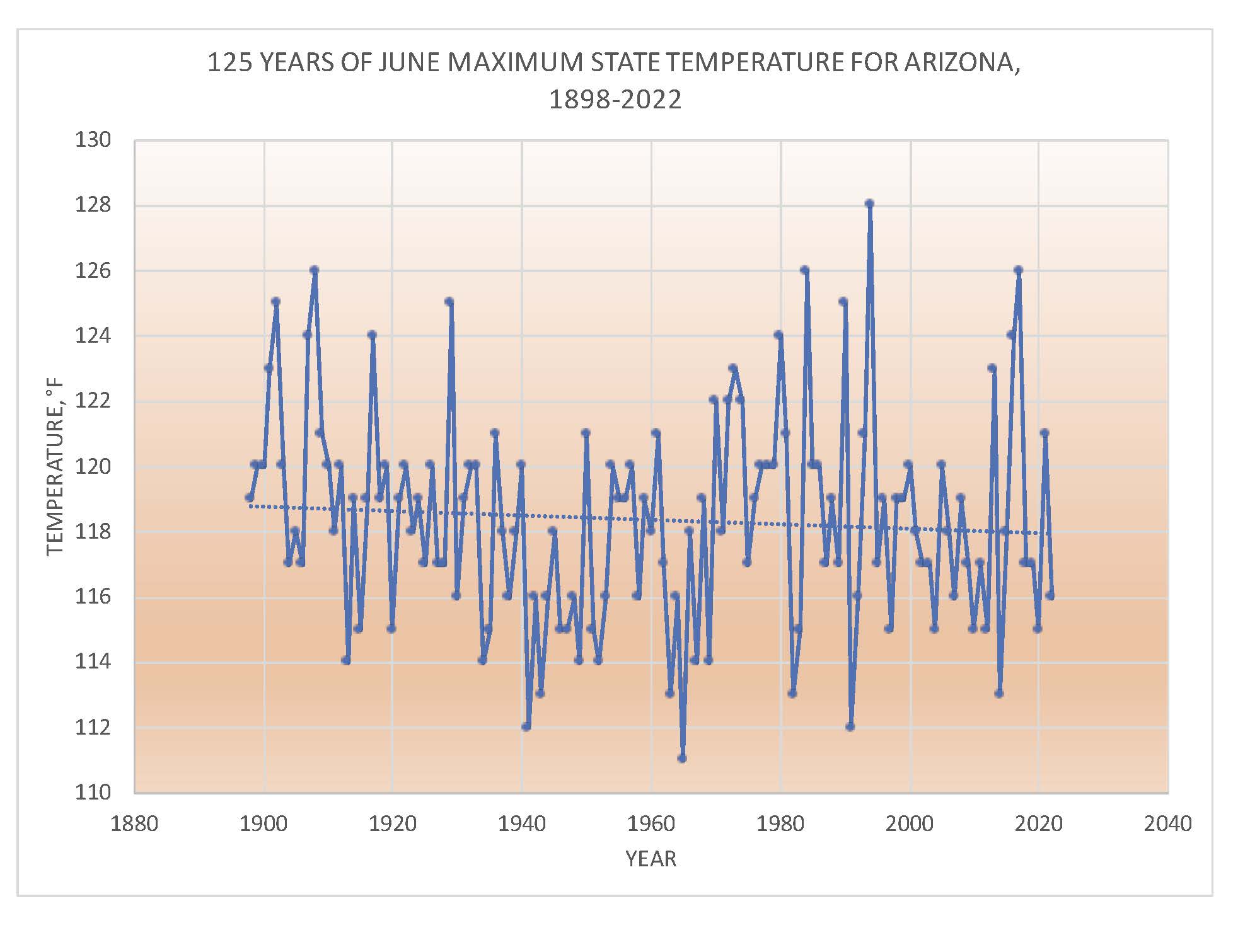
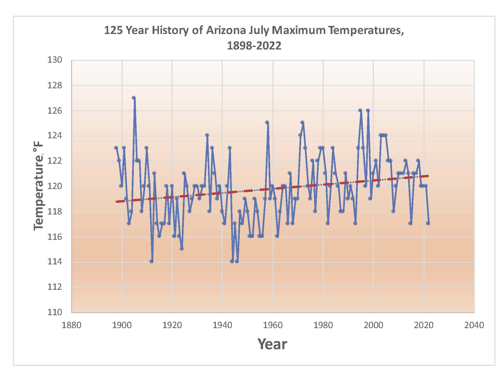
While we’re in the subject of weather, I am going to add these plots from the NOAA publication, “Climatological Data, Arizona.”  In EVERY one of these monthly publications is a table of the highest temperature observed ANYWHERE in the state since the summer of 1898.  I wanted to see how much they’ve been increasing in June and July over the 125 years since these publications started coming out.  After all, we’ve been hearing a LOT about “extremes” increasing.  I don’t why I even bothered to do this, what a waste I am sure it will be; the extremes will be shooting upward!

But, anyway, here are those plots with trend lines:

Not much going on, especially of late.  July has an overall upward trend since records began, but that last 50 years or so don’t seem to be following that upward trend.  And how can June exhibit a slight downward trend?  Not what I expected.   I dunno why.  I will leave it to the “extremists” to explain.

Thanks for reading, if anyone does.

Art, retiree, Cloud and Aerosol Research Group, University of Washington

“Peru’s Niño”

I thought you’d like to read this (Peru’s Niño), forwarded to me by Niño expert, Nate M.   Pretty incredible to read about what is happening down there in the wake of the Big Niño of 2015-16,  which really turned out to be more of a couch potato in terms of weather production in the Great SW.

But, all this winter,  along the Equator near the coast of South America, there has been something we used to call an “El Niño”,  but is downplayed or ignored these days because of a new definition that seemed to explain more weather when it occurred, “Region 3.4” a large zone along the Equator WAY out in the Pacific rather than something near the South American coast (that zone now called, “Regions 1 and 2”),  as nicely illustrated by NOAA here.

But what has been the effect of what we might call the “Classic Niño”, a warm strip of water along the South American coast, one that doesn’t extend too far into the Pacific?  “Read all about it”, as they used to say.   Its pretty remarkable.

And here’s what the SST field looks like.  Its boiling down there off South America!  (Speaking figuratively, of course):

Sea surface temperature anomalies as of yesterday from the Navy!
Sea surface temperature anomalies as of yesterday from the Navy!  Wow.  That hot water is fueling giang Cumulonimbus clouds, ones that spew out huge anvils that can affect the weather in the mid-latitudes, disrupt the normal winter patterns of where highs and lows like to go.  Could such a warm anomaly, limited to the near coastal region of South America, have created this astounding winter in the West?

Peru’s Niño can be thought of as a “classic Niño”, the ones written about in the decades before about 1990 or so when the definition of what constituted a  NIño (or Niña) was expanded and delineated more sharply among several definitions that were floating around. We ended up focusing on a region WAY out in the Pacific Ocean called, “Region 3.4” that SEEMED to explain more over the prior years.

What’s so interesting about this is that the “Classic Niño” has been underway pretty much all this winter, and we’ve had, especially in California, a classic Niño response; that is,  abnormally heavy precip farther down the West Coast that no one anticipated.

Hmmmmm.

Well, the correlations with Cal precip and “classic Niño” occurrences will take a huge jump upward after THIS winter!

End of Statement (hand-waving)  on Niñoes.

——————————–

Local weather statement:  for immediate release

Cooler, fluctuating weather foretold here for that latter part of March, I don’t know how many weeks ago, is on the doorstep after the long, anomalously hot dry spell.  Poor wildflowers have been suffering, too, fading, looking a little stunted after a great beginning, one rivaling the great displays of 2010.

All of the local weatherfolk are on top of this now, and so no point recasting that stuff.  HECK, you can go to Weather Underground1
and get as “good as can be” forecast for Catalina (Sutherland Heights) out to ten days!  And, there’s nothing worse for a weather forecaster with forecasting in his blood, than to be excited about an “incoming” and when you mention it to a neighbor he replies, “Yeah, I heard about that already.  Supposed to get a quarter of an inch.”  There is no air whatsoever in the “balloon” after that.  So, if you have a weather-centric friend who says something about the upcoming weather, pretend that you haven’t heard about it yet, “DON’T say something as hurtful, as “Yeah, I heard about that already.”

So, here, we go the long route because most weatherfolk are afraid to go too far into the future because its often WRONG.  Our models tend to lie a lot after about even a week, so only the brave go out even ten days!

However, here, we go out as much as two weeks and more because its not a truly professional site but rather want to get something out there earlier than other people, sometimes called a “scoop” in the news and weather business.  That’s why our motto here is, “Right or wrong, you heard it here first!”  Furthermore, if a longer range forecast posted here is WRONG, you won’t hear about it anymore!

Cloud maven person will say this about the first incoming of several fronts:  comes in early Thursday morning, its strong!    Rainfall potential:  10% chance of less than 0.12 inches, 10% chance of more than 0.75 inches.  Best of those is the average, or about 0.4350 inches in this one.  It has great POTENTIAL to be a soaker, but mods have been all over the place; hence, the large range of potential amounts.  At least some measurable rain seems to be in the bag, a paper one please, because plastic is insidious.  Note, CMP’s forecast is more generous than that found in WU’s latest forecast for Catalinaland.

The weather WAY ahead, unprofessionally so

Let us look beyond the professional forecasting limits to April:

We know we got several storms/fronts zipping across AZ as March goes out like a lion, but what about April?

Looks like that pattern will continue into April with temperatures below normal for the first part.  The end of the unprofessional forecasting portion of this blog, though we do have our NOAA spaghetti to hang our umbrella on….  Check it out for about two weeks ahead.

Some clouds recent clouds, including a couple from yesterday

DSC_2744
2:33 PM.  Yesterday afternoon saw a few globs of lenticular forming on top of mini_Cumulus clouds, ones that made you think the summer rain season could be at hand, given the 90+ heat of yesterday around these parts.
12:52 PM.
12:52 PM.  A high  (above 30 kft above the ground) and cold (less than -40°C patch of Cirrocumulus cloud that is going to transition to CIrrus over the next 10-20 minutes.
DSC_2737
1:12 PM:  Later that same patch as those cloudlets spread out and merge into just an ordinary Cirrus after being that delicate-looking patch of Cirrocumulus. Most Cirrocumulus clouds are not this cold, but rather evaporate or fatten into larger elements of “Altocumulus” clouds, rather than transition to Cirrus.
DSC_2728
Had a nice sunset a couple days ago (15th), some liquid Altocumulus cloud slivers with higher Cirrus.

The End

———————–
1Although “Weather Underground” might sound like an org has a radical origin, maybe something left over from the late 1960s, this particular one was NOT formed by 60s “weatherman” terrorists like Bill Ayers and Bernadine Dohrn (the link is for those of you who may have set trash cans on fire, as happened at San Jose State to protest the Vietnam War, to look back at those days in horror or nostalgia; take your pick) , but rather by genuine weather geeks (haha, I count myself among them, those that can’t get enough of weather, there can never be too much, like the guys mentioned in this “Cloud City” article.)

Catalina WY progress report; Cal WY update, too, since I grew up in Cal

I thought you’d like to see this:

As of the end of February 2017. We're pretty average, but it took some "heavy lifting" in December and January to get there.
As of the end of February 2017.  You can see were right about at the average for the Water Year,, but it took some “heavy lifting” in December and January to get there.

Doesn’t look promising for much rain here in Catalina in March, however.  No rain in sight through the next 10 days at least.

Let’s check our 7 inches with what’s happening upwind, say, in CALIFORNIA, and see if there’s been any drought relief there, through February,  via the CNRFC:

California water year totals through the end of February 2017. Note one station in the central Califorina coastal range is already over 100 inches!
California water year totals through the end of February 2017. Note one station in the central Califorina coastal range is already over 100 inches!  There are 20 stations already over 100 inches as can be seen from the table at right.  March looks to have substantial rains north of SFO, which will add appreciably to those highest totals.  Amazing!  You can go to the CNRFC and expand these interactive maps, btw.

As you are likely to know from many media stories last year, Cal was in a drought siege of five straight years,  with but got a little relief last year in the northern part thanks to help from  the giant Niño, one of the strongest ever.

Alas, it was one that failed to deliver as the big rain producer for the south half of Cal and the SW in general as was expected.

In case you’ve forgotten how bad things were in Cal, let us look back at what was being said, those horrific appearing drought maps,  and also how hopeful were were at the time  that the Big Niño would take a bit bite out of drought.  This is a really good article:

https://www.climate.gov/news-features/event-tracker/how-deep-precipitation-hole-california

Then, when the Big Niño faded away like maple syrup on a stack of buckwheat pancakes last spring and summer,  we were surely doomed for more dry years.  And, for a time, the dreaded cold tongue of water in the eastern equatorial region, the so-called, La Niña, started to develop, which would be no help at all for  a good rain season like a Big Niño is, usually.

The Niña faded away, too, to nothing as the winter went on, so we really didn’t have much going on in the tropical Pacific to help us figure out what kind of winter rainfall regime we were going to have om 2016-17.  Not having anything going on meant winter rainfall could go either way, a difficult to figure out situation for season forecasters.

In retrospect it is pretty astounding how big a signal must have been out there SOMEWHERE that this winter was going to be one for the history books on the West Coast in general, and in particular, for Californians.  Californians saw their drought chewed up and spit out in a single winter, including snow packs so high the height of some mountain peaks have been revised.  (I’m kidding.)

No one saw such an astounding winter coming.

This winter sure makes one think of the QBO (Quasi-biennenial Oscillation, one up there in the Stratosphere where there’s almost no air (haha, well, practically none)…  Did the QBO have a role in this astounding winter;  was there a delay in the effects of the Big Niño even without a bunch of convection in the eastern Pac tropics?  Doesn’t seem that could be right…

But, William “Bill” Lau, U of Maryland scientist,  reported some statistical evidence of  such a lag way back in ’88 due to a QBO connection of some kind and ENSO, no physical cause could be discerned, however,  not yet,  anyway.  Lau, 1988, is reprised below for readers who want to go deep:

Annual cycle, QBO, SO on global precip J Geophys Res 1988ocr

Sure has looked like the Big Niño WY we expected last year!

Some recent clouds; after all, this is CLOUD maven, not RAIN maven:

I’ve been kind of holding out on you.  I dropped my camera and busted it.  Its no fun taking pictures when you don’t have a real camera.  Still doesn’t work right, but take these anyway:

March 4th, afternoon. Hope you logged this; the rarely seen CIrrus castellanus (almost "congestus" in size) or, informally, "Cumulo-cirrus."
March 4th, afternoon. Hope you logged this; the rarely seen CIrrus castellanus (almost “congestus” in size) or, informally, “Cumulo-cirrus.”
Poppies are out, btw. Nice display on "Poppy Hils" just across and southwest of the Pima County Pistol Club, off Bowman.
Poppies are out, btw, in case you haven’t noticed. Nice display on “Poppy Hils” just across and southwest of the Pima County Pistol Club, off Bowman.
DSC_2499
March 4th, late afternoon. Nothing terrifically special in this tangle of Cirrus spissatus (“Cis spis” to cloud folk) but I thought it was just a really nice scene

Moving to the next day, Sunday, that REALLY windy day:

March 5, Sunday morning 6:13 AM. Altocumulus lenticularis alerts cloudwise folk to the possibility of windy conditions although it was already windy.
3:55 PM, March 5th. After a day of solid Altostratus overcast with underlying Cumulus and Stratocumulus, a layer of Altocumulus began to move in to add a little more interest to the sky.
3:57 PM. Looking to the north revealed that some of the lower Cumulus/Stratocumulus complexes reached heights where ice could form. That smooth region on the bottom and right side of the cloud is a fall of ice from this cloud with a RW- (text for "light rainshower") if you like to text stuff) right below that. This is not a lot of ice and so you'd be thinking the cloud barely made that ice-forming temperature.
3:57 PM. Looking to the north revealed that some of the lower Cumulus/Stratocumulus complexes reached heights where ice could form. That smooth region on the bottom and right side of the cloud is a fall of ice from this cloud with a RW- (text for “light rainshower”) if you like to text stuff) right below that. This is not a lot of ice and so you’d be thinking the cloud barely made that ice-forming temperature.  CMP doesn’t think it was caused by an ice fallout from that higher layer, which sometimes can happen.  Let’s look at the most timely sounding, just to check.  From the real Cowboys at the University of Wyoming, this:
Ann 2017030600.72274.skewt.parc
The TUS sounding which I only now just saw, showing a vast separation between the lower Stratocumulus and the higher layers of Altocumlus and Altostratus on top. Note, too, that over TUS the tops of the lower cloud is not quite at -10°C the temperature we start to look for ice formation in AZ. However, our clouds were NW of that balloon sounding, and it would have been that tiny bit colder, and tops were also lifted some when they passed over the Tortolitas earlier, meaning that the tops of this complex were colder than -10° C (14° F) at some point.

Wow, too much information….after a hiatus in blogging I feel like that  Oroville Dam in California, metaphorically overflowing with too much hand-waving information.

6:03 PM, March 5. Its still real windy. Line of virga brought a few drops when it passed overhead at 6:30 PM.
6:04 PM. Nice dramatic shot toward Marana as the backside of the middle cloud layer approached allowing the sun to shine through.
6:09 PM. Virga getting closer. May have to park car outside to make sure I don't miss any drops!
6:09 PM. Virga getting closer. May have to park car outside to make sure I don’t miss any drops!
6:22 PM. SW-NE oriented virga strip about to pass overhead. Drops fell between 6:30 and 6:40 PM, but you had to be outside to notice, which you would have been as a proper CMJ eccentric.
6:22 PM. SW-NE oriented virga strip about to pass overhead. Drops fell between 6:30 and 6:40 PM, but you had to be outside to notice, which you would have been as a proper CMJ eccentric.  You would have WANTED that trace of rain report, maybe slackers would not have observed.
6:30 PM. Climax; the great sunset allowed by that backside clearing.

The End, at last!

Western drought status: before and after the Big Niño erupted

“BN”, sometimes referred to in the media as the,  “Godzilla Niño” of 15-16.

Before, one year ago, the drought status as presented by the National Drought Monitor folks there in Cornhuskerland, Lincoln, NE:

First, a legend, no, not a story, though we could write one,  “The Legend of the Ghost Niño of 2015-16“,  but rather a guide to the colorful drought intensities on the maps below:

Drought intensity legend

One year ago


Western drought status as of April 7th, 2015.

Now let us look closely below–you’ll have to–to see what the Big Niño has done to ameliorate drought so far THIS  water year (since Oct 1):

Western drought status as of April 5th, 2016!

Of course, the giant low centers spinning around in the central Pacific sent a stream of large waves over and over again that blasted the Cal coast. That was expected, and verified. But not much else did. Drought should have increased in the Pac NW–recall it was forecast to be drier and warmer due to Niño conditions.  Instead, the Pac NW had record amounts of winter rain!

Cal, especially, central and southern were to be slammed. Southern Cal residents were advised to consider purchasing sandbags in one media story last fall.  And, of course, we here in AZ are profoundly disappointed; conditions have only improved some in the north part of the State.

Well, of course, there’s not one dry meteorological eye in the house after a bust of this magnitude.  And when our best models predicted giant West Coast storms that looked like the kind we were expecting due to the Niño, even though they were 10-15 days out, they seemed sure to happen.  CMP, bloated with confirmation bias,  was sucked in several times this past winter.

Sure, we knew that Niño correlations with weather are not 1.00, that is, perfect, still, the “signal”,  the size of the Niño, was so huge we figured it had to come through with those mighty storms striking the lower West Coast as happened in 1982-83 and 1997-98.    Those correlations, as strong as they were, of course, were limited in number since these large events are rare.  Those correlations will, let us say in place of cuss words,  “degrade.”

Oh, me, what will we say when the next Big Niño appears?

The weather ahead

You’re probably pretty excited about the wind and very cold air just ahead.  CMP is.  And, with the jet stream at 500 mb (18, 000 feet or so–5.5 km above sea level) eventually circumscribing us with its charateristic moist lower region of air, we should just enough moisture for some isolated very light showers, probably just in the Catalinas, during the period of low freezing levels that hits late Friday and continues through  Sunday.  Low freezing levels mean even moderate Cumulus clouds could form ice, leading to virga.

Amounts could, at the most,  only be a few hundredths here, and most likely we will be missed; precip just limited to snow flurries on Ms. Mt. Lemmon and thereabouts.  The U of AZ mod sees the cold blast arriving late Friday after dark.

On the other hand, Saturday and maybe Sunday as well,  will be good days for you to practice your ice in clouds detection skills in smallish Cumulus clouds.

The weather way ahead

Still looking to see at least two more troughs and chances of rain during the last two weeks of the month.  NOAA ensembles suggest so.  Best chances, 23rd-25th, and again around the 28th or so.

Some cloud shots from our little 0.01 inch rain day on Tuesday:

6:02 AM, Tuesday.
6:02 AM, Tuesday.  A summer-like scene, complete with thunder frames the post dawn hours.
DSC_3219
10:35 AM. After the morning excitement cleared off, a pretty Cumulus congestus erupted north of Saddlebrooke town. There’s a hawk in the photo.
DSC_3223
12:12 PM. That Cumulus congestus and its sisters, were able to reach the level of glaciation, and wind shear, send a plume of ice downstream toward the east, and rain below that overshooting turret.
DSC_3229
2:36 PM. Pretty much the perfect cloud for ice in cloud studies. As the air warmed aloft and capped the Cumulus clouds, this one just poked up high enough to form some ice. It would have been a great sample to determine the temperatures and cloud conditions at which ice onset in clouds on Tuesday.
DSC_3235
4:16 PM, Tuesday. Those shadow and sun highlights that make our mountains so darned pretty. I just never will be tired of these views!

The End


MJO and El Niño Grande battling it out in the Pacific

You’re probably wondering, as are Californian’s who live a little south of ‘Frisco,

“Where’s the wet winter in central and southern California?”

and for us,

“What happened to the Great Niño of 15-16 and all the drought-relieving rains that were expected in the Southwest?”

I think you need to read this:   MJO update

Remember when it rained so much in early January here? We were so excited, Big Niño being underway!  And all the washes were running then?

Here what this MJO update rehashes about early January and the MJO,  in case you’re too lazy to read it:

“During early January, a strong westerly wind burst near the Date Line was related to constructive interference with the ongoing El Niño.”

I didn’t want you to miss the important words.  “Constructive interference.”  To help you grasp this phrase,  this would be when TWO or THREE lineman,  instead of one,  create a “crease” for a running back who then runs a long ways, to get into the current sports ambience ahead of Superbowl Sunday, just ahead.   That would be an example of,  “constructive interference”;  for the team and its running back on offense in a football game1.


That was early January, and now its early February (the 6th),  in case you were wondering how old this post is….  Lets see what the MJO experts say later in this same briefing:

“The intraseasonal signal weakened by late January as it destructively interfered

with the El Niño.  Suppressed convection became less widespread across the Maritime Continent and shifted eastward to the SPCZ.”

You never want to read that your treasured El Niño (aka, Big Niño here) is being “interfered” with.   Dammitall!2

We were counting on the current Big Niño to make droughty things right again all over the Great Southwest!

But no, now its struggling against the Dark Forces of the MJO wind regime out there, doing its thing and is now messing around in “Phase Space 4”, this latter location is also is, historically associated with poor rains in the Southwest.3

So,  WHERE the eastward meandering MJO is right now, and the wind anomalies associated with it,  are likely taking some steam out of the action the Big Niño, by itself, would have  normally produced in the SW.

And it doesn’t seem any Nino like storms are in our immediate future, but rather what’s in our immediate future is a reprise of last year’s “Warm in the West, Cold in the East4” pattern where storms are generally shunted far to the north of us.

At least, this is now what I think is happening and why we have had such  disappointingly dry weather for the past few weeks after reading this MJO updated briefing.

By the way, don’t forget to use that acronym, “MJO” in casual conversations about weather.   It will be great to toss that out if you with neighbors or at a party, and someone sarcastically says, to no one in particular, “What happened to the big, wet winter we were supposed to have?”  That’s when you jump in with “MJO” and what’ going on and how its messing with Niño, is YOUR take on things.   I think this would be a great moment for you5!

The weather ahead

No real rain in site over the next two weeks, only passing weak troughs, maybe some marginal rain with one maybe,  as a ridge of high pressure aloft, something resembling last year’s pattern, recurs along the West Coast over the next two weeks.  Boohoo.

The End

———————————————-

1Offense is when you have the ball and you are trying to move it forward toward the “goal line.”   Men like football in particular, though it may be a subconscious thing,  because there is a clear metaphor3 to a football crossing a goal line and fertilization of female ovaries.  This, of course, explains in this context,  the exaggerated celebratory mode of the specific player who has carried the ball over “the goal line.”  Nothing knew here, well known in Freudian circles.

2Sometimes you have to cuss to get the emotions out, an author in this month’s Atlantic Magazine wrote.  Caution, this piece contains cuss words.  Personally, I don’t cuss myself.   So get the HELL off this blog if you want a lot of cussing.

3You will see this if you go to the last page of the MJO link in this post.

4Of course, “cold in the East” can always help the Arizona economy by getting more folks to bail on the awful winter climate they have there for AZ.  That would be good.

5While I normally don’t recommend cussing, it could be that using the phrase, “….that f……g MJO is f……..g  with our Big Niño” might deliver more impact and release more of your negative emotions about it.  Scorsese would approve (see Atlantic link above)


Forgetting about our mud for a moment; thinking of the danger to others as seen in future weather maps

Have had 1.75 inches here in the Heights last few days.  Horsies are tromping around in significant mud.

But, to resume a theme about others from the prior entry, those in California, they’d better be paying close attention to the weather a week and more out.  In this weather watcher’s opinion, which should count for something, California may be in for an unforgettable January.

Why?

Recall how those “ensemble-spaghetti-Lorenz” plots had an unusually constrained (contours of flow, red and blue lines that were unusually bunched together all the way from Hong Kong to ‘Frisco even 10-15 days out?  That indicated a high confidence forecast of where the jet stream would be.

USUALLY, the contours are pretty wild, scattered all over the eastern Pac after about 10 days or so,  and Cloud Maven Person got overly excited about this esoteric part of weather forecasting, and decided to write a partially decipherable tome on it.

Well, that constrained jet, blasting into Cal  from the subtropical latitudes with a terrible ferocity, has continued in model run after model run now, and CMP’s excitement has been further elevated, maybe to penthouse level now, hard to elevate it more.

Way below are a few examples from just last night’s model run based on global obs at 5 PM AST, showing a few sample of the jet stream predicted pattern at 500 millibars, or around 18, 000 feet (from IPS MeteoStar, as usual).

THESE are extraordinary maps, and extraordinary maps mean extraordinary storms, AND they are appearing with extraordinary consistency.

They are also compatible with what we saw in those ensemble-spaghetti plots of a few days ago.  So, like the “Frankenstorm” of 2010 that hit California, this series of strong storms hitting Cal in just over a week, will be considered to have been “well-predicted” by those crazy plots.

Is FEMA ready?

I think they will be involved at some point.

But, too,  this is a forecast series where we (those in Cal) have lots of time to get ready for big, destructive events.

Like what?

For Cal, the usual.

1) Huge waves smash the coast, some home roll into the ocean. With a jet having a gigantic fetch from the Pac, huge waves are a certainty, surf will definitely be up, if that’s what you do because the surface winds will ALSO have a huge fetch to build those giant rollers.

2) Winds.  At some point, hurricane force winds blow stuff around in one of more of the low centers generated by such a powerful jet stream.   Looking at the pattern, I think one within this storm series may produce 100 mph winds or more somewhere in Cal.

3) Flooding.  Can the nearly empty Cal reservoirs we’ve heard so much about be filled up in a series like this, something that might go on for one to two weeks?  I think so,  some anyway.  But this is a truly wild thought, and as you can see, CMP is kind of out of control here.

It is certain that the rains with one or more of the low centers that slam the West Coast during this series will produce rains of 10 or more inches in a day  in the hill and mountain regions of Cal.

Also, the series begins with a strong, but maybe not exceptional storm about 8 days from now, this after a pretty good rain has already occurred, so the ground is going to be pretty wet when the Big Series hits.

The jet stream pattern strengthens and shifts farther south with each day after this first major storm, and that’s when the real onslaught will hit.

I don’t want to get people overly excited like I am, but I am terming these, and the whole recent series of unbelievable jet streams bashing into Cal, and even Baja!, “the California calamity maps.”

Valid Monday, January 18, 5 AM AST.
2016010900_WST_GFS_500_HGT_WINDS_240
Valid, Monday, January 18, 5 PM AST.


Skipping ahead:

2016010900_WST_GFS_500_HGT_WINDS_312
Valid Thursday, January 21st, at 5 PM AST. EGAD! WHAT a monster!
2016010900_WST_GFS_500_HGT_WINDS_336
Valid 5 PM, January 22nd. One blast is finishing up, but look at the jet entering on the left/west side. Once again, “egad!”


Skipping ahead some more….

2016010900_WST_GFS_500_HGT_WINDS_384
Valid at 5 PM AST, January 24. Upper cut to jaw of Cal from the Pacific. This one would be quite bad in rain, wind, floods.


Now the timing of these things WILL VARY as the mod runs keep churning out results, but in CMP’s view, the pattern that will cause CA havoc is locked in now, promulgated ALMOST without doubt by our Big Niño.

Here is another amazing map from a prior run, that just makes your jaw drop due to what the models are sensing is “out there” for Cal and the West Coast:

This is looks like it was for another planet, the jet SO POWERFUL and heading into Baja!
DSC_2317
Crespuscular rays due to light rain from precipitating Stratocumulus (i.e., “praecipitatio.”, if you want to impress your friends.)
DSC_2355
Pretty good sunset color. The clouds?  Stratocumulus.
Weather station and mountain sunset color.  You don't see that too often....
Weather station and mountain sunset color. You don’t see those together too often.  Mountains topped by non-precipitating Stratocumulus clouds.


How will SE AZ do?

Seems like passing rains will hit during this CA bludgeoning period, but floody weather not expected.

Since we’re pretty much at our average total for the month of January right NOW, CMP is going out on a limb and predicting an above normal total for the WHOLE month.


The End

Lucky snap; studies in orange

From the past three days, these:

DSC_8279_2
From a single snap, this LTG complexity caught three evenings ago.
DSC_8278
This was taken seconds before the big flash, which kind of ruined the exposure when it happened.
DSC_8244
This last series of photos were taken the evening before. Kinda pretty I thought.

DSC_8238 DSC_8232 DSC_8231

In other news…..

Record July rains are falling in much of the coastal and intermediate valleys of southern California as the pathetic remnant of once proud Category FOUR hurricane Dolores makes landfall there today.  Places like San Diego have had well over an inch, unheard of in July.  August, not so much, since tropical storm remnants have passed over southern Cal in a few Augusts.  Remember August 1977, when two inches fell on LA due to a tropical storm remnant?

That also August deluge in Los Angeles, by coincidence I am sure, preceded the big Pacific Decadal Oscillation (PDO) switch in which low centers in the Pacific shifted farther to the south beginning with the 77-78 winter and the Arctic warmed up.  Wallace et al 1995, Science Mag, discoverers of the PDO, were claiming that the PDO shift had seriously muddied up the global warming hoopla of the time, suggesting caution in those global warming claims.

Nobody really paid any attention, since it was about to get even WARMER in the years immediately ahead, like in the 97-98 winter when a giant El Nino, like the one now out there, spiked earth temperatures to a record high of the time.

By the way,  the phrase, “global warming”,  has been supplanted by the phrase, “climate change”, one that has been bastardized from its original use since climatologists have always considered the phrase,  “climate change” a temperature-neutral, precipitation-neutral, could-go-either-way one, but as you know today it is one-tailed;   that is, “climate change” today has only  ONE meaning by those (often non-professionals) who use it;   that an anthropogenic WARMING of the climate is underway with its attendant effects on precipitation and life itself.

When the earth stopped warming some 15-20 years ago, the global warming phrase heard all over the media had to be supplanted with something else, of course.  I laugh, bitterly really, when I think of award-winning science geophys writer, Richard Kerr, of Sceince Mag, who wrote an article in Science, quoting the Hadley Center and such, titling his 2009 article about the hiatus in the rise in temperature, “What Happened to Global Warming?”

Of course, today such a title would not be allowed in Science Magazine.  But then, Richard Kerr could not have titled his article, “What Happened to Climate Change?” either, since climate change is always happening on this planet, probably the others like it.

Speaking of mud, or muddying things up, some scientists (Karl et al.)  are now claiming (in 2015)  there was NO HIATUS in the earth’s temperature;  that its been rising all along!  This astounding finding is due to some manipulations/”corrections” of existing data and use of African and other data not previously available.  You can read about this in summary form: Lost and Found_Sci 6-5-2015

This made me feel sad for the great scientists of the day, like Susan Soloman and others,  who have generated hypotheses about WHY the pause in the rise in temperatures has occurred, even publishing those hypotheses in high end journals like Science Mag or Nature.

Those folks are bound to be pretty embarrassed now since they may have been explaining nothing that was real.  It doesn’t get more embarrassing than that;  kind of like explaining N-Rays, that bogus radiation reported after the turn of the century by French scientist, Renee Blondlot, at Nance University (the “N” was for Nance).  Man, was Blonbdlot embarrassed when American physicist, Robert Wood, went to France to see “N-Rays” for himself and found that they were imaginary and reported them as so1.  N-Rays, though they had been “confirmed” in numerous studies, were soon gone from the scene, one of the greatest mass delusions known to science.

Was there REALLY no hiatus, that the Hadley Center in England, perhaps the foremost climate center in the world, was somehow misled when they were reporting a pause or hiatus in warming?  One thinks that the Karl et al 2015 report will get a LOT of scrutiny.  Stand by….

More TSTMS in the area today through most of the summer.  Hope one hits here in the Heights.  We’re falling behind our 3.5 inch or so average for July.

The End.


————————

1It was the story of American physicist, Robert Wood, as told in the 1982 book, Betrayers of the Truth: Fraud and Deceit in the Halls of Science,  by William Broad and Nicholas Wade, that partially inspired your Catalina Cloud Maven.com to go to Israel in 1986 to see the clouds for himself since,  in his experience after years of airborne cloud work at the University of Washington), the cloud reports emanating out of Israel were goofy, also the likely product of someone’s imagination.  Those Israeli cloud reports WERE goofy as found by your author (1988 pub), and independently by others (U of Tel Aviv).

Tweedledee and Tweedledum; ’97 and ’15

This just in from someone else, Nate M1:

When sea surface temperature (SST) anomalies from the Great Niño of 1997-98 are compared in June 15, 1997 with the one now developing on June 15, 2015 the differences are nil.

That’s it.  Hope you like it.

The one in 1997-98 was a “Comprehensive Niño”, that is, it included sea surface temperatures that were much above average  in both the Classic Niño locale,  just off the coasts of Peru and Columbia, and extended all the way to, and included,  the “New Niño” locale, the one way out there in the Pacific along and a little north and south of  the Equator (called “Region 3.4” by real scientists2).   That 97-98 one was gigantic; earth shaking; the one in progress also appears like a gigantic one, too, so far, to add fudge words.

Take a look for yourself, first June 15, 2015, and below,  June 15, 1997.

PastedGraphic-4 PastedGraphic-5

Not only was it extraordinarily wet in the Southwest that water year,  especially  in central and southern California (LA had over 30 inches, and mountain stations over 70), but the Great Niño of 1997-98 was also associated with a leap upward of the earth’s temperature.  So, be wary of a jump in the earth’s temp during the next year or so.  Catalina is  already be experiencing a temperature jump; 109 F here yesterday.  Egad.

Let’s hope, too,  that this Niño is more like the other “recent” Great Niño, 1982-83 rather than the one in 97-98.  In the former one, Catalina received more than 32 inches of rain during that water year,  October 1, 1982 through September 30, 1983.  In 1997-98, we “only” received 24 inches (about 7 inches above average our ~17 inch average here in Catalina).  Old timers still talk about how the washes flowed all year in 82-831.  Recharge those aquifers!

Ninos strengthen the southern portions of the jet stream by increasing the temperature difference between the Tropics and the mid-latitudes, so that low pressure systems are larger and stronger in the middle and lower latitudes of the eastern Pacific (see Bjerknes and “company”, 1960s).  Typically, the  low pressure centers that accumulate in the Gulf of Alaska are less vigorous, their strength sapped by the shift of the stronger winds aloft toward the south.

Huge plumes of cloud arise over these warmer than average waters from masses of Cumulonimbus clouds where the trade winds of the southern and northern hemisphere are colliding.  Those vertical fountains of moisture eject clouds out of the tropics and of middle and high clouds that  get caught up in the stronger cool season troughs that come by, enhancing their rain and snow output, and leading to a much cloudier overall cool season.  Recall that Biosphere 2 largely failed due to the excessive cloud cover of the 92-93 winter in southern Arizona associated with a Niño.

BTW, It only takes a few degrees of ocean surface warming for clouds to transition from an area of passing light showers with little accumulation, showers that falls from modest Cumulus clouds or clumps of Stratocumulus,  to giant, recurring clusters of Cumulonimbus clouds.  When cloud bases are warmer, the amount of water being condensed is greatly increased, and that in turn, allows the clouds to be warmer inside, more buoyant,  than cloud are when they form over those normally very cool eastern Pacific equatorial waters.

Unfortunately, a lot of wildlife down around the Equator in the eastern Pacific, such as around the normally semi-arid Galapagos Islands and other islands to the west,  is severely disrupted by the sudden onset of frequent, heavy tropical rains.  The same is true for the coasts of Peru and Columbia where normally very dry areas are awash in water.  Fishing gets crappy, too.

Caveat

HOWEVER, note in the plot for 2015 how much the larger the area of  above average SSTs in the Gulf and eastern Pacific are compared with 1997.  Hmmmm.   Not sure how that will play into current Great Niño.  It would be prudent to contain our excitement to some extent since weather NEVER exactly repeats itself.  Don’t start gathering animals and building an ark just yet.

So, am a little worked up about 2015-2016 water year, as I am sure you are, too.  Thanks Nate, I think.

In the immediate future, how will all that excess warm water affect our upcoming summer rain season?

I don’t know.  Clueless, really, as are the people who actually study the summer rain season in detail.  Could go either way, dry or wet. Lot of uncertainty about how a good Niño affects Arizona weather in the summer.

But we might well have “better”, stronger tropical storm remnants affect us in the fall, maybe like last September and October when what turned out to be a dud Niño was in formation and those wamer waters combined with extra warm waters off the immediate Baja and California coasts (this latter phenomenon now deemed the “California Niño”), that helped sustain tropical storms as they drifted northward.

Once again, ending with a lot of ? and the Mysterians….”96 Raindrops”; “…too many raindrops for one heart.”

The End

——————————

1Nate M., formerly of the University of Washington’s Climate Impact Group, now at NOAA’s Southwest Fisheries Center, Monterrey, CA.  Nate and I used to have “punting wars” right there in the middle of Husky Stadium.  Oh, yeah.

2Its the region between 120 W and 170 W longitudes, 5 N and 5 S latitudes), and in the area in between.  HOWEVER, in the plots above, note that the longitude has been incremented upward from the Dateline of 180 W, and continues to increase so that 120 W longitude is 240 degrees W longitude.  This is not something that Cloud Maven Person did for humor, like claiming that the Equator goes through Hawaii, as he sometimes does to see if anybody notices the error, is reading his blog.  Hasn’t been caught yet.

3Heck, add a few more days to that 82-83 water year from Oct ’83, so that the above total would include the rains from Tropical Remnant (TR) Octave, and you’d have a Seattle-like 36 inches of rain here in Catalina!  Unbelievable.
 

El Niño Risin’, “Cal Niño” persists; another comet passes over Tucson?

“I think a year ago I sent you the early alert that Eel Ninyo is coming!!! Well, I think I was about 1 year early … the real deal seems to be gearing up for a more major appearance this year … check it out: http://www.cpc.ncep.noaa.gov/products/precip/CWlink/MJO/enso.shtml

“My fingers are crossed for a much more typical event for 2015/16, but then again we seem to be in a very similar place as we were last year at this time (caveat part of e-mail) only a bit warmer in the tropics.”

“We shall see!”

—-from Nate M., NOAA SW Fisheries Center El Niño expert, personal communication, received just yesterday!  Excitement abounds!

But,  we will see as well…

Below, a different SST anomaly visual from NOAA:

Global sea surface temperature anomalies from NOAA, as of March 30th.  The eastern Pacific and eastern equatorial waters are aflame, figuratively speaking, of course.
Global sea surface temperature anomalies from NOAA, as of March 30th. The eastern Pacific and eastern equatorial waters are aflame, figuratively speaking, of course.  Both the “Classic Niño” (off Peru) and “The New Niño” regions, the latter in the mid and eastern Pacific,  have above normal water temperatures!

There is a LOT of warmer than normal water out there!  As we know now, the newly discovered “California Niño” helped tropical storms whisk into Arizona late last summer and fall stronger and wetter than they normally would be by providing warmer waters than normal over which they traveled while heading toward AZ.  Think of something like the highly-caffeinated “Jolt Cola”  in sea surface temperatures for those storms.

Slackening onshore winds along the West Coast last spring and summer created the Cal Niño, something now known to occur from time to time over the decades.  And that warm water wasn’t much perturbed by strong storms during the winter, ones that can mix colder water to the surface.  The Cal Niño means that IF any storm strikes the West Coast, they would be a little wetter than usual since the air holds more water in it when its warmer.

In the meantime,  the much-heralded El Niño of a year ago1 deflated like a New England Patriots game time football into a pile of nothing, wrecking the expectations of frequent late winter and spring rains  in the Great SW.  Thankfully we had that ONE great, several inches rainstorm at the end of January2 and a couple of vegetation-sustaining rains thereafter.

What does all this mean for our immediate future?  Will the late spring be wet?  Will we have a great summer rain season?

I don’t know.

But, next winter could be great!

Today’s clouds and weather

Rain is expected to be around today, sprinkles, maybe some thunder due to a weak low aloft passing to the south of us.  Cloud drift is supposed to be from the east off the Catalinas, and with the unusual warmth, the day will LOOK like a day in July or August, nice Cumulus building off the mountains in the later morning, reaching the ice-forming level fairly quickly, and then, as you know, out pops the virga and precip.  So, it will be a nice photogenic day for you.  Check this nice graphic of the expected temperature profiles today from the U of A.

 The weather WAY ahead

Recall that today and tomorrow, at one time, as was mentioned here, we were going to experience one of the greatest storms ever observed for this time of year.  Well, today’s situation is what’s left of that forecast, a coupla puny showers around, and, sure a trough is here all right, but what a disappointment!

In the meantime, forgetting about the perpetual disappointments for big rains foretold about two weeks in advance, we are once again excited by another great rain here in the far model horizon of just two weeks from now, in mid-April!

Valid at 5 PM AST, April 14th.  Could put a real dent in our usual April dryness!
Valid at 5 PM AST, April 14th, only 348 h from now!   Could put a real dent in our usual April dryness!  Colored regions denote those areas where the WRF-GOOFUS model has calculated through VERY sophisticated means,  where precipitation has fallen in the prior 12 h!  This from global obs taken at 5 PM AST last evening.

Yesterday’s clouds and more

From two days ago.  Another comet passed over.  Didn't read anything about it, though.
From two days ago. Another comet passed over. Didn’t read anything about it, though. I guess the astronomers have seen enough comets. Probably a little jaded by now by so many of them.
Close up.  You can see its trailing ice and dust, burned off by the sun.
Close up. You can see its trailing ice and dust, burned off by the sun.  Its great to live in a place where so many comets go over!  I think that’s two or three in the past year!
Awful green here in Arizona.  I wonder how many people know how green it is here?
Awful green here in Arizona. I wonder how many people know how green it is here?  I think a LOT of people have no idea how green it is here (at this time of year).


5:58 PM.  Thought for a fun shot I would show you some castellanus from yesterday.
5:58 PM. Thought for a fun shot I would show you some castellanus from yesterday.
6:45 PM.  Sunset.
6:45 PM. Post sunset, Altocumulus under patches of Altostratus, or, Cirrus spissatus if you like.


The End

———————-

1Not just here, but by people that know more than I do, like the CPC.

2Water is still coming down from the mountains from that 4-6 incher in the Catalina Mountains, water that can be seen still pouring over great boulders in the higher reaches of our mountains producing  the morning “glistening rocks” phenomenon.  “Glistening Rocks”….   That would be a great title for a love song, a sad one, because as we all know, sooner or later, we won’t see the water producing glistening rocks anymore from the big January rain.  So it would have to be about a love that starts out so strong, but then fades over time, finally disappearing altogether.

While waiting for the rain, this wind report from southern Cal

The report below was supplied by stalwart metman, Mark Albright, U of WA, who snooped around to see if a forecast of 50-100 mph in southern Cal made from this blog on JANUARY 18th had any credibility at all for a 50-100 mph wind event in southern California:

“Looks like your forecast of 2 days ago1 has already verified.  Sill Hill, 20 miles NE of San Diego at 3556 ft, reported a gust to 86 mph (75 knots) at 13:50 UTC this morning.

“0430 AM     NON-TSTM WND GST 9 SSW JULIAN            32.95N 116.64W
01/24/2015  M75 MPH          SAN DIEGO          CA   MESONET

MESONET STATION SILL HILL /SILSD/

24 SILSD sd 1300                           55   8  89 37 60  (last number is max wind gust, in knots)                                     RH=15
24 SILSD sd 1310                           55  10  88 43 63                                       RH=16
24 SILSD sd 1320                           54   9  91 43 59                                       RH=16
24 SILSD sd 1330                           54   9  87 41 57                                       RH=16
24 SILSD sd 1340                           54   9  87 40 66                                       RH=16
24 SILSD sd 1350                           54   9  85 38 75 knots (!)                                     RH=16
24 SILSD sd 1400                           54   9  94 40 61                                       RH=16 ”

-mark”

Its rare when forecasts go the way they should, and I thought I would put on a display of exceptional exultation today.

Now comes the time that the upper air disturbance that produced that 50-100 mph wind sits off the Baja coast, scoops up some moisture from the deep tropics and sends its back over southern Cal and the Great Southwest.  Still looking for a thunderstorm or two in that cloud mass somewhere, most likely west of us,  as it rolls northward tomorrow.

Here is a satellite loop from the University of Washington Huskies Weather Department.   In this loop, entitled,  “Scoop,  there it is!” paraphrasing a skit from “In Living Color“, you will see how that tropical moisture is beginning to wrap around the low off Baja, prepping it into a rain-bearing system that will be pulled northward by a disturbance approaching the West Coast.

The bottom line in this loop is the Equator, and that cloud band just north of there is the Intertropical Convergence Zone, where the trade winds meet.   The water is a little warmer than normal down there, not enough to qualify as more than a minimal “New Niño (the “Classic Niño, the one next to Peru,  is completely gone).   But modestly warmer than normal water temperatures still helps a little to send up Cumulonimbus clouds which eject moisture from the Tropics into middle latitude and sub-tropical latitude disturbances and that’s what’s happening in that sat loop;  an ejection of clouds and water vapor into that formerly dry, 50-100 mph Santa Ana wind forecast-verifying-producing upper low, a forecast that was made 6- days before it happened!  Really incredible.

A view of sea surface temperature ANOMALIES, with important annotations:

As of January 24th, 2015.

We’re sticking with the range of amounts previoulsy foretold here that could occur in Catalina, that range being pretty high due to model vagaries.  From this keyboard, the least that could fall is a puny 0.05 inches, and the most remains at 0.50 inches, which would be very nice.  Averaging those two gives 0.275 inches, also quite nice, and the most likely amount if averaging like that has any credibility at all.  This is the fun part of weather forecasting.

It has to be mentioned that the WRF-GFS nested model from the U of AZ indicates that the larger total is going to occur, this from the 11 PM AST run from last night.  That would be so GREAT!  Take a look at these great totals as they pile up, ones accumulated over the 24 h from mid-day tomorrow to mid-day on Tuesday.  So fine.

And, to make the news even better, more rain is increasingly likely two or three days after this episode!

Yesterday’s sunset:

5:55 PM.  Curling Cirrus
5:55 PM. Curling Cirrus

Today;  mostly high ice cloud (Cirrus, Cirrostratus, Altostratus) broken to overcast skies with thin spots from time to time.  Nice sunrise, hope you caught it.

The End

———————————————-

1It was on January 18th, not “two days ago”, that that astounding forecast was made, so long  before it happened I might get an award of some kind, maybe the Amer. Meteor. Soc. Rossby Medal…  That would really be great!