People were wearing jackets as temperatures got locked down below 80° F the past few days, the wind blew once in a while, sometime lifting baseball caps off “gray hairs”, and gray skies hovered over Sutherland Heights for TWO and a half days!
A surprise, few-minute gusher in the early afternoon yesterday was enough to tip the old Davis tipping bucket rain gauge once1, too, to add another 0.02 inches to the 0.08 inches we were drenched with the night before.
What’s ahead. I dunno.
Really thought THIS storm was gonna be a doozie here, not in Mexico as it is now, for Pete’s Sake. Some weeks ago it was read by my reader (s?) here that we had only a 10% chance of LESS than 0.20 inches. In fact, we had a 100% chance of 0.10 inches.
I did not see that coming. But at least March 2016 has recorded SOME rain. Some insects benefited I’m sure.
Climate folks (Climate Prediction Center) are still predicting a wet March-May for us, at least as of mid-Feb. Unfortunately, its only a little more than two inches that makes that three month period wetter than normal here in Catalinaland as we begin to dry out, and heat up.
Time for another, “I love this map so much”, so fully packed with portent:
“Valid” (what a joke) in two weeks, March 24th, 5 PM AST. Giant low moves SEWD toward the Cal coast. Strongest winds on the back side tells you its shifting southeastward. Look how big it is!
Frankly, now as the jet stream in the northern hemisphere goes to HELL in the spring, the “Lorenz plots” or “spaghetti” are pretty clueless. As an example of “clueless” look at the spaghetti plot that goes with the map above:
For March 23 at 5 PM AST. No real clustering of lines anywhere so forecasts will be wild for this far in advance. That low could really be anywhere. There’s not quite so much chaos in the heart of winter when the jet is strongest and geographic jet stream anchors are strongest, like Asia.
Bottom line: NO rain days ahead, maybe a close call over the next TWO friggin’ weeks. Expect to see 90s on a day or two, as well. “Dang”, as we say in the Great Southwest.
Some clouds of yore, including yesterday.
As a cloud maven junior person, you should compare the shots below and try to chronologically unscramble them using your photos. Also, I would like you to name these clouds. Please keep your answers to yourself. hahaha (ACtually I am being lazy and just threw these in “willy-nilly” (huh, what’s that from? Will have to look it up some day.)
Am working on a true science story-book talk, something I wanted to write up before “tipping the bucket” as we meteorologists say about death. Its kindle-sized, maybe would take 3 h to present if it was an actual talk, having more than 250 ppt slide-pages! I won’t be at the TUS book fair, however, this year….
The End.
—————————-
1FYI, when a meteorologist dies, we meteorologists say that he has “tipped the bucket”, NOT “kicked the bucket.” Its an especially reverent phrase for us.
Cloud maven persons certainly saw this from the beginning; that scruff of something dark coming over the hills from the Avra Valley late yesterday afternoon. Here it is:
4:37 PM. Dark cloud cloud, smoke or dust, creeps over the hills SW of Marana. Didn’t know what it was myself, which is quite something in itself.4:48 PM Dark something now invading Oro Valley. Hills now obscured. Was thinking it was a grass fire since there had been no thunderstorm in the area upstream that might have produced outflow winds.5:22 PM. By this time is was apparent that this was a dust storm that had raced over the hills and into Oro Valley, on its way to Catalina, a very thin version of a ‘boob. Pretty amazing since there seemed to have been no storm to have produced it.
The rest of the story, as Paul Harvey used to say, was that the wind suddenly gushed in Catalina, estimated to 40 mph, briefly with a bit of haze due to this dust. A few drops of rain fell here from that layer cloud above that dust cloud a little later.
Nice little momentary and surprising splat of rain here last evening just after dark (about 7:30 PM). Radar showed just a little dot of rain when it happened. Drops were heavy enough for us to say, “What’s that?”, thinking it might be wind. Hardly lasted a minute.
Big LA rain yesterday morning!
A very surprising, heavy rain was in progress yesterday morning in southern Cal, Ventura County line southward into Baja, from the remains of tropical storm, Linda. Downtown LA got over 2 inches, as did numerous other sites. That would be about ten times the average September rainfall.
We seem to continue in the humid stream from Linda. Temp now 71 F, dewpoint 65! Very Hawaiian with Strato cu again topping Samaniego (Sam) Ridge. Likely to be a day similar to yesterday, kind of flat clouds on top of moderate Cumulus, with some tops protruding high enough to form ice.
Microphysics module
What kind of ice?
Probably needles and sheaths (aka, hollow columns), as likely was the type of ice in those clouds that barely precipitated, i. e., had the warmest tops, and produced fine veils of rain.
The heavier shafts suggested taller tops, colder than -10 C (14 F) with more complex ice crystals like stellars and dendrites form. All guesswork here, but hey, guessing is fun. The afternoon TUS sounding, which I just now looked at AFTER guessing, SEEMS to support these guesses.
In sum, yesterday was likely an unusual day for Arizona with ice forming in clouds with tops equal to or warmer than -10 C. This can really only happen when the clouds are especially loaded with water and are rather “clean” having lower droplet concentrations, both of which allow the formation of larger sizes of droplets in the clouds, which in turn, if you are still with me, leads to ice forming at higher temperatures than normal. The usual ice-forming temperature in AZ clouds is lower than -10 C since droplets are rarely very large in clouds here until they’re colder than -10 C. Well, that takes care of the last reader…..he’ll never be back.
The weather WAY ahead
The models continue to predict a longish spell of rain during the last ten days of September. In fact, the 18 Z WRF-GFS model run from yesterday had more rain in AZ than I have ever seen in a model output during that spell. Of course, as realistically weathermappy as these model outputs look, they are not too reliable, though this spell continues to be predicted in run and after run, as it has even with the latest (06 Z, 11 PM AST last night’s) run here.
From yesterday’s 18 z run, to fuel your imagination and hope, take a look at this output before they are overwritten by MeteoStar later today when the new 18 Z run is posted.
This message with these astounding reports was passed along the evening before the dust hit Catalina by Mark Albright of the U of WA. I didn’t see it until yesterday morning. In fact, Mr. Cloud Maven person did not see the dust coming yesterday, was asleep at the wheel doing a professional task1.
Still, these reports passed along by buddy Mark seem remarkable enough to pass along to my two readers:
“Last evening (May 10th–we’re behind real events here) the Bicycle Lake ASOS (KBYS) northeast of Barstow CA (35 16 49.909, -116 37 48.106) reported a wind speed of 108 knots (124 mph) behind the cold front which passed in the late afternoon. At the same time east of Barstow, CA along I-40 a major dust storm related accident closed the roadway for many hours.
Stn: BICYCLE LAKE U S ARMY AIRFIELD CA
Lat: 35.2833 Lon: -116.6167 Elev: 716 m / 2349 ft
Raw weather gibberish below for weather technicians:
DY STA TP HHMM N CIG VSBY WEA SLP T TD DIR SP GS PK ALT TEND 1H 3H6H 24H SNW Tmx Tmn COMMENT
10 KBYS SA 2355 0>120 8 1000.6 74 20 230 32 46 29.62 6 36 0 0 80 71 AO2 402650148
11 KBYS SA 0055 6 20 3 H 999.7 72 20 270 24 40 45 29.59 0 AO2 PK WND 23045/0002
11 KBYS SA 0155 3>120 3 H 997.0 67 21 270 46 69 78 29.50 0 AO2 260V320 PK WND 29078/0106
11 KBYS SA 0255 3>120 2 H 997.8 63 22 270 49106 29.51 5 32 0 0 AO2 250V310
11 KBYS SP 0306 1>120 2 H 997.3 63 23 270 58108 29.51 0 AO2 250V320
11 KBYS SA 0355 0>120 3 999.1 63 19 270 48 84 29.56 0 AO2 250V320 PK WND 31084/0343
11 KBYS SA 0455 0>120 10 1004.3 63 21 290 31 45 59 29.72 0 AO2 PK WND 28059/0406
11 KBYS SA 0555 6 36 3 H 1006.1 62 20 320 24 30 33 29.78 3 84 0 0 74 62 AO2 PK WND 29033/0456
Mostly ordinary speak below here, giving some more details-reservations on the gibberish above:
0730 PM NON-TSTM WND GST 4 ENE FORT IRWIN 35.28N 116.62W
05/10/2014 E98.00 MPH SAN BERNARDINO CA ASOS
ASOS REPORTED GUSTS UP TO 124 MPH WHICH WERE NOT
REPRESENTATIVE. CALLED THE MILITARY BASE AND THEY
REPORTED THAT SUPPLEMENTAL SENSORS IN THE AREA WERE
REPORTING 92 TO 104 MPH. THE ESTIMATED REPORT IS THE
AVERAGE OF THESE SENSORS. HIGH WINDS OCCURRED FROM 604 PM
TO 906 PM.
0733 PM DUST STORM 11 S MANIX (UP240) 34.81N 116.59W
05/10/2014 SAN BERNARDINO CA LAW ENFORCEMENT
*** 2 INJ *** DUST STORM CONDITIONS CONTRIBUTED TO A
PILEUP ON INTERSTATE 40 INVOLVING APPROXIMATELY 10 BIG
RIGS. THE HIGHWAY WAS STILL CLOSED AS OF MIDNIGHT. THERE
WERE AT LEAST TWO REPORTED INJURIES.
——————————-
Dust up as it approached Catalina at 7:40 AM AST yesterday morning.11:35 AM. Pretty much the high point of dust invasion, looking toward the Catalinas. Took a lot of photos yesterday, and this was the densest one to me, and that was the one I wanted you to see. Also, see view toward Oro Valley in the next shot.
11:37 AM. View toward Oro Valley from Sutherland Heights in the heart of the dust episode.
Wonder if any joshua trees will be coming up now in our desert with all the Mohave Desert soil, maybe some Palm Springs sand, here now? Kind of neat when you think about that possibility, joshua trees mixing it up with the yuccas and saguaros we have. Maybe a few extra poppy seeds from the National Poppy Preserve there, too. Now all we need is some rain…
Rain? Let us dream about May 1992 for a moment, a year with an El Nino in formation, as we have now.Look at the rainfall of May 1992; nothing like it before or since: 1992 May AZ NOAA climo data
What an amazing month May 1992 was! Almost seven inches of rain at Alpine! About 15 days with measurable rain around the State; looks more like July.
Is there a big El Nino taking shape? Well, let’s look at global SSTs. As you can see the New Nino (“Region 3.4“) and the Classic Nino (off Peru) regions are both warmer than normal! Also notice that the whole eastern Pac is warmer than normal. Hmmmm. Not sure what that will do, if it hangs on.
As of May 8th. Notice all the yellow and orange along the Equator beginning on the west coast of South America indicating above normal ocean surface temperatures. You’re probably as excited as I am looking at this! However, El Ninos don’t seem to affect summer precip too much, just winter and especially later winter into spring. However, an El Nino will aid in the maintenance of any tropical storms that heads toward us later in the summer and fall. They’ll tend to stay together longer because the ocean is a little warmer. So, the chances of a rogue tropical storm rain in the early fall are enhanced.
Nothing in sight as far as rain goes, but one on the pleasant temperature side, due to the nesting of weak troughs here over the next couple of weeks; heat extrema will be pretty short-lived. Looks like not-a-bad May overall. Now, if we can just grab some tropical air in one of those troughs, could be a great May!
The End.
——————–
1It will seem quite remarkable to those who visit this site that Mr. Cloud Maven Person is still deemed viable as a reviewer of manuscripts submitted to scientific journals, such as the Journal of the Atmospheric Sciences, published by the American Meteorological Society. Have a deadline for submitting this review coming up and I wanted to make sure I found a lot of things wrong with this manuscript, the sign of a good review!
From your Pima County ALERT gauges, these 24 h totals ending at 3 AM this morning (covers the whole storm):
Gauge 24 Name Location ID# minutes hours —- —- —- —- —- —- —————– ——————— Catalina Area 1010 0.04 Golder Ranch Horseshoe Bend Road in Saddlebrooke 1020 0.20 Oracle Ranger Stati approximately 0.5 mile southwest of Oracle 1040 0.08 Dodge Tank Edwin Road 1.3 miles east of Lago Del Oro Parkway 1050 0.20 Cherry Spring approximately 1.5 miles west of Charouleau Gap 1060 0.55 Pig Spring approximately 1.1 miles northeast of Charouleau Gap 1070 0.08 Cargodera Canyon northeast corner of Catalina State Park 1080 0.08 CDO @ Rancho Solano Cañada Del Oro Wash northeast of Saddlebrooke 1100 0.04 CDO @ Golder Rd Cañada Del Oro Wash at Golder Ranch Road
Santa Catalina Mountains 1030 0.75 Oracle Ridge Oracle Ridge, approximately 1.5 miles north of Rice Peak 1090 0.00 Mt. Lemmon Mount Lemmon 1110 0.75 CDO @ Coronado Camp Cañada Del Oro Wash 0.3 miles south of Coronado Camp 1130 0.24 Samaniego Peak Samaniego Peak on Samaniego Ridge 1140 0.83 Dan Saddle Dan Saddle on Oracle Ridge 2150 0.12 White Tail Catalina Highway 0.8 miles west of Palisade Ranger Station 2280 0.20 Green Mountain Green Mountain 2290 0.24 Marshall Gulch Sabino Creek 0.6 miles south southeast of Marshall Gulch
The absence of precip at Mt. Lemmon is not because the storm went around it, but rather because it fell as snow.
Here in the Heights, 0.08 inches fell between 1 PM and 3 PM. Clouds accompanied the rain.
But what kind? That’s why I am here for you. See way below.
First, some techno-babble. Rain was an on and off event for Catalina and environs in the models run after run. A forecaster friend sent many e-mails that went from “looks good for rain” here, and just about as many that said, “doesn’t look good for rain.” In fact, the (WRF-GFS) model run for just 12 h before it rained, had no rain here, but just a bit to the north. What happened?
Extra sag.
Here’s the amount of trough “sag” (“amplitude”, as we would say) over Arizona predicted just 14 h before it started raining in Catalina yesterday afternoon:
12 forecast valid for 11 AM yesterday morning. Note that the wind maximum is NORTH of Catalina, and over central AZ.
Areas of rain forecast to fall in the 6 h ending at 11 AM AST yesterday morning. Rain just a tad north of Catalina.A computer analysis of the actual winds at 5 PM AST yesterday showing that the trough had more amplitude (sag, droop, etc.) as it crossed Arizona yesterday than was forecast just a day or so in advance. That meant we in Catalina were more embedded in the deeper, and colder clouds with this trough. The jet stream circumcribes those clouds during the cool season here in AZ and most of the SW US. See rain totals at top of blog.
In case you think I am lying again, just because I am a meteorologist and say a lot of wrong things, below is the REAL map for last evening with wind data from rawinsonde balloons on it.
From the Huskies, this 500 mb map over satellite imagery. Strongest winds in our trough run from San Diego, Tuscon, to El Paso, with the tightest spacing of contours and strongest winds at this level in extreme northern Mexico
I hope you’re happy now.
Here’s what the temperature did as the windshift and rain began, in case you missed it:
Yesterday’s temperature trace for Sutherland Heights.
Yesterday’s clouds
The sequence: cloudy, sunny “sucker hole” (one of Biblical proportions), cloudy, raining, sunny, dusty.
6:06 AM. Altostratus and Cirrus combine to produce a gray start to the day.9:44 AM. Lower level moisture layer produces an Altocumulus lenticularis just beyond Pusch Ridge. Seems sky will cloud up real good at this point.Also at 9:44 AM. Looks real bad off to the N, too, in dense Altostratus and lower Sc or Ac.
10:57 AM. Sucker hole! Its real sunny, warming up. You’re thinking as you ride your horse as I was, “What a bad weatherman we have! Said would be windy, cold, and might rain, and yet here is the sun and warmth. What a bad weatherman we have!” (Weatherman is laughing in the background.)11:44 AM. Sucker hole starts to fill in… Haha! “Dreamer” is the horse there.12:10 PM Sucker hole filling in more and more! You’re starting to feel real bad that you made fun of your weatherman, but he’s still laughing at you.
1:17 PM. Rain showing up to west-southwest, upstream. Wind shift hits and ten degree cool off begins. You’re glad you finished your horseback ride none too soon.3:54 PM. A remarkable thing is happening. While there’s plenty of dust in the air. it is also still raining slightly, almost from drizzle-sized drops. Eyeballing the cloud depth at the backside of the rainband clouds from which the drops MAY have fallen from, your CM opined that these drops originated with melted aggregates of needle or sheath ice crystals that, as single crystals before aggregating, were in high concentrations (10s to 100s per liter) in those clouds, implying that a strong ice multiplication phenomenon was at work inside them. Was really a weird scene to have so much SUN and drops falling from clear sky overhead. I would be very proud of you if you noticed this few-minute event at the end of our little rain.
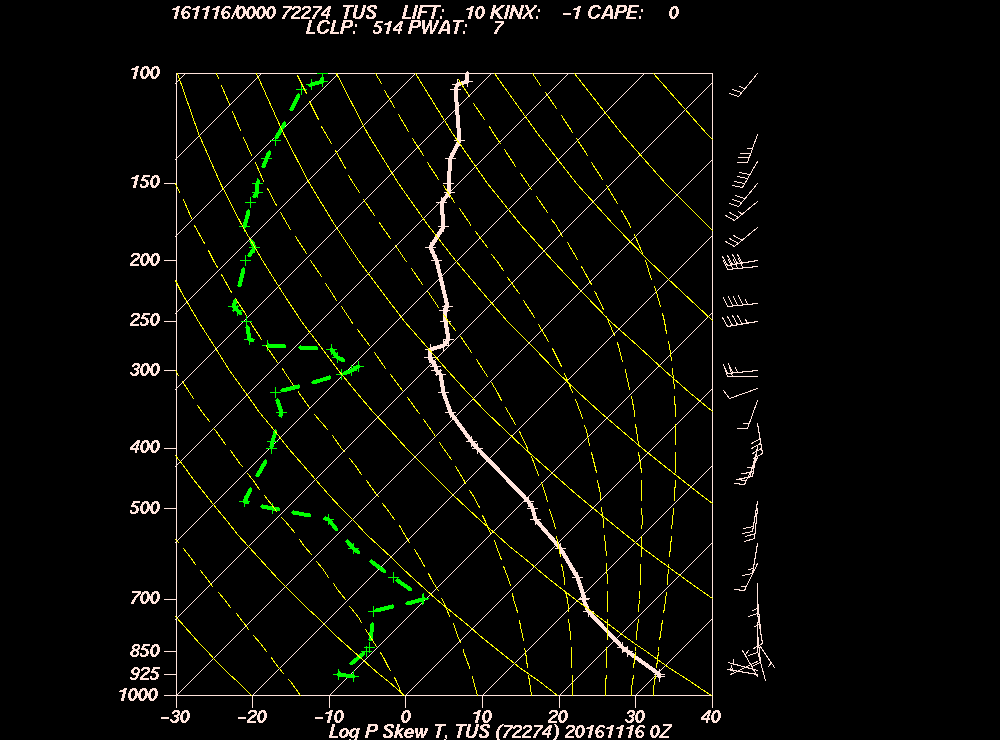
Rawinsonde balloon temperature and dewpoint profile near the time that it rained in clear air from the backside of our rainband. As you can see, cloud tops were around -10 C or a little cooler, pretty warm for raining clouds here. The main part of the rainband likely had somewhat cooler cloud tops. Thought you like to know. This sounding supports the idea that an ice multiplication process was at work, at least on the back shelf of these clouds that rained. I wanted to confirm prior ground speculations with more speculations from the sounding at rain time, though it was launched around 3:30 PM AST way over there by Davis Monthan Airbase. Wondering now if I will finish this blog today….4:34 PM. Shelf of rainband exits the Catalinas. Nice lighting, though.6:32 PM. While the rain may have washed a lot of dust out of the air, more dust invaded the area as soon as the rain ended.
..will be playing your favorite western tunes in the inimitable style of Johnny Cash at the Whistling Cactus Bar and Hitching Post this Friday and Saturday… :} (Hahahaha; “inimitable style of Johnny Cash”; that means Cash’s style can’t be imitated!)1
6:37 AM: I see now that there’s a lot more dust than last evening! Wow. Dusty Sunrise!
4:13 PM. Cumulus fractus. Dust is visible if you look hard on the horizon. The back scattering of sun light from dust aerosols makes them hard to detect looking away from the sun. But looking toward the sun, the sky has a whitish, gritty look as we had yesterday. When smoke aerosols are present, the sun can appear very orange or reddish, not white in the mid-day-afternoon hours. See the photo below, taken in the forward scattering direction, that whitish look near the sun. For those who want to go deeper, this. Images here.4:12 PM. Whitish, gritty dust exits Tucson and envelopes Mark Albright’s house in Marana/Continental Ranch, carried on a SE blast of wind from Texas and NM.
6:11 PM. Same view as above but most of the sun’s white light has been scattered out leaving the longer yellow and orange wavelengths to carry on.6:20 PM. Classic appearance of a dusty sunset.
Satellite image of aerosol content as seen from above (:}. Green area is the dust plume that appeared to originate in SW Texas and southern NM, then blew into Tucson town yesterday afternoon. Looks like its still here this morning. Go here to see more jpegs of aerosols.
Today’s mix of clouds and dust
Cloud action today, likely some small Cu and Ac later today as a weak upper level trough approaches and passes over us. Should be enough clouds around to pose a sprinkle threat. Imagine.
Should be an especially interesting day for cloud watchers since the dust aerosol should get into the small Cu. Sometimes that can lead to much larger cloud droplets in them because the dust particles are so much larger than the usual aerosol stuff that gets into our clouds.
What does that mean?
Will help those lower Cumulus clouds to form raindrops, since the larger the cloud droplet, the higher the temperatures at which ice forms. Sometimes, even drizzle drops, formed from just droplet collisions can result in Cu mediocris clouds with large dust particles in them (no ice involved). Would sure like to have an instrumented aircraft in the clouds of today!
Normally, ice would be expected to form at temperatures below about -10 to -12 C here in AZ. Today, it might be higher with virga falling from shallower clouds than usual.
The weather ahead
Found some rain for ya… March 21st. See those green areas in SE AZ? Been quiet on rain lately. Don’t like to talk about rain when there’s none indicated for two weeks at a time. The rain shown for us on the map above has been coming and going around this date in the model runs, mostly going, actually, but scored one here based on yesterday’s 5 PM AST global data and that has allowed me to take the rain muzzle off.
So….in sum, we can look forward to another chance of rain in March, one just ahead, and, of course, more of “Dusty Sunset” in the meantime leading up to this chance.
—————————
1Saw a vinyl record album with those EXACT words on it in the Durango Market on Main Street, Durango, back in the ’70s when I lived there. Pretty funny, because you KNEW that imitating Johnny Cash was exactly what that singer was going to do!
BTW, finally got a “submission” in late yesterday about our neat storm after what was deemed a power outage of some type affecting the hosting service yesterday. After re-reading it, perhaps I had too much time to think about it… Oh, well, onward.
First, from yesterday, a day with occasional sprinkles, dessert:
6:48 PM. Residual Stratocumulus and Altostratus translucidus from a cloudy, unusually cool April day.
The remarkable thing about yesterday, and you might have thought it was fog, was the amount of dust in the air after the rain and after the winds calmed down from those 50-60 mph blasts from yesterday. Well, it was plenty windy in the deserts behind the rainy frontal band and that dust-laden air moved in right after the front went by. At first glance, and since it had rained, I thought it might be fog! But a quick check of my senses and the relative humidity, which needs to be near 100%, showed that it was only around 60%, the measurement that demonstrated it could not POSSIBLY be fog. There you have it. Problem solving for you by C-M.
Here’s an example of that dust:
7:12 AM. The unusual sight of thick dust below Stratocumulus clouds and only hours after a substantial rain.
With cloud tops yesterday only having to reach to 11,000 feet above sea level to surpass the magical -10 C (14 F) temperature level, hardly much above Ms. Lemmon, ice and virga from these clouds was virtually guaranteed. And, if you were watching, there was plenty, including from those clouds we couldn’t really see so well due to dust, ones that produced those several morning and early afternoon sprinkles (“its not drizzle”, a continuing theme here. Only a meteorological ignoramus would call a fall of isolated drops, “drizzle” (or snow and rain mixed together “sleet”). Perhaps I am too strong here, but it is important to get it right since REAL drizzle and sleet (raindrops that freeze on their way down through a shallow cold layer) tell you important things about the clouds and layering of the air overhead. Here are some of yesterday’s clouds as the dust thinned (both due to mixing upward into a greater depth, and due to clearer air moving in):
9:09 AM. The dust remains, but the Stratocu is mostly gone. Twin Peaks still not visible from Catalina.10:13 AM. Dust lifts as Cumulus arise on the Catalina Mountains. Nice view of “Catalina Heights” manufactured home country, too, where C-M lives.12:20 PM. By mid-day, quite a few of the highest tops of the Cumulus-Stratocumulus complexes had likely surpassed the -10 C level, probably much lower, to -15 C or lower temperatures, and scattered virga and snowshowers were aplenty in the afternoon.3:20 PM. By this time cloud tops had descended, weren’t so cold, and those Cumulus and Stratocumulus clouds just kind of sat around not doing much but making pretty shadows on the Catalinas.
By mid-afternoon, most of the deeper clouds with substantial virga were gone. You can see what happened in the mid-afternoon here in the U of AZ time lapse movie (as well as the thinning of the dust haze we had yesterday) here.
The weather ahead
No rain has popped now in the mods for some time regarding the passage of a trough on the 17th, just some wind with it, though not anywhere like what we just had. In the drought relief department, it was another great day yesterday for portions of KS and NE as shown in the WSI Intellicast radar-derived precip map:
The 24 h precip totals for the US ending at 5 AM AST this morning.
Of course, the title refers to Dickens’ little known sequel (and frankly, a lightly regarded one) to his popular, “Great Expectations”. Dickens fully expected that by rushing out another novel similar to “Expectations” that a financial success similar to the one that “Expectations” had garnered for him would be easily acheived.
However, like most sequels, his effort was weak and appeared to be thrown together to merely take advantage of a gullible public. However, and much later, his sequel came to be regarded as a semi-clever, though lightly disguised, slam on the early English weather forecasting system, which was, of course in those days, was map-less, model-less, and mainly consisted of limericks and folk sayings:
“Birds flying low; beware the Low1.”
Forecasts were quite bad in those days in which Dickens lived, naturally, ships went down regularly due to unforecast storms, and Dickens wanted to dramatize this to his readers in his sequel; the various twists and turns in the plot of that sequel now thought represent ever changing, unreliable forecasts. He had hoped, with his satirical sequel, to provoke advances in weather forecasting, which he did. Isaac Newton, joined by Leibnitz, took wind of the Dickens sequel, and together they invented calculus, a tool which which allowed the calculation of the movement of air using the laws of fluid dynamics.
—-End of historical antedote2——————————
A surprising overnight rain
Well, even C-M and associated models like the Beowulf Cluster as of the 5 AM AST run on the 8th, did NOT see 0.38 inches from “Joe Cold Front”, who was supposed to pass by as a dry front, not a wet one. Still, it was fantastic surprise, one that could have only been made better by having forecasted it from this keyboard; going against the models big time. And THEN to hear Joe’s rains pounding on the roof as he went by between 10 PM and midnight. Oh, my, euphoria. BTW, the temperature dropped from 60 F to 43 F, too. Whatafront! Thank YOU, Joe.
You can see some rainfall totals from the Pima County ALERT gages (April 8th-9th rainfall). We “northenders” pretty much got the bulk of it, with Pig Spring, 1.1 miles northeast of Charoleau Gap leading the way with great 0.71 inches. Ms. Lemmon was not reporting at this time because it fell as snow. So look for a frosty Lemmon this morning. BTW, Sutherland Heights picked up 0.42 inches, and had “pre-rain” gusts to 58 mph! Whatastorm!
Continuing now at 7:21 AM after a “godaddy.com”/Wordpress meltdown an hour ago.
BTW, all the haze out there is dust under the clouds, not fog. Its pretty unusual to see something like this, especially after a good rain, so you’ll want to document it with photos and a little paragraph or two about it, and how it makes you feel. There was so much dust raised behind Joe throughout AZ and Cal that its rainband could only do away with that dust within it. This overcast situation should gradually breakup as the day goes on into more cumuliform clouds, ones with large breaks between them, the dust probably hanging on most of the day. With the -10 C level, the usual ice-forming level here at just around 11,000 feet above sea level. So it should be easy for the taller Cu to reach that and spit out some isolated precip later in the day.
Signs that the forecasts were going bad in a major way was when lines of clouds and some with precip formed in southwest Arizona late yesterday afternoon. Here’s a nice map of that development, one in which caused the tiny brain of C-M to think that it might rain, probably you, too, and anyone else that looked.
5:30 PM AST visible satellite image from the U of WA.5 PM AST 500 millibar map. You can just see that little line of clouds, and you can also see how the jet, wrapping around San Diego and headed this way, partitions the clouds. I think this is called a “teachable moment.”
Some scenes from yesterday’s dust, from the beginning. Save these for posterity:
8:21 AM. No sign of dust.1:47 PM. Dust haze becoming increasingly noticeable.2:00 PM sharp. Mr. Cloud Maven person’s cap blows off about 40 yards down the road in spite of having warned others about having this happen.2:04 PM. Dust increasing rapidly, wind peaking at 55-60 mph in the Sutherland Heights district. Twin Peaks no longer visible.3:02 PM. Small Cumulus (humilis and fractus) increase in coverage as dust limits visibility to around 10 miles.6:38 PM. The yellow sunset, indicative of large aerosol particles associated with dust.
————————–
Feeling good about rain here, feeling good about rain there
Not only can we exult over a surprise rain of some substance, but look what has been happening in the droughty central Plains States. Below, from WSI Intellicast’s 24 h radar-derived rainfall amounts for the US (april 8th, then April 9th at 5 AM AST. Especially take stock of the amounts over the past two days in those worst drought areas of Kansas and Nebraska. So great! And this is only the beginning of a huge rain/snow event in those drought areas!
24 h rainfall ending at 5 AM AST April 8th.
The End
—————————————————
1Hygroscopic insects adsorb water molecules and are weighed down in conditions of excess humidity, the kind that often precedes a storm. Birds then fly lower, too, to grab lower flying insects, or so the saying goes. (I am quite pleased by the kind of information I provide for you almost everyday.)
There’s the “artichoke capital of the world” in Castroville, CA, but here in Catalina we’ll the “wind capital” of all of North America tomorrow afternoon. Its great to be the “capital” of something, anything! Thought you would like to know about the wind, maybe glue on your baseball cap in preparation for extreme winds tomorrow, especially later in the day just before “Joe Cold Front” arrives with his blustery blasts from the west and northwest tomorrow evening and overnight.
No rain in “Joe”, but during the following couple of days as the unusually cold air for April makes itself at home here, we’ll probably see some Cu with ice (tops colder than -10 C, to continue a refrain here), and that could mean enough virga for a sprinkle at the ground here. Likely some measurable snow on Ms. Lemmon during that time.
Here’s what happens as rendered by IPS MeteoStar, these cool looking wind maps for tomorrow. Not much to begin day at dawn, then “pow” by mid-late morning:, then wind reaching a crescendo (a great word, you can feel it) during the mid and late afternoon. Gusts likely to better 50 mph in brief puffs here in Catalinaland.
Valid at 5 AM AST. No wind here yet, mod sez.Sun ignites ground wind machine by 11 AM AST tomorrow. Dust raised to our southwest by 25-30 kt steady winds likely to invade area during late morning and early afternoon, gradually thickening. Horizontal visibility may be less than 10 miles, which is unusual for here.
Valid at 5 PM AST, tomorrow April 8th. Gust here in Catalina, likely to exceed 50 mph. Hang on to your hat and toupee, likely need a lot of hair gel if you don’t hat up. And, park your car on the south side of tall trees.
9:42 AM: Small Cumulus clouds first appeared over the Catalinas within a half hour of this shot.
These small fluffs of Cumulus clouds above Ms. Mt. Sara Lemmon, were the first indications that something good, and very different from the previous two days was going to happen yesterday. These clouds appeared no less than 4 h earlier in the day (between 9 and 10 AM yesterday) than those first Cumulus on top of the Catalinas on the previous two days.
The correct emotional response due to this early rising for cloud maven juniors and doscents out there should have been excitement and anticipation; that some big boys with long names (Cumulonimbus capillatus incus) were likely going to be around later in the afternoon and evening hours. No weather maps needed! See AZ Star for confirmation.
While we didn’t get a big dump right here in Catalina, we did at least get a dust-coagulating 0.02 inches. Here are the totals ending at 24 h from around the region from the Pima County Alert gages. The most hereabouts was at the Santa Cruz River at Ina Road with 0.59 inches, with that storm shown in the photo at 4:25 PM below.
Today, with dewpoints once again being in the upper 50s, it should be the case that we see these early precursor clouds on top of Mt. Lemmon, and they will once again lead to the conclusion of a satisfying day of thunder and intense rainshafts, driven by 100 F plus temperatures. It peaked at 106 F here yesterday in Catalina, and it was fairly cloudy when that temperature was recorded! Pretty remarkable.
Here are some later shots of those great clouds, and if you want the whole nine yards, go to the U of A time lapse movie here. There’s a lot of rotation at the bottom of some clouds 1:03 before the movie finishes, and an indication of a rope-like funnel cloud, not too surprising given the instability of yesterday.
1:42 PM: Able to hear thunder for first time.3:24 PM: Cumulus clouds begin piling up over Catalina.4:23 PM. Eventually of those Cumulus congestus clouds reached ice-forming heights and produced our little 2 hundredths shower. By the time it reached Saddlebrooke, it had a visible shaft.
4:25 PM: While our little shower passed by, Marana and vicinity were getting the real thing in dumps of more than half an inch.5:18 PM. Ditto to the NW where heavy rainshafts in this complex created a “haboob” that affected Casa Grande.5:25 AM this morning: Stratoumulus with Cirrus and Altocumulus above greet the morning sunrise.
Maybe today, with plenty of clouds and heat, it will be our day to get the big dump and wash the dust off our desert plants.
In MINUTES, the temperature will head downward as our long foretold (remember the spaghetti plots?) , “dusty cool snap” finally arrives. This time, from Intellicast, you can see below the blob coming, that blob of much lower temperatures with an epicenter at Las Vegas. Unfortunately, there are few clouds with this system, oh, maybe enough for a scruff over the Catalina’s a little later this morning and in the afternoon, Cumulis humilis, that sort of thing, and THEN we’ll get some nice cloud shadows on the mountains for awhile.
If you have a barometer, though, you will get to enjoy the “pressure check”, that sudden, sharp rise in pressure as the air over the barometer gets cooler and denser, mashes down on it more as the cold front goes by! You could be informing your neighbors about it. (Actually, “on further review”, with the temperature in descent now (5:18 AM), and barometer on the rise, I think the cold front has gone by already. )
BTW, while its windy here in Catalina right now, down in Tucson, they’re only reporting 7 knots, no gusts. This is kind of usual for this situation for us to get the brunt of the winds funneling up the Oro Valley while TUS is protected for the time being.
Still enough wind/pressure gradients around for dust today, but those gusty winds should really be gone by tonight and tomorrow in Catalina as that deep low, still in the Great Basin fades. See below for a neat looking weather map from where else, the University of Washington. In case you want to see more maps, go here.
Feels great to be in the circulation of a big low, that one centered in Utah right now (5 AM AST. People all around the country are probably talking about us and all the weather we’re having hereabouts, at least the ones watching The Weather Channel.
Not much ahead to talk about, just a few very pleasant clear days and rising temperatures.
HOWEVER, updating here at 6:11 AM, and having just checked the NOAA spaghetti factory, it does appear, but with moderate confidence, that another dusty cool snap is ahead for 11-12 days from now in a pattern remarkably like the current one with a “Big Trough” along the West Coast again. That event would center around June 7th plus or minus a day or so. It will be fun to keep an eye on this every coupla days.


