When Seattle Mariners’ pitching coach, Frank Funk, called me in from the bullpen that Sunday in July 1981, I was pretty nervous. I had never before pitched to major league batters. Tommy Davis, the former Dodger outfielder, had been nice enough to warm me up in the bullpen instead of one of the Mariners catchers. I strolled onto the mound, heart pounding. I had played at this University of Washington Husky campus venue, Graves Field, where the Husky baseball team played, many times as a member of Seattle’s“ Paintings Unlimited” semipro summer team in the Western International League. Still, the whole scenario of the Graves Field filled with major league players just after the 1981 baseball strike had ended, was surreal.
Since I didn’t follow major league baseball at all, I had no idea who the first batter I was to pitch to was, his gray hair protruding from his Seattle Mariners’ cap. I thought he might be a coach just to check me out before the actual players stepped in. I began throwing in as machine-like mode as I could, one ball after another; no dawdling is permitted. And I had velocity; the ball did not arch but zipped in. I estimate that it was in the mid-60s to maybe 70 mph. It was exactly as I threw BP to my semi-pro team before our games.
Somehow, I got into a rhythm in spite of my nervousness, and it was one strike after another. And I was giving up a lot of solid line drives and bombs. After that old guy with the gray hair sticking out from under his cap finished, then came Lenny Randle, Gary Gray, Julio Cruz, Bruce Bochte, and a couple of others. Gray, who was having a great start until the major league baseball strike, hit quite a few out. That whole 1981 Mariners roster is here.
Later, I found out who that gray-haired batter was; it turned out to be Tom Paciorek, the player who was leading the American League in hitting when I threw to him! Honestly, I had no idea who he was.
After my BP stint at Husky Ballpark that day I got a lot of positive statements from the players, “sweet BP”, high fives, and such. I was told by Coach Funk that they would call me down to the Kingdome when the games resumed. Of course, I could never be sure that it would really happen; maybe they were just being nice.
But, in any event, whether they did or not, I had a witness that day. My good friend and grad student in our Cloud and Aerosol Research Group, Steve Rutledge with whom I played catch with regularly at the University of Washington, was there at Husky ballpark that Saturday afternoon, and saw the whole “drama” unfold.
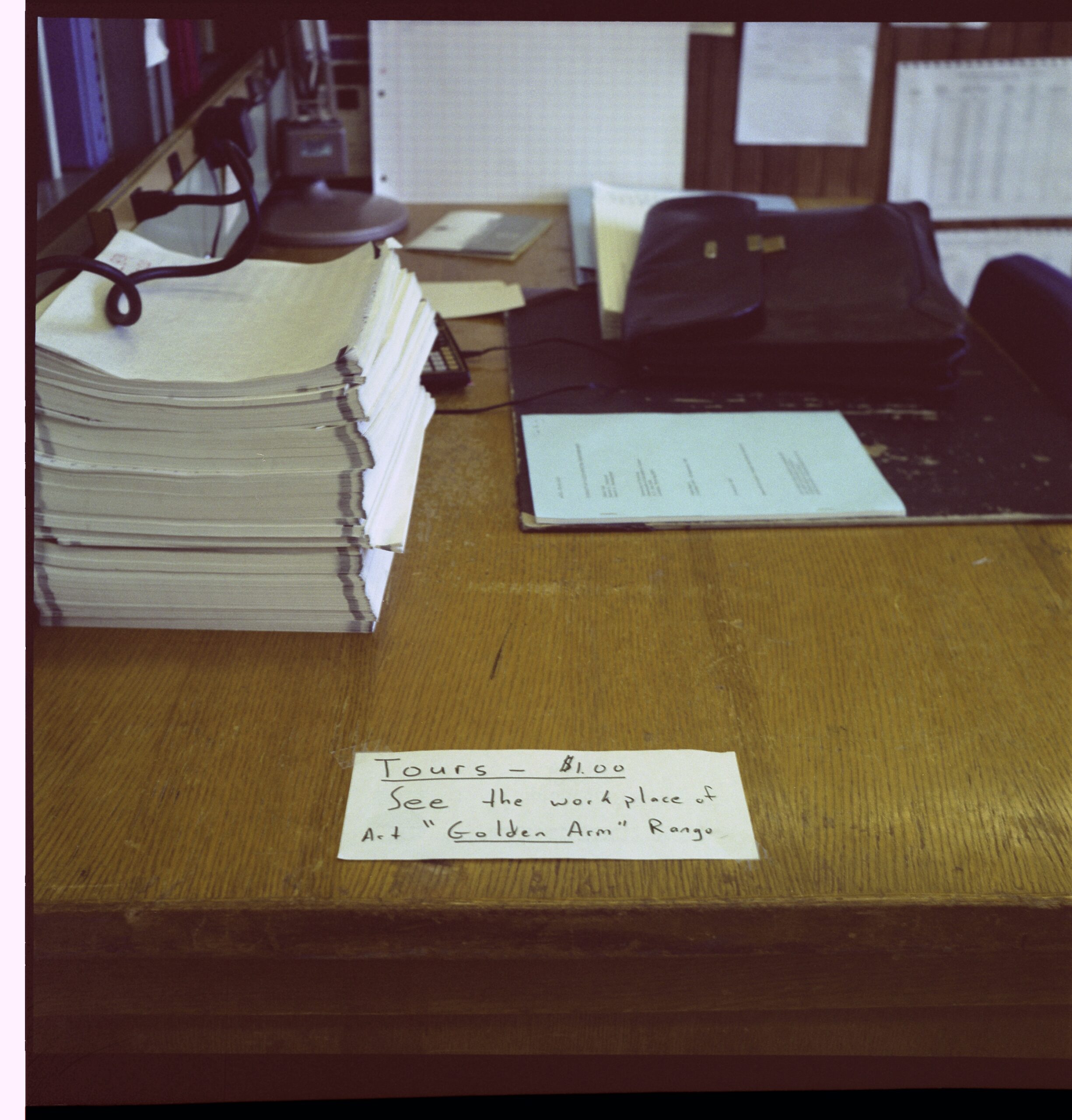
The next day, to my surprise, there was a tiny mention of “my work” in the Seattle Times. And, to top it off, Dave Parsons, another graduate student in our group had seen that little Seattle Times note and pasted it on my desk at the U-Dub, along with a little sign that read that there would be a “$1 charge for touring the desk of Art ‘Golden Arm’ Rangno.” It was pretty funny. An awful lot of guys can throw BP, but to my co-workers and grad students in the department, it was something special.
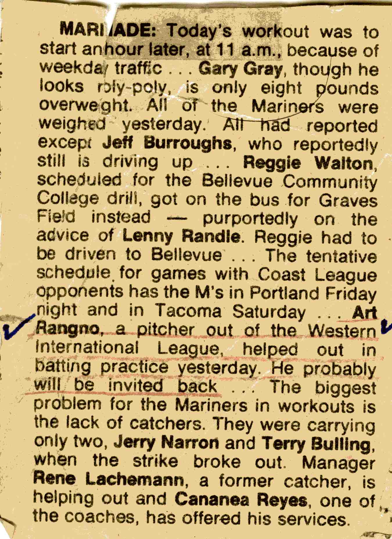
A few days later the 1981 baseball season resumed its abbreviated schedule, and while I was at work, I “got the call” to join the major league team—as a batting practice pitcher!
It was pretty exciting since my desire for throwing BP was really just to see how different a major league team was in hitting a baseball compared to my own Seattle Paintings Unlimited team for whom I pitched BP to regularly. I liked to throw BP with velocity, and my team loved it.
“Regularly” meant throwing a LOT of BP, too! In the Western International League (WIL) that we played in, there were four-nine-inning games a week beginning in June and continuing through mid-August. The WIL was a league comprised of a sprinkling of ex-pros and summer college teams, like the Washington Huskies (sans seniors). One stalwart to play briefly in that summer league decades later (later renamed, the Pacific International League) was former Giant star, Tim Lincecum.
That Paintings Unlimited team had a regular supply of pro baseball signees: eight were signed from that one team during my 5-year tenure on it, including several that made the major leagues, if only for “a cup of coffee.” One was Mike Kinnunen, a Washington State pitching star, who, the very next year after his 1979 season with Paintings, was pitching for the Minnesota Twins and against the likes of Don Mattingly! In 1980, I was batting cleanup, and the hitter before me, Jay Erdahl, was to make the last out at the College World Series in Omaha that year as his “Cinderella team,” the Hawai’i Rainbow Warriors, lost to the Arizona Wildcats.
It was a heady time playing on that Seattle north end team.
https://cloud-maven.com/wp-content/uploads/2021/06/Northend-Semi-Pro-team-026.pdf
But by 1981, at 39 years of age, and competing against area college players, I wasn’t playing anymore. For all the years that I played beginning in 1977, I had been the oldest starting player in the league and was always vulnerable. Not playing anymore in 1981, riding the bench, warming up pitchers, meant I was hungry to do something more with a baseball. And it was that summer that I read that the Mariners, following the end of the baseball strike of 1981, would begin working out at the University of Washington where I worked. And I took a chance and went out for a tryout as a BP pitcher.
——————————————————————————–
The Mariners were pretty bad during my stint as a BP pitcher, 1981-1983 under poor manager, Rene Lachemann. Lachemann was fired during the 1983 season, and before he was fired, as you can imagine, he was under intense media scrutiny and pummeled with advice.
Lachemann ran around the perimeter of the outfield before the Mariners games, and being out there myself during BP, I yelled to him just before he was let go:
“Hey, Rene….about the team….” At this point he turned toward me, one of his BP pitchers, with the darkest scowl you can imagine. I continued, with a smile: “I don’t have any advice about the team.” Lachemann broke up in laughter, and that moment still comprises one of my fondest memories.
Another memorable moment was pitching to just two batters, Paciorek and Bochte for my whole 20-25-minute stint. The reason? They thought my delivery resembled that of Jim Palmer and the Mariners were playing the Baltimore Orioles that night with Palmer pitching. Paciorek and Bochte together got five hits that night!
Then, in 1984, I was “released” by Del Crandall, the new Mariners manager. Instead of having local amateurs come in and pitch, the team would now use its coaches almost exclusively for BP, with I think, one exception, Jerry Fitzgerald, a fellow “volunteer” BP pitcher who was a lefty. Lefties are always in demand!
But there was another factor that led to my “release” in 1984, one that came out of the blue, a factor that was hard for me to believe.
In one 1983 BP session later in the season at the Kingdome, Steve Gordon, the Mariners bullpen catcher in those days, caught me. Usually you just threw at the netting behind home plate. At one point while I was throwing, Steve raised his right arm in a throwing motion and waved it at me several times, using an overhand motion. Since I was throwing one strike after another with “velocity,” I thought he was signaling to me about how great I was throwing.
Nope.
When my session was over, Steve came over to me and said, “The guys are getting pissed because you’re cutting the ball.”
“Cutting” the ball in baseball meant that you are throwing a ball that had movement; it was not going on a straight line which makes it eminently hittable.
I was flabbergasted, and felt truly bad, since as an amateur pitcher from time to time, I never was accused of throwing a ball with movement, a downfall for anyone that wants to pitch. It was so ironic that I was now being told that my ball had “movement!”
I also began to realize that I wasn’t giving up many home runs while throwing BP. The fun part for the players is to just blast the ball as friggin’ far or as hard as they could; it made them feel good, get confidence, and that wasn’t happening. Richie Zisk, the Mariners slugger of the day, once told me I had “the best sinker in the league”, but he was SURELY joking, maybe even being sarcastic I thought. I forgot about it.
I began to think about some other not-so-great things that had happened in 1983. One HUGELY embarrassing thing for a BP pitcher had happened during my session pitching to the struggling Al Cowens; he swung and missed a batting practice pitch! My face turned red and I kind of apologized, muttering a “sorry” to him. Then, he broke his bat on another pitch. I felt horrible! But I didn’t think I had anything to do with it; he was in mental funk about hitting that season and nothing could be hit properly.
Another dismal chapter (travesty?) in 1983 involved Gaylord Perry, a good hitting Hall of Fame pitcher. He stepped into the batter’s box during BP wanting to crush a few just for fun—pitchers don’t bat in the American League. After a few swings and misses, and foul balls, he quit in disgust yelling at me, “That’s terrible!” I never forgot his comment.
I only wish I had been fast enough to add, “Hey, I was just putting goop on the ball like you did all those years to see how you liked it, you washed up buffoon.”
Perry was a well-known spitball pitcher who amassed many of his 300 wins in a dishonest way, but one in which baseball generally looked the other way. In a 1982 weather forecast I made for KZAM-FM, I alluded to the Perry “methodology.” My housemate, Yuko, recorded it, something that may be a candidate for the media weather forecasting “Hall of Shame.” it’s a little muffled. The DJ, Dave Scott, chats for about 25 s before I come on with my forecasting travesty “honoring” Gaylord:
https://cloud-maven.com/wp-content/uploads/2021/07/moisture-and-rotation.mp3
In my defense of this so-called, “schtick” presentation of weather, let us remember that in 1981, the weather forecast methodology was described by the LA Times as consisting of “Clowns and Computers.” I did my best to fit in!
Later, and in trying to be analytical about “movement” on the ball, I thought that maybe my sweaty hand—I was always nervous stepping out on the Kingdome mound, had maybe caused that movement that I did not mean to have.
And you were always throwing almost brand-new baseballs from the basket of balls next to you that held about 40 of them. Those new balls had no roughness, so you had to be careful throwing them, making sure you had a good grip. Maybe I was gripping them too tightly?
I did not move up from the pitching rubber like the other BP pitchers did. I threw from the mound like a regular pitcher (and behind the protective screen), as I did for my semipro team. I never changed that style. I was not throwing anywhere near the speed of major league fastball, of course. But maybe that extra distance gave the ball more time to move. I never discovered what caused the movement.
Other things that happened….
Three non-strikes in a row happened a couple of times, and the quiet, that lack of a ball being struck virtually every second, is really unsettling. The whole Kingdome seemed to go silent at such moments. They were rare, but they did happen.
If that wasn’t bad enough, during a 1983 BP session, I hit a Mariners batter in the knee, starting centerfielder, Joe Simpson. There was an audible “oohhh” from the tiny early arriving Kingdome crowd.
On another major slip, I made Dave Henderson come out of his helmet when a pitch I threw got away high and inside causing him to drop to the ground.
You know, I am sounding more and more like a really bad BP pitcher!
If your wondering, only one batter on one occasion asked to practice hitting against curve balls in BP, John Moses, a Mariners center fielder.
An important fact: in 1983 the Seattle Mariners had the 2nd lowest MLB team batting average at 0.240. No doubt this contributed to what happened next.
So, when I showed up in the locker room for the start of the next season in 1984 with the “guys”, I was given the word that my services were no longer needed. I left the locker room kind of embarrassed, passing the security guard I had just said “hello” to, hopped on my bicycle, and rode home. Yep, I peddled every time to the Kingdome from the U of Washington, and then home to north Seattle’s Greenwood neighborhood, probably a good 10 miles total, and with slopes and in traffic. It was a great warmup coming in.
I remember, too, in those simpler days, how easy it was to get in the locker room of the Seattle Mariners with my little bag of equipment, by just saying to the security folks, “BP”. Of course, after a couple of times they recognized you and in you went to join the “guys.”
It was fun to do that BP, too, because unlike the other BP pitchers, and before I pitched my 20 minutes or so, I ran around in the Kingdome outfield like a mad man chasing those balls hit in batting practice—I played outfield in my early amateur career and this was outfield practice.
A couple of times, too, when a player found out I was a meteorologist at the University of Washington, we would stand around in the outfield during BP and talk weather. I remember a long conversation with Richie Zisk out there about El Ninos, a giant, headline-grabbing one having happened that 1982-83 winter. He really asked a LOT of questions.
If you were here in Catalina, AZ, in 1982-83, you would remember that giant El Nino year. In that water year (Oct-Sept) we received over 29 inches of rain, and 33 inches if you count the first few days of October 1983 when the worst weather disaster in Tucson history struck due to several days of heavy rains on already saturated soil at the beginning of October.
Back to baseball…
It may seem odd, but I could hardly stand watching a major league game even in the stands right behind home plate. As a player, playing with top amateur talent, the last thing you wanted to do was sit on your butt and watch other guys play! You wanted to be playing against the BEST yourself.
So, while my Mariners BP “pay” was to sign in for four free tickets amid the players’ wives behind home plate, I only went to one game for a few innings during those three seasons I pitched BP. I usually gave my tickets away by signing in the names of folks from the U of WA Atmospheric Sciences Department where I worked on the guest ticket list before I left.
While I many of those great seats were used by folks in our Department, the Mariners were so bad in those days (1981-1983), that on MANY occasions I could not GIVE away the best seats at a MLB game, the ones right behind home plate!
After a while, I didn’t make much of an effort since it was kind of embarrassing to be turned down two or three times by my co-workers and grad students. Almost as bad as being turned down two or three times for a date by the same girl.
The Mariners played music on the Kingdome sound system during BP. One particular piece, a Beatles disco-style medley by “Stars on Long Play” that sounded exactly like the Beatles, was played repeatedly during the time I pitched:
To this day, hearing this, if I do, puts me back in the Kingdome on the mound with a basket of baseballs next to me.
I realized I could have pitched BP for many years if I had pitched the way the other BP pitchers did; closer to home plate, off the mound, lobbing the ball at fairly low speeds. I was arrogant to think that the way I liked BP to be thrown to myself, balls with some zip, was the way to do it for MLB batters. It seemed OK at the start until the ball started to “move.”
Well, that’s all I can remember right now, but it’s already too much.


