After re-thinking the powerful storm yesterday based on the morning’s new data and making it a semi-marginal one, most of the rain to the south, the Canadian model run came back last night with a powerful AZ storm again! Forecasters who want lots of rain here in AZ and Catalina can get manic-depressive during these fluctuating model outputs. The fluctuations in the PREDICTED intensity of the storm tell us that all is not known well upstream.
Below is what transpired in this, “pretty good” Canadian model beginning with yesterday’s “retraction” (first panel below) after predicting the mammoth storm over all of AZ this weekend just 12 h earlier. Note in this panel, valid for Sunday morning, how little flow there is over AZ (indicated by very few “lines” or as we would call them, “contours”) compared to the run the night before (which I excitedly displayed here)! Pitiful change. In this first panel, upper left, we’re between two jets, the one looping around the low off Baja and the one across the northern Rockies. Not good. You need flowmax to help squeeze winter moisture out of the clouds as they bang up against our mountains. And with flow, you get better overall rising motions, the kind that creates vast areas of deep clouds and rain. We don’t got that in this first map, and you can see the heavier precip (yellowish areas) are mostly S of the border.
So, a disappointing sight, but in view of the sudden appearance of a giant storm from nowhere in the models (suggesting an error), not an unexpected “retraction” as was mentioned in yesterday’s blog.  But, that “giant storm model run”, 24 h ago did see SOMETHING.
Why do I know?
Because the latest global data (from last evening), has increased the strength of the storm hitting us to something major in all of AZ. Check the areas of precip in the next two panels from last night, hot off the press, for this Saturday and Sunday.
Also the timing of the AZ precip is drastically different in these two runs just 12 h apart. Last night’s run brings the major storm in on Saturday and continues precip into Sunday, while the run just 12 h before that has a DRY Saturday in all of AZ! Quite remarkable changes from global observations just 12 h apart. Look, too, and how the flow over us (upper left panel, and marked by more “lines” over AZ) is so much stronger in these latest predictions compared with the flow predicted just 12 h earlier (upper left panel in the first image).
So, what does a weatherman do? Personally, since I like rain in Arizona, I go with the new model output completely. But a real weatherman, one that is a little more objective (BTW, not an objectionable one) would play down the storm and think about “spaghetti”, not food, but plots that is. “Are the models “converging” to a better storm or not?”, he would ask himself. Not me. Do small tweaks still lead to huge differences in the amount jet stream over us, predicted rain, etc.?
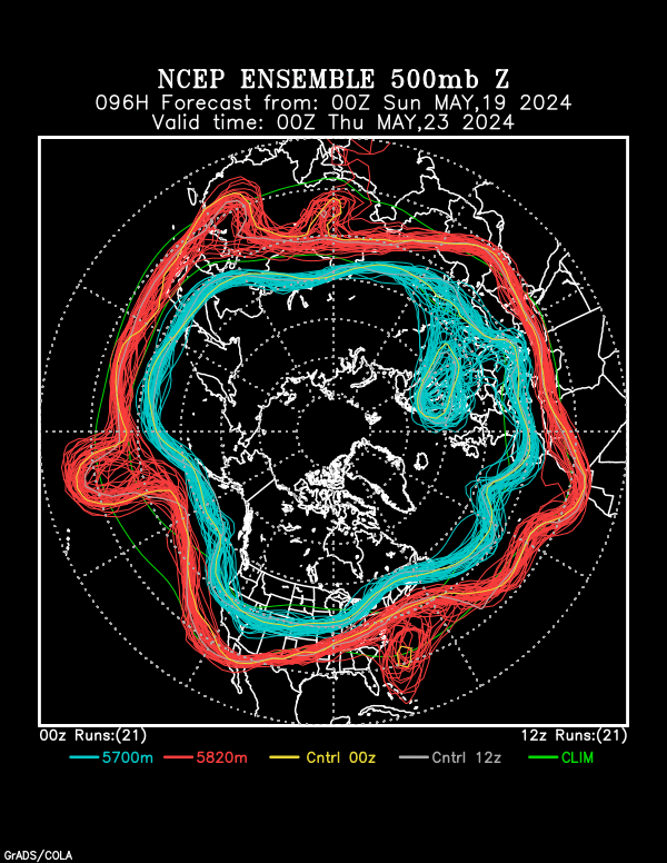
Last, an example of a northern hemisphere “spaghetti” plot for model predictions for this Saturday, a plot that we all use that clearly shows the models are clueless (well, at least erratic) in their predictions for the West Coast and Southwest. That “cluelessness” is indicated by the “bowl of rubber bands” appearance of the lines off the West Coast and over the Southwest. Where the lines are on top of each other is where there is little chance the prediction will go awry. Where there is a “bowl of rubber bands” there is tremendous uncertainty.
So, the spaghetti plot is showing that here in AZ, its possible to have either significant rain with some flooding with this storm over the weekend, or a just a little light rain. If you like spaghetti, you can go here and see a bunch of them. Enjoy the uncertainty. Its a little like the rest of life. Me, I’m preparing for a lot of rain over the weekend. I want to see the Sutherland Wash flowing!
The End.


