-
-
- The background for the trip to Israel: The British, among other groups, can’t get in to study the ripe-for-seeding clouds in Israel
- The British can’t get in: Sir John Mason’s letter
- Why I thought I could do something
- Story board concerning a trip to Israel to see their clouds
- About the clouds I was supposed to see in Israel
- 1983, an early jab at “faulty towers”; a paper that questioned the Israeli experimenters’ cloud reports is submitted and rejected
- About getting the 1986 cloud study published
- The best example of rapidly glaciating clouds I saw
- Why was the 1986 study submitted to a foreign journal?
-
1. The background for going to Israel in 1986: no one could get a research plane in to check out those ripe-for-seeding clouds described by the experimenters
By the early 1980s, the events in the journal literature I had experienced during the 1970s caused me never again to believe in a cloud seeding success prima facie no matter how highly regarded it was by national panels and individual experts, as the Israeli experiments were in those days. In Part I, I discussed what happened to me in Durango, a transformation from a pretty naive, idealistic person “going in”, to one that knew those experts alluded to above could be easily fooled and were more naive than I was starting out! Just too much resting on the reporting a cloud seeding success; glory, funding, status, confirmation of a priori beliefs, for a “let the chips fall where they may” attitude.
The ripe-for-seeding clouds that I went to see in Israel were ones that the HUJ scientists described repeatedly in journals and in conference presentations. They were the foundation for the belief that seeding them had resulted in statistically-significant increases in rainfall that reported in two, separate randomized cloud seeding experiments, Israel-1 and Israel-2. Those experimenters’ cloud reports explained to the scientific community WHY cloud seeding had worked in Israel and not elsewhere. These first two Israeli experiments were hailed by the scientific community, and in 1982 after the second experiment were described in Science magazine as the ONLY experiments in 35 years of seeding trials that had proven rain increases had been induced by cloud seeding. (Yes, there was a dreaded scientific consensus that these experiments had proved cloud seeding.)
At the time I went to Israel in 1986, and some of the reason for going, was that no major outside research institution, curious about those Israeli clouds, had been able to get their research planes in to check them out. At least six attempts had been rebuffed (Prof. Gabor Vali, University of Wyoming, personal communication, 1986). The attached letter below from Sir John Mason, former head of the British Royal Society and author of, “The Physics of Clouds,” wrote to me about his attempt to get the British research aircraft into Israel and coordinate such a mission with the lead Israeli cloud seeding experimenter, Professor A. Gagin (hereafter, Prof. AG) of the HUJ. You will find it illuminating about why outside researchers couldn’t get in.
2. British unable to get in
Why I thought I could do something
So, in going to Israel in 1986 and by then having ten years of experience under my belt in airborne cloud studies with the University of Washington’s Cloud and Aerosol Research Group (CARG), as a weather forecaster, as a former storm chaser (summer thunderstorms in the deserts of Southern California and Arizona, Hurricane Carla) and importantly, as a cloud photographer, I felt I could fill a vacuum left by those rebuffed airborne research missions. Peter Hobbs, the director of our group, put it this way: “No one’s been able to get a plane in there.” It was a very curious situation in itself.
3, Story board concerning my trip and its results
(Hit the expand button in the lower right hand corner for a full view.)
But Peter Hobbs also chided me before just before I went to Israel about my skepticism of the Israeli cloud reports; that I seemed to be indicating to him that I knew more about the clouds of Israel than those who studied them in their backyard. He also added that he thought I was “arrogant.” Wow. Peter, too, was still mad at me for resigning from his group just before a big project and raising a ruckus about it. Moreover, I had scrutinized the HUJ cloud reports in considerable detail, and had submitted a paper on the problems with them in 1983. I had a solid background for my assessment.
Why I resigned from a job I loved, is another long story (oh, not really; you know, it was the old “authorship/credit issue”). But it’s one that ends happily with a reconciliation a couple of years later, which doesn’t always happen! We both benefitted from that reconciliation. We needed each other.
My trip to Israel was self-funded and self-initiated. It may sound ludicrous, but I also felt that by going to Israel I was going to be able to do what those rebuffed airborne missions could not do; evaluate the clouds of Israel sans aircraft. I had flown in hundreds if not thousands of clouds using high-end instrumentation, and when you’re directing research flights as I did for the U of WA research group on studies of ice-in-clouds, mostly Cumulus and small Cumulonimbus ones, you visually assess clouds before going into them and then fly into them sampling the best parts and then see what your instruments have told you about them (concentrations of drops and ice particles, etc.). You get a real quantitative feel for how much ice they’re going to have in them by their external appearance.
So, by just visually assessing the Israeli clouds and estimating their thicknesses and top heights, I would know from my airborne work and background whether the reports about the ripe-for-seeding clouds were correct. Upon closer inspection, there were several odd aspects in the Israeli experimenters’ cloud reports.
Too, if I was right about the clouds of Israel, that they were starting to rain when they were relatively shallow (highly efficient in forming rain, as we would say), say, topping out at 3-4 km (roughly 10 kft to 14 kft) above sea level, the Israeli people might well be wasting millions of dollars over the years by trying to increase runoff into their primary fresh water source, the Sea of Galilee (aka, Lake Kinneret) by seeding unsuitable clouds. They had started a commercial-style program in 1975 after Israel-2, the second experiment, had been reported as a success in increasing rain.
During the first daylight hours of the first showery day I saw, shallow Cumulonimbus clouds full of ice were rolling in from the Mediterranean to Tel Aviv, ones that had been preceded by true drizzle and thick misty rain in Jerusalem the night before. I KNEW that soon that the cloud reports from the HUJ experimenters were grossly in error. Drizzle, btw, was not supposed to fall from Israeli clouds because they were too polluted. Drizzle, instead, meant they were ripe to produce ice at temperatures only a little below freezing due to having large cloud droplets capable of coalescing into bigger drops.
Of course, there were other experienced research flight scientists in cloud studies out there I am sure that could have done the same thing as I did. But, I was the one that went. (Spent a lotta money doing what I thought was an altruistic act, too.)
4. About the clouds I was supposed to see in Israel
So, what are clouds that are plump with seeding potential supposed to be like? Just that; fat and pretty tall. The clouds that responded to seeding were reported to be those with radar-measured “modal” tops with heights at levels from balloon soundings that were between -12°C and -21°C with the major rain increases due to seeding in the lower half of that temperature range. These would be clouds rolling in off the Mediterranean that were about 3-5 km thick, topping out around 15,000 to 20, 000 feet or so above sea level. Such clouds were described as having a tough time raining, according to the experimenters at the HUJ. They either barely rained, or not even at all, until they were seeded. The effect of seeding in their statistical analyses of the Israeli experiments was that seeding had increased the duration of rain, not its intensity. This was a finding compatible with how the experimenters seeded and also, without direct evidence, led to the inference of deep clouds that didn’t rain until seeded, surrounded the taller ones that did. The experimenters had used just a little bit of seeding agent (silver iodide) released by a single aircraft flying long lines along the Israel coastline near cloud base in showery weather.
It all made sense. Mostly…unless you really got into the details of their reports, in which the devil resides. And I had done that by 1983. See below for a “detective meteorology” module in which the cloud reports of the HUJ experimenters are closely scrutinized and I concluded something was seriously wrong with those reports.
5. 1983: A paper questioning the Israeli cloud reports is submitted and rejected: a call to action… eventually
In 1983, after plotting dozens of rawinsonde soundings when rain was falling at or fell within an hour of the launch time at sites at Bet Dagan, Israel, and at Beirut, Lebanon, (see first figure in ppt above) I came to the conclusion that the clouds of the eastern Mediterranean and in Israel were, shockingly, nothing like they were being described as by the HUJ experimenters at conferences and in their peer-reviewed papers. I also looked at their published cloud sampling reports and it was clear to me that the clouds that the experimenters had sampled were not representative of those that caused significant rain in Israel; they were too narrow, did not have enough ice particles in them; they did not sample the wide Cumulonimbus complexes that produce the rain for tens of minutes to more than an hour at a time during Israel’s showery winter weather, often marked by thunderstorms.
I submitted a manuscript in July 1983 to the J. Clim. Appl. Meteor. that questioned the experimenter cloud reports. It indicated that rain frequently fell from clouds with tops >-10°C which according to the experimenters’ reports, was never supposed to happen. It was rejected by three of the four reviewers. (Peter Hobbs, the leader of my group, was on sabbatical in Germany and was not happy I had submitted a journal paper without his purview!)
I was undaunted by the reviewers’ take and the rejection; I was pretty sure my findings were correct, which they were proved to be by aircraft measurements in the early 1990s. (Rejected authors, take heart! You may have something really good.)
The problem for reviewers of that 1983 submission?
How could the HUJ experimenters not know about what I was reporting if it was true?
The many rebuffed outside airborne attempts to study Israeli clouds, such as that by Sir John Mason mentioned above, suggested otherwise. I was to fester over this rejection for the next couple of years before deciding to go to Israel and see those clouds for myself, becoming a “cloud seeding chaser”, maybe the first!
6. About the publication of the 1986 cloud study
Peter Hobbs called Prof. AG a few months before he passed in 1987 to let him know that my article on the clouds of Israel, derived from my 1986 cloud investigation, was going to be published in the Quarterly Journal of the Royal Meteorological Society. The title? “Rain from clouds with tops warmer than -10°C in Israel,” something that the lead experimenter had maintained for many years never happened. In fact, such rain was quite common, as the Israeli experiments Chief Forecaster, Mr. Karl Rosner, states in a 1986 letter to me (posted below), and as I also saw in 1986 during my investigation. Prof. AG passed three months later. Undoubtedly, the appearance of my paper was going to bring many questions and stress for Prof. AG.
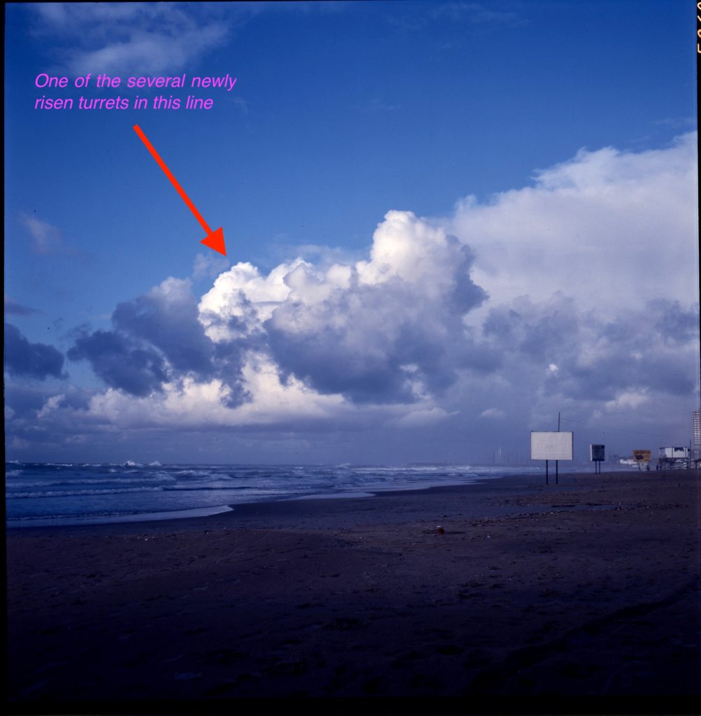
7. The best example of rapid glaciation of shallow cumuliform clouds that I saw in Israel
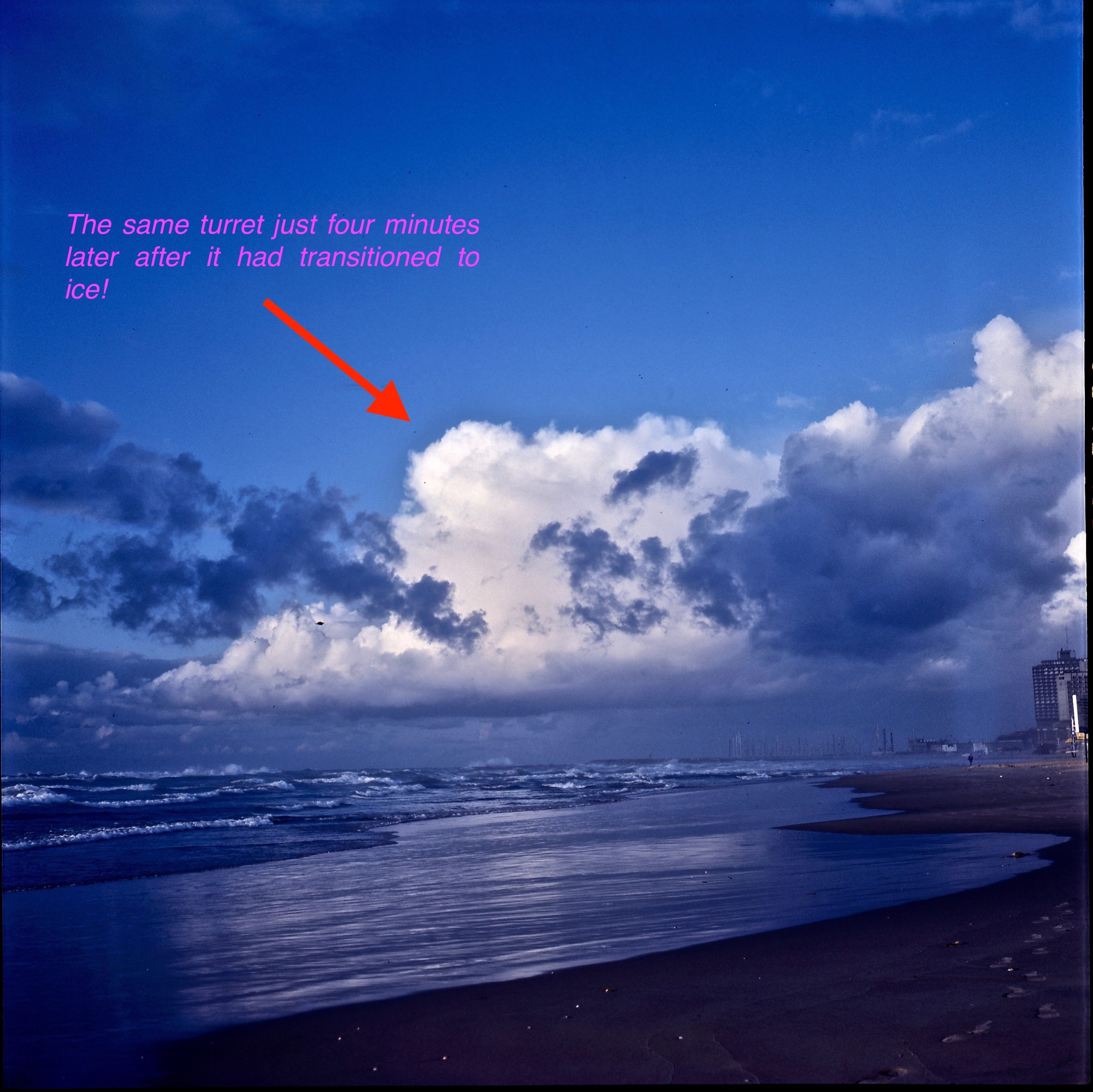
Shallow Cumulus congestus transitioning to modest Cumulonimbus clouds rolled in across the coast north of Tel Aviv on January 15, 1986. This day’s scene was especially good because of the lack, mostly, of intervening clouds toward a small line of Cumulus and Cumulonimbus clouds. The first shot was taken at 1556 LST and the second shot just four minutes later, 1600 LST. The rising turret peaking between clouds in the first shot had transitioned to ice in that time, taking its possible load of momentary supercooled water with it! This kind of speed occurred repeatedly on this day, and other days when I was there.
Recall that lead of the Israeli cloud seeding program, Prof. AG had asserted in his papers that ice particle concentrations in Israeli clouds did not increase with time. (!) Author’s comment: Not possible.
I estimated the tops of the clouds at 4 km ASL and the temperature at -14°C +3°C based on rawinsonde data. Cloud bases were a relatively warm 10-11°C. This estimate was later verified by radar by Rosenfeld (1997, J. Appl. Meteor.); our full discussion of these photos, including the error in time by Rosenfeld (1997), is found here along with replies to his other comments:
Copies of these slides, with the times above annotated on them, were sent in 1986 to Dr. Stan Mossop, CSIRO, Australia, Prof. Roscoe R. Braham, Jr., North Carolina State University, and Prof. Gabor Vali, University of Wyoming.

8. Why was my 1986 Israel cloud study submitted to a foreign journal, the British Quarterly Journal of the Royal Meteorological Society?
Ans.: Neither Professor Peter Hobbs nor myself believed that my 1987 manuscript could be published in journals under the auspices of the American Meteorological Society (AMS). So, we went “foreign.”
I believe that this also relates to the problem I have today with the current “Rise and Fall” manuscript submitted to the BAMS under its current leadership. Perhaps the BAMS editors and its leadership feel they are “protecting” Israel, its science, and the HUJ by rejecting a manuscript about faulty Israeli science with elements of misconduct?
My rejected manuscript in 1983 had already suggested that the AMS audience and its reviewers were not ready to hear what I was going to report, and once again I was going to report that the clouds were markedly different than was being described by the HUJ seeding researchers.
The problem with submitting to the AMS, again? Too many American scientists had heard repeatedly in conference presentations or read in peer-reviewed journals about Israeli clouds plump with seeding potential and low in ice content to low cloud top temperatures (to -21°C) as they were being described by the lead experimenter.
In 1983, and again in the 1987 submitted manuscript, I was reporting that the clouds of Israel had little seeding potential due to how readily they rained naturally when cloud top temperatures were barely cold enough for the seeding agent to even work.
So in 1987 we believed that what I was reporting would not fly in an American journal. The major problem again for AMS journal reviewers would be, as it was in 1983:
How could the HUJ experimenters not know this?
Overseas reviewers, however, such as a Sir B. J. Mason, et al (I don’t know who the reviewers actually were) were likely to be more circumspect, and not at all surprised by mischaracterizations of clouds by members of the cloud seeding community. And they were more circumspect. (As they likely would be with my present manuscript.)
My 1987 submitted manuscript was accepted and published in the January 1988 issue of the Quarterly Journal. My conclusions about the general nature of Israeli clouds have been confirmed on several occasions beginning in the early 1990s in airborne measurements by Tel Aviv scientists and later by others. I had indicated to Prof. AG and several other scientists to whom I wrote to from Israel, that from ground observations the clouds of Israel were producing “50-200 ice particles per liter at cloud top temperatures >-12°C” and that “ice was onsetting in Israeli clouds at top temperatures between -5°C and -8°C.” Of course, these were fantastic statements at the time for those scientists that I wrote to, but they were verified by Tel Aviv scientists whose paper with cloud tops and ice concentrations appeared in 1996 (J. Appl. Meteor., Table 4).
The HUJ researchers, however, could only discern this general characteristic of Israeli clouds in 2015; that precipitation onsets only a little above the freezing level. The Israeli experiments’ Chief Meteorologist, Mr. Karl Rosner, already knew this in 1986 (see his letter), as did the Israel Meteorological Service forecasters I spoke with in 1986. What’s wrong with this picture?
Moreover, as happens in conflicted science environments, the HUJ authors of the 2015 paper could not bring themselves to cite my 1988 paper that had reported 27 years earlier what they were finally discovering about their own clouds in 2015. What does this kind of citing tell you about the science emanating from this group at the HUJ? A lot.
The cause of such high precipitation efficiency, the 2015 HUJ authors asserted, was “sea spray cleansing” of clouds coming across the Mediterranean Sea from Europe. This made them ready to produce precipitation at modest depths with only slightly supercooled cloud tops. The Mediterranean Sea is approximately five million years old.
It was, however, in 1992 that the HUJ seeding researchers first discovered that shallow clouds with slightly supercooled tops do rain in Israel; but only in the specific situation when they were impacted by “dust-haze”, and then mostly on the southern margins of showery days, they reported.
So, why did it take HUJ researchers so long to learn this about their “sea spray cleansed” clouds with all the tools at their disposal? Only the current HUJ seeding leadership can tell us.
9. About the new Israeli randomized cloud seeding experiment and the airborne study that prompted it
Israel, abandoning any idea that the prior cloud seeding experiments had “proved seeding”, again indicative of a terminus, has started over with a new experiment to see, if in fact, cloud seeding works. It’s called, “Israel-4”, now in its seventhseason. No preliminary results have been reported, which is odd. In contrast, the seemingly successful first two Israeli experiments had many interim reports.
Unfortunately, the funder of this new experiment, the Israeli National Water Authority, hired the HUJ “seeding unit” to evaluate seeding potential in the Golan Heights region in preparation for the start of Israel-4, a mistake akin to having the fox guard the hen house.
I reviewed the published article that came out of that HUJ research in 2015 (Atmos. Res.) that described itself as the background airborne cloud study for the new experiment. After reading it, I was not sure it had even been reviewed!
It clearly exaggerated seeding potential in my view; the 2015 authors could not even disclose ice particle concentrations and the rapidity at which they develop in Israeli clouds, critical information for seeding evaluation purposes, claiming that they could not measure ice particle concentrations due to inadequate equipment (manufactured by Droplet Measurement Technologies, Inc.)
I wondered, too, why I wasn’t selected as a reviewer by Atmos. Res. of that 2015 article? My decision on the manuscript would have even been: “accept, pending MAJOR revisions”! This article had some of the best objective writing by the HUJ’s “seeding unit.” But also had a Jeckyl-Hyde aspect where misleading statements kept popping up and along with over-optimized seeding scenarios.
And to the INWA? I would have implored them:
“Don’t do a cloud seeding experiment based on this paper! Get outside researchers to evaluate seeding potential!”
If Israel-4 fails to produce rain via seeding, the faulty HUJ assessment of seeding potential in the Golan will be the cause; the fox will have guarded the hen house as well as expected. And that faulty paper will be consistent with the work of the HUJ seeding group since the early 1970s, work that consistently exaggerated the seeding potential in Israeli clouds and seeding results.