Tired of winter

Winter began, meteorological speaking, yesterday with mid-afternoon temperatures in the upper 50s to low 60s with the wind driving the wind chill down to, I don’t know what, something really low .  In other words,  winter  began here in Catalina about 18 h ago.

Enough already!  Retired to AZ for warm air and low house prices. Pretty bad, too, out there this morning, with the temp at 44° F right now here in Sutherland Heights; colder yet in low spots of course.  Only 36° F now in Black Horse Ranch.

More worse cold expected in about nine-ten days.  Precip somewhat doubtful in that a more better cold slam that hits around the 20th1.   Pretty strong support in the Lorenz plots (aka, “spaghetti plots”), too, for that cold slam, so get ready.  Those crazy plots help us to discern whether a predicted pattern in the model output is an outlier or likely to occur.

In the meantime, going out of chronological order here, THIS coming week end’s lesser cold slam  is DRY in Catalina in USA WRF-GFS model run from last evening’s run.

The Canadian GEM, however, based on the SAME global data as the US model,  has rain a plenty here in Catalina and all of AZ, Sunday and Monday!  The Canadians see a lot of tropical air feeding in from the sub-tropics over much of AZ ahead of the cold front that hits us later Monday, and that’s the reason for all the rain in that model.  The US model doesn’t see the moist sub-tropical stream getting much out of Mexico.

Note the large separation between rain in Cal and rain in AZ in the panel below.

Valid Sunday afternoon, 5 PM AST.  Lower right hand panel has rain amounts that have accrued over the prior 12 h in the model.  As you can see, quite a bit is predicted over SE AZ.  Yay!
Valid Sunday afternoon, 5 PM AST. Lower right hand panel has rain amounts that have accrued over the prior 12 h in the model. As you can see, quite a bit is predicted over SE AZ associated with the system coming out of the sub-tropics ahead of the cold front going across Cal.

So, what’s a weather forecaster to do?

Lean on the Canadians! Their model was ahead of the game on our half-incher rains early in the month compared with the US mod, so they deserve that bit more credibility here, too, I think.

BTW, the two models were identical in not predicting  rain in the  passage of the cold front yesterday.

The End.

PS:  Would post photos of yesterday’s gray, non-precipitating Stratocumulus, lacking ice in it2, of course,  for you to review, but in transitioning to a new OS in the past two days, some things have gotten wrecked, don’t work anymore.   SOS, as they say.

—————————

1Let’s see if any english teachers are reading this blog….

2Cloud lesson/pop quiz  for cloud maven juniors:  What cloud top temperature range would you guess for those non-preciping Stratocu.  Recall it was a cold day, so you know they were at below freezing temperatures…..

Answer:  Guess that tops must have been warmer than -10° C (14° F, in plain speak)!

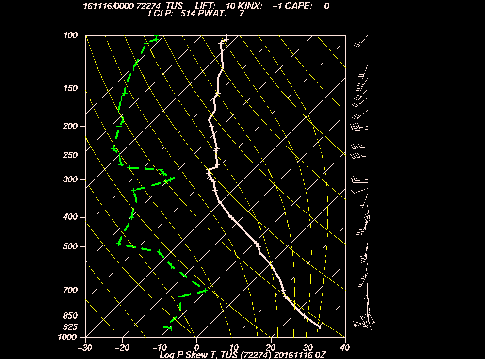
In fact, the TUS afternoon sounding suggests they were about – 5 ° C (or only 23 ° F),  way to warm for natural ice to form, hereabouts, anyway3.

3In really clean conditions, ice does form in clouds with tops as warm as -5° C4.

4These would really be a great factoids to pass along to your neighbors, ones that would enhance your weather esteem in their eyes.  Memorization is recommended.

“Tweener” era begins today after pre-dawn sprinkles; one photo has birds in it

We’ll have to suffer through  a few days for the next storm, i. e., experience sunny weather with pleasant temperatures.  Its amazing that people all over America come to Tucson to experience sunny days with pleasant temperatures!

0.45 inches total in The Heights of Catalina in this latest round of rain, sounds of rain.    Actually, there was also some tiny graupel/soft hail in the rain yesterday, too.

Graupel indicates a lot of cloud droplet water overhead, and that ice crystals were colliding with them until they lost their identity and became little snowballs.  In regions where there are very few ice crystals,  graupel and the harder version,  hail often form.   Its likely that nearly all those rain drops that came down with the little baby graupel were melted graupels.

Graupels…..   Makes me think of that rock group, Led Graupelin, didn’t have the impact of Led Zepelin.  But I have LG’s one and only album entitled, “Compare to Led Zepelin.”   Was only $2.99, too!  Where’s my guitar?  I think I will play, “Stairwell to Heaven” now…

When graupel or hail occur,  there’s a pretty good electric charge up there in those Cumulonimbus clouds.  Its best to be indoors when its hailing until you know if a strike might occur (if there hasn’t been one already).  Besides, its not comfortable being out in hail.   And if you were listening to the rain, you heard a few blasts of thunder toward Lemmon around 2 PM that came out of one of the more enthusiastic Cumulonimbus clouds that went by.  Got 0.12 inches total to add to the night before’s rain of 0.33 inches.

Yesterday in clouds; a sojourn in clouds from morning to evening, in that order with no times noted

DSC_1486

DSC_1500

DSC_1503

DSC_1507

DSC_1517

DSC_1521

DSC_1528

DSC_1530

DSC_1539

DSC_1545

DSC_1556
I know how much you like to see pictures of rain, so here’s one. You’re not like the “others” are you those people around you every day?

DSC_1565

DSC_1569Then the piston of atmospheric subsidence slammed down to squash our Cumulus cloud tops to levels and temperatures where ice could not form….

DSC_1576

DSC_1590
Two picures in a row of a NWS-style rain gauge. Probably has never been done before. Has been getting a workout lately.  Everyone should have one.

DSC_1592

The weather ahead

Kind of funny to see the Canadian GEM model internally plagiarize itself.  Compare last night’s panel at 500 millibars (below) with that same level’s panel  foretold for six days from now.

Yep, its the same thing over again in six days, though with less rain IMO:ann yesterday at 5 PM AST

ann 6 days from now
Valid on Tuesday, November 10th at 5 PM AST.  From the Canadians.

In another interesting model development, the best USA model, the WRF-GFS is having an internal CONFLICT of major proportions.  Check these progs out generated by data only six hours apart.  The first one, showing a big trough coming into Cal, was generated by global data taken at 5 PM AST last evening.  The panel below it was generated by the same model based on global data taken just six hours later, at 11 PM AST (so it the most recent WRF output available) and has a big ridge along the California coast.

2015110500_WST_GFS_500_HGT_WINDS_384
Valid at 5 PM AST November 20th.

“Which one will the fountain choose?”, to quote old song lyrics1:

2015110506_WST_GFS_500_HGT_WINDS_384
Valid at 11 PM AST November 20th.  From IPS MeteoStar.

Of course, spaghetti tells us which one is right, mostly.


The End

————————-

1Except that here we present only two “coins” not three.

2015-16 water year, Oct-Sep, off to good start in Catalinaland

2.83 inches of rain fell in October in Sutherland Heights, Catalina, Arizona, a little more than twice normal for here (based on Our Garden’s record dating back to 1977).    Our Garden is located off Columbus and Stallion here in Catalina, some 2 mi and a bit lower than this site.

The greatest Oct rain at Our Garden or here?

The year was 1983, of course, with 5.61 inches, for perspective.  Nearly all of that fell in the first four days!

Will November continue the above normal rainfall here?

Nope1.

The End

————-

1Wanted to be particularly decisive today.  As a matter of fact, women love decisive men,  FYI, to spice up the blog with some life knowledge outside of clouds and weather, besides this being a cheap trick to attract more readers of gender.

———

Huh?  New thought.  Advice columns have millions of readers!  A cloud blog like this one, 2.  Wonder if I could do advice, to help people live better?  Oh, here’s one that’s just come in:

“Dear CMP:  I want to cut my long hair because I LOVE the convenience of having short hair, but my boyfriend won’t let me. What should I do? Gale.

Dear Gale.  Your boyfriend is right.  No woman should have short hair.  Best of luck, CMP.”

Gosh, that was pretty easy…   I think I could do it!

——-

COntinuing WEATHER discussion….

Sure, we got us Big Niño now,   but they don’t have much effect in November unless some  TS2 comes up from Mexico way.   Niñoes effect more of the later winter and spring, as a rule.

1addendumLong period of “troughiness” is still in the works for the first half of November, but the amplitudes of the troughs will not be great enough to give us much in precip.  Remember,  gotta have the jet stream in the middle levels (i.e., at 500 millybars pressure, 18 kft or so) over us or south of us this time of the year  to get precip.   About 95% of our rain in the cool half of the year has to meet that criteria.  Therefore, it  takes high amplitude trough with the jet stream in the middle levels of the atmo curling around us to bring us rain.

Now wind, we’ll have lots of that from time to time as those troughs go by.

2 “TS”–not in the colloquial sense of the expression, but  rather in the tropical sense.  Well, I guess if it was a HUGE TS that came up, the colloquial sense might be OK…

Hurricane “Q” to slam Tucson in a coupla weeks (in model run)

Remember Star Trek: Deep Space Nine and the  “Q” character?  Well, this has nothing to do with that TEEVEE show, though I liked the opening theme song.  Very majestic; truly a gigantic feel to it, as is needed for outer space travel.  Too bad Aaron Copland couldn’t compose something like that.

Well,  as with the character Q in Star Trek, who was imaginary1, not real, I have just learned that there is no “Hurricane Q” after “Patricia” (P).  If you don’t believe me, check this out while also learning how to pronounce words.

I think its WRONG to skip a letter in the alphabet, and skipping a letter in the English alphabet as though it didn’t exist, could be confusing to those learning English, when naming hurricanes.   So I am going to call the next eastern Pac hurricane, “Q”2.   “Q”, after slamming Baja Central,  is forecast to cause an imaginary flood in Tucson (see maps below).   Also,  since “Q” moves really fast, we probably wouldn’t get more than a few inches of rain here.

BTW, these output maps are from the WRF-GFS model run from global measurements taken  5 PM AST last evening.   The WRF-GFS model is deemed the USA’s best, though its not as good as the ones in Europe as we know.

Also, these maps are valid in  about two weeks from now, so the placement of  “Q”  on them is truly imaginary.

Anyway, I thought I would waste your time with this interesting model scenario.  “Q” looks awfully strong, maybe a 3 or higher category hurricane, too.  That will probably verify I think.

Will waste more of your time if more of these kind of maps below show up (maybe 5% chance) since they excite.

Valid in 348 h! (From IPS MeteoStar)
Valid in 360 h!
Valid in 360 h!  Getting more excited and enlarged annotation font.

The End.

————————

1Well not so imaginary that he doesn’t have a Wikipedia page all to himself.

2The authorities will call it “Rick”,  NOT “Q”.


Jumbo package

Through deliberate deception, the title is likely to bring in quite a few football-centric  people, since “jumbo package” is a term used when an offensive team bring in all the “Sumo wrestlers” they have, usually in attempts to score a touchdown from 6 inches outside the goal line.

The “jumbo package”,   however,  is about some weather, essentially at “mid-field” rather than on the goal line (i.e., just ahead):

A large and very strong upper low center is forecast to arrive on  Sunday, October 25th, football day, the last reference to football in this blog.  As it passes over Arizona, the first snow of the year would likely fall on the ‘Frisco Peaks by Flagstaff.

Tremendous rains, too, would  occur here in AZ with this low,   espepcially2 here the SE corner, should it happen.  See WRF-GFS model outputs below, as rendered by IPS MeteoStar:

Valid on Sunday, October 25th at 5 PM AST.
Valid on Sunday, football day, October 25th at 5 PM AST.
Valid on Sunday, football day, October 25th at 5 PM AST.  The bluish regions denote especially heavu rains having fallen in the prior 12 h.

But does it happen?

Let’s check the spaghetti from NOAA for a hint about whether this weather happenstance has much chance of occurring:

Valid on Sunday, October 25th, at 5 PM AST.
Same map as above, except annotated for those who find the map geographically challenging.
Same map as above, except annotated for those who found the first  map geographically challenging.

You, too, as an expert on spaghetti now,  are as crestfallen as I was to see this spag output from last night, showing that the espepcially strong low is, in fact, an outlier;  a not impossible situation, but an unlikely one since we don’t have the bunched blue contours where the jet stream is strong,  down thisaway.  Rather, those blue lines are grouped over the Pac NW, and only one or two bluish contours are down here, ones that would be associated with that upper low on the 500 mb map above for Oct. 25th

Still, even when you know its an outlier, it brings hope for a bountiful rain, which is good.  Will monitor this as the days go by, in case the outlier spaghetti output is an outlier.

The weather just ahead

Of course, as all weatherman know, we still have our boomerang friend Joe Low returning with rain; that’s in the bag, and  has a little “friend” following behind him.  These, combined,  should  bring substantial rains overall in AZ and in the Catalina area,  in the form of scattered showers and TSTMs that persist over several days beginning later Thursday through Monday.  Joe et al. are slowpokes, which is good.

Haze and smoke are up, if you’ve noticed that our skies have been not so blue, but whitish.  Stuff is coming up from Mexico it appears; (Smoky) Joe will bring more of that before it gets here.  So, look for a hazy patches of Altocu and/or Cirrus in the next couple of days.  Maybe a small Cu off in the distance.

2:06 PM, October 11th.  Shows the kind of hazy, smoky conditions we've been having lately.  There is also some delicate Cirrus up there contributing to the whiteness.
2:06 PM, October 11th. Shows the kind of hazy, smoky conditions we’ve been having lately. There is also some delicate Cirrus up there contributing to the whiteness.

The End


——————————-

2“Espepcially” is a word I made up via some inadvertent key strokes, but I kind of like it:   “In particular, but with some energy.”     BTW, Coke tastes better than Pepsi, if that new, unexpected word made you think of a soft drink.

Twofer

Rarely do passing lows get a two chances to produce rain, but the low passing overhead today and tomorrow, does. Ten days from now, its overhead again! How funny izzat? And precipful, too.

Measurable rain will fall today in Catalina CDP (“Census Designated Place”, i.e., its not a city), and in about 10 days when the SAME low returns after a boomerang trip down Texico way, thence to Baja, thence to so Cal, and back over Arizona on the 10th-11th after picking up some juice over the east Pac.

Thinking, as you are now, of a minimum of 0.05 inches and top of 0.50 inches, the latter larger amount if projected afternoon thunderstorms land on us.   Thus, best estimate, average of those two extremes, thinking Gaussian conceptual model modal value here, about 0.275 inches.

BTW, should be something in the way of an arcus cloud, or a batch of low scudding clouds underneath Cumulus and Cumulonimbus bases this afternoon as a windshift to the NW comes through in the afternoon or early evening hours, well in the next 18 h or so.  That could be a dramatic sight, and with that windshift, the temperature will drop 5-10° F.

When the low trudges over us the second time around in mid-October, the estimated extreme amounts are a trace minimum, and 1.00 inch max, in other words, pretty clueless here about how much could fall the second time around ten days from now.

If you don’t believe me about all this, here are is the WRF-GFS prediction for this afternoon, followed by the WRF-GFS model prediction 10 days from now, today being October 6th, in case you don’t know what the date is today, maybe you’re retired and lose track of the days and dates because you don’t have a lot to do everyday, just kind of sit there:

5 PM AST, today, October 6th.  Joe low goes by, heads toward Texas.
5 PM AST, today, October 6th. Joe low goes by, heads toward Texas.
5 AM AST, Friday, October 16th, the day before football day.
5 AM AST, Friday, October 16th, the day before football day.  Joe returns after visiting NM, TX, MEX,  Baja, east Pac, then  SC.  Full cycle here, from IPS MeteoStar.  Pretty humorous to watch this happen.

 Yesterday’s clouds, punctuated by a large worm

6:57 AM.  If you thought the clouds were fatter to the north most of the day yesterday, you were right.  Many modest Cumulus passed overhead of Catalina and then fattened up to the north because the lifting mechanism aloft was stronger to the north of us.  Quite a few  moiuntainstations registered over an inch to the north of us.
6:57 AM. If you thought the clouds were fatter to the north most of the day yesterday, you were right. Many modest Cumulus passed overhead of Catalina and then fattened up to the north because the lifting mechanism aloft was stronger to the north of us. Quite a few moiuntainstations registered over an inch to the north of us.

However for a moment, we did have a shower threat move toward us from the south, this:

11:52 AM.  Whilst on a hike up the Baby Jesus Trail, this appeared.  Looked promising!  But, vaporized into mere sprinkles.  If you saw this, you almost immediately were thinking of ice forms like needles and sheaths, since the cloud was relatively shallow, and its still warm aloft.  Needles and sheath (hollow columns) only form at temperatures above -10° C.  Such an occurrence is rare in Arizona, so, quite an interesting bit of hand-waving here.
11:52 AM. Whilst on a hike up the Baby Jesus Trail, this appeared. Looked promising! But, vaporized into mere sprinkles. If you saw this, you almost immediately were thinking of ice forms like needles and sheaths, since the cloud was relatively shallow, and its still warm aloft. Needles and sheath (hollow columns) only form at temperatures above -10° C. Such an occurrence is rare in Arizona, so, quite an interesting bit of hand-waving here.
10:57 AM.  Hike up the Baby Jesus Trail was punctuated by seeing a very colorful worm of some kind.  Not much else happened in weather or wildlife the rest of the way,  Morning glory coverage was a little disappointing.
10:57 AM. Hike up the Baby Jesus Trail was punctuated by seeing a very colorful worm of some kind. Not much else happened in weather or wildlife the rest of the way,  Morning glory coverage was a little disappointing.
4:17 PM.  I am sure when you saw this Cumulus congestus that you, as I was, thinking you'd see a little ice emit out the right, aging and descending side.  No ice was visible.  However, it was kind of neat to think how close we are now in our cloud assessments, right or wrong.
4:17 PM. I am sure when you saw this Cumulus congestus that you, as I was, thinking you’d see a little ice emit out the right, aging and descending side of this cloud.  In fact, no ice was visible. However, it was kind of neat to think how close we are now days in our cloud assessments, right or wrong.

The End

Filling up the portent jar…

With these model outputs1 for early October.  First, a tropical system barges into Arizona bringing copious rains:

Valid in 264 h, only 11 days from now!
Valid in only 10 days from now, sometime in October.  Forget any rain chances in the rest of September.  Temperature plummeting here now after hot night of foehn like wind from the north.

2015092500_WST_GFS_500_HGT_WINDS_252

The exact same map above with annotation.
The exact same map shown above with annotation for helpless little weather babies that can’t see what’s going on.

But its gets even BETTER!  In only two weeks, this tropical rampage:

A near hurricane strength tropical storm is about to smash into  southern California bringing widespread rains to Cal and the whole SW, which once again, includes Arizony.
A near hurricane strength tropical storm is about to smash into
southern California/northern Baja bringing widespread rains to Cal and the whole SW, which once again, includes Arizony.  Wow, wouldn’t that be something!

2015092500_WST_GFS_500_HGT_WINDS_384

The End

———————————-

1These outputs, rendered by IPS MeteoStar, a great weather provider, are from the WRF-GFS model.  You can’t find a better model than the WRF-GFS, unless you can access the European one (ECMWF), thought to have better “skill scores”.

So, combined with the giant El Niño in progress, which will spin off stronger tropical storms than usual (definitely), and the results of trillions of calculations from our best model that shows a lot of rain headed this way in TWO episodes in 10-15 days.   The  chances of this actually happening are way over 10%!

Spaghetti actually has a “weakness” in the upper level pattern that will allow that first system to creep toward us; not so much support for Hurricane “Giganta” that comes toward SC, or system number two.

Will get back to you when the drops start falling…

Dust up

Cloud maven persons certainly saw this from the beginning;  that scruff of something dark coming over the hills from the  Avra Valley late yesterday afternoon.  Here it is:

4:37 PM.  Dark cloud cloud, smoke or dust, creeps over the hills SW of Marana from Avra Valley.  Didn't know what it was myself, which is quite something in itself.
4:37 PM. Dark cloud cloud, smoke or dust, creeps over the hills SW of Marana.  Didn’t know what it was myself, which is quite something in itself.
4:48 PM  Dark something creeping into Oro Valley.
4:48 PM Dark something now invading Oro Valley.  Hills now obscured.  Was thinking it was a grass fire since there had been no thunderstorm in the area upstream  that might have produced outflow winds.
5:22 PM.  By this time is was apparent that this was a dust storm that had raced over the hills and into Oro Valley, on its way to Catalina, a very thin version of a 'Boob.  Pretty amazing since there seemed to have been no storm to have produced it.
5:22 PM. By this time is was apparent that this was a dust storm that had raced over the hills and into Oro Valley, on its way to Catalina, a very thin version of a ‘boob. Pretty amazing since there seemed to have been no storm to have produced it.

The rest of the story, as Paul Harvey used to say, was that the wind suddenly gushed in Catalina, estimated to 40 mph, briefly with a bit of haze due to this dust.  A few drops of rain fell here from that layer cloud above that dust cloud a little later.

Nice little momentary and surprising splat of rain here last evening just after dark (about 7:30 PM).  Radar showed just a little dot of rain when it happened.  Drops were heavy enough for us to say, “What’s that?”, thinking it might be wind.  Hardly lasted a minute.

Big LA rain yesterday morning!

A very surprising, heavy rain was in progress yesterday morning in southern Cal, Ventura County line southward into Baja,  from the remains of tropical storm, Linda.    Downtown LA got over 2 inches, as did numerous other sites.  That would be about ten times the average September rainfall.

We seem to continue in the humid stream from Linda.  Temp now 71 F, dewpoint 65!  Very Hawaiian with Strato cu again topping Samaniego (Sam) Ridge.  Likely to be a day similar to yesterday, kind of flat clouds on top of moderate Cumulus, with some tops protruding high enough to form ice.

Microphysics module

What kind of ice?

Probably needles and sheaths (aka, hollow columns), as likely was the type of ice in those clouds that barely precipitated, i. e., had the warmest tops, and produced fine veils of rain.

The heavier shafts suggested taller tops, colder than -10 C  (14 F) with more complex ice crystals like stellars and dendrites form.    All guesswork here, but hey, guessing is fun.  The afternoon TUS sounding, which I just now looked at AFTER guessing, SEEMS to support these guesses.

In sum, yesterday was likely an unusual day for Arizona with ice forming in clouds with tops equal to or warmer than -10 C.  This can really only happen when the clouds are especially loaded with water and are rather “clean” having lower droplet concentrations, both of which allow the formation of larger sizes of droplets in the clouds, which in turn, if you are still with me, leads to ice forming at higher temperatures than normal.  The usual ice-forming temperature in AZ clouds is lower than -10 C since droplets are rarely very large in clouds here until they’re colder than -10 C.   Well, that takes care of the last reader…..he’ll  never be back.

The weather WAY ahead

The models continue to predict a longish spell of rain during the last ten days of September.   In fact, the 18 Z WRF-GFS model run from yesterday had more rain in AZ than I have ever seen in a model output during that spell.  Of course, as realistically weathermappy as these model outputs look, they are not too reliable, though this spell continues to be predicted in run and after run, as it has even with the latest (06 Z, 11 PM AST last night’s) run here.

From yesterday’s 18 z run, to fuel your imagination and hope, take a look at this output before they are overwritten by  MeteoStar later today when the new 18 Z run is posted.

The End.

Blues returning to Tucson!

You won’t have to go to New Mexico, Sonora, or the Indian State of Kerala to find great summer rain.  According to this model output from last evening, its only a bit more than a week away!

The last time we saw a model prediction like the ones below, was for the 24 h ending today, made a whopping 12 days ago.  When you consider the great rains we had ending YESTERDAY morning (2-7 inches in the mountains, and inch here in The Heights, that far out prediction was only a day or so off.  So,  there’s hope that the paucity of summer rain that has left our desert so brown will be rectified a bit more in the near future.

Below, from 5 PM AST obs, the WRF-GFS 12-h rain totals predicted for August 20 and beyond as rendered by IPS MeteoStar.   Normally, these are pretty useless predictions, but since that last one with so much rain foretold was close to what actually happened, maybe there’s something to watch out for around the 20th.

Ann 2015080900_CON_GFS_SFC_SLP_THK_PRECIP_WINDS_276
Valid at 5 AM AST, August 20th. Colored regions denote areas where the model has calculated that rain has fallen during the prior 12 h. Blue indicates heavier precip than green.
2015080900_CON_GFS_SFC_SLP_THK_PRECIP_WINDS_300
Hard to be bluer than this! Valid in only 288 h from now!  Valid on Friday, August 21st at 5 AM AST.

Some recent cloud photos

12:46 PM, August 7th.  Telephone pole is going down on Linda Vista due to a microburst.
12:46 PM, August 7th. Telephone pole was going down on Linda Vista due to this microburst outflow.
2:45 PM, August 7th.  The Gap gets shafted.  Nice.
2:45 PM, August 7th. The Gap gets shafted. Nice.
2:55 PM, August 7th.  One of the great cloud bases of our time begins to take shape UPWIND of Catalina!
2:55 PM, August 7th. One of the great cloud bases of our time begins to take shape UPWIND of Catalina!
3:03 PM, August 7th.  "So round, so firm, so fully packed", as the cigarette ad used to say.  This is looking really great for Catalina at this point.  I am sure I am reflecting the excitement you felt that day.
3:03 PM, August 7th. “So round, so firm, so fully packed”, as the cigarette ad used to claim. This is looking really great for Catalina at this point, might unload right on us!. I am sure I am reflecting the excitement you felt that day.
3:03 PM, August 7th.  "Droop, there it is", as they used to sing on In Living Color.  Who woulda dreamed that Sasha Alexander would be one of the Fly GIrls on that show?
3:03 PM, August 7th. “Droop, there it is.  A report from Birdman, Rick Bowers, indicated that 1.16 inches fell in just in this storm. over there on Trotter, south end of Catalina.   Only 0.71 inches in the Sutherland Heights, but still great.  Fizzlerama continued as the storm headed north toward Saddlebrook with less than 0.2 inches there.
3:20 PM, August 7th.  Visibility, for a few seconds, down to 1/8th of a mile in TRW++, wind gusts to 30 kts or so.  Now this is exciting!  Temp dropped from 97 F to 72 F!
3:20 PM, August 7th. Visibility, for a few seconds, down to 1/8th of a mile in TRW++, wind gusts to 30 kts or so. Now this is exciting! Temp dropped from 97 F to 72 F!  This was not quite the lowest visibility.
After a night of intermittent rain and thunder, dawn yesterday brought this dump on Sam Ridge, where 1.06 inches fell in an hour, 0.51 inches in 15 minutes.


The End.


Some cloud scenes from yesterday; a forecast map gone awry?

0.07 inches here in Sutherland Heights yesterday afternoon. Much more SW-NW of us, as the photos below show.

DSC_7961 DSC_7955 DSC_7945 DSC_7924 DSC_7909

A predicted super hurricane?

I now direct your attention to the forecast maps below, produced by the WRF-GFS model last evening’s global data, courtesy of IPS MeteoStar, the usual.  The aforementioned extremely strong hurricane foretold in the models 24 hours ago, has acheived in this latest run, mythical strength, possibly a Category 6 or 7 (which don’t yet exist).

We presume the model went berserk, so its kind of fun to imagine how intense, how low the pressure in the center of such a goofy predicted hurricane could possibly be in the panels below.

First, the jaw-dropping -to-weather-nerds like the current writer, predicted height of 540 decameters height of the 500 millibar pressure level!  For the pressure of 500 millibars in the atmosphere to be reached at a level that LOW in warm tropical air means that the sea level pressure must be astoundingly LOW to begin with.  In warm air, the pressure doesn’t change as rapidly going up as it does in dense cold air.

I don’t believe, in viewing many weather maps with hurricanes that a height that low has ever occurred at 500 millibars.  Thus, the pressure at sea level, for whatever reason, must be incredible in this predicted hurricane SW of Cabo.  Surf will be up!

The record measured low pressure at sea level is 870 mb in one of the super typhoons (Typhoon Tip) in the Pacific some years ago where winds were estimated at about 200 mph.  It is thought that recent devastating Super Typhoon Haiyan, 2013, had a lower pressure, 858 mb, or the equivalent of the density of air at 5,000 feet elevation was thought to have occurred at sea level!

Valid at 5 AM AST, Sunday, July 19th.
The heights of the 500 millibar pressure level predicted for 5 AM AST, Sunday, July 19th.  The center of the hurricane SW of Baja  is shown to be 5400 meters (540 “decameters”).
2015071000_WST_GFS_SFC_SLP_THK_PRECIP_WINDS_228
Valid at the time of the above map. The surface pressure lines are too packed to display, but the center pressure would certainly be less than 900 millibars, and in such a tight center, winds, maybe 200-300 mph, tornado-like. Kidding only slightly.

OK, enough fun with a crazy model prediction, though this hurricane will be extremely strong, and the models are still bringing its pathetic, but wet, remnant into California a couple of days later.  Many July rain records, though they are not much to begin with, will be broken if this remnant does make it to Cal.

What we really hope for is some aircraft reconnaissance reports during the life of this strong hurricane instead of satellite-derived estimates of strength (though the latter are quite good).

We still look quite wet during this period, too.


The End.