Arthur L. Rangno[1]
Catalina, Arizona 85739
[1]Retiree, Research Scientist IV, Cloud and Aerosol Research Group, University of Washington, Seattle (1976-2006). Co-winner in 2005 with the late Prof. Peter V. Hobbs of a monetary prize adjudicated by the World Meteorological Organization concerning our work in cloud seeding/weather modification.
Target journal: Research Integrity and Peer Review (?)
ABSTRACT
This study surveys the citing practices in the literature of cloud seeding experiments. In particular, 90 peer-reviewed journal articles that cite experiments in Colorado and Israel are of particular interest because both went through almost identical rise and fall cycles. Both sets of these experiments were once deemed by our highest scientific organizations and many individual scientists as ones that had proved “cloud seeding works” (e.g., National Research Council-National Academy of Sciences 1973 for the Colorado orographic experiments; Kerr (1982, Dennis 1989) and in numerous places for the first two experiments in Israel.
But what happens in the journal peer-reviewed literature when such esteemed sets of experiments are shown to be ersatz “successes,” as happened later to each set of these experiments? It will be shown in this review of those 90 peer-reviewed publications in several journals that there is an appreciable fraction of researchers who continue to cite only the successful phases of these experiments, thus demonstrating, “one-sided” citing that misled their readers. These instances, first and foremost, represent failures in the peer-review process.
It is recommended that explicit wording that condemns one-sided citing be placed in our AMS professional “guidelines[1]” The Weather Modification Association, too, should add a similar explicit wording that condemns one-sided citing in its still extant, “Code of Ethics.” (The AMS eliminated its “Code of Ethics” many years ago in favor of less stringent, “Guidelines.”)
- Introduction.
The purpose of citing in journal articles is to give the reader an accurate, balanced, and up to date background on the area of science being discussed, and to support various assertions in articles so that the reader can see that what is being stated has been shown to have support or needs further research. Our science ideals mandate that we do this as best we can. Selective or “one-sided citing” is defined as when an author or authors cite only one side of an issue that is multifaceted; only part of the “story” is revealed to the journal reader, the side that the authors, and by inference, the reviewers of such manuscripts, only wish them to know about.
However, in controversial domains where strong differences of opinion, vested (funding) interests and a priori beliefs (confirmation and desirability bias) abound, we may fall short of this ideal. But by how much, if any?
We answer this question by examining citations in articles that concern two sets of once highly regarded cloud seeding experiments, those conducted by Colorado State University scientists at Climax and Wolf Creek Pass, Colorado, and those conducted in Israel by scientists at the Hebrew University of Jerusalem. This test of evenhandedness in our science literature comes by examining the citations in the peer-reviewed literature one-year or more (final accepted date is used) after significant flaws were reported for these experiments to see if the reports that compromised them were also cited, presumably for the purpose of alerting the reader to the discovery of problems.
We used the “advanced search” option of the American Meteorological Society (AMS) journal web site using author names to find the articles that have been associated with these experiments. The author names used were those associated with the original reports of cloud seeding successes.
Citations in the 1986 AMS Monograph, 43, No. 21, “Precipitation Enhancement—A Scientific Challenge” were also inspected and were included if they met the search criteria.
Peer-reviewed articles in the J. Wea. Mod., published annually by the Weather Modification Association (WMA) were also examined. The non-peer reviewed articles within that journal were ignored.
The Isr. J. of Earth Sci.was also examined from 1980 through 2011 when the journal discontinued publishing. Two articles were found that met the citing criteria.
Search year initializations for the experiments: For the Climax and Wolf Creek Pass experiments in Colorado, compromising literature began to appear with Meltesen et al. (1978), Rangno (1979a, b) Hobbs and Rangno (1979a, b), and Mielke (1979). Therefore, our scrutiny of citing practices in peer-reviewed cloud seeding articles for these experiments begins in 1980.
For the Israeli experiments, the first flaw casting doubt on seeding efficacy was reported in January 1988 (Rangno) concerning the clouds of Israel, and was followed by Gabriel and Rosenfeld (1990) who reported a null statistical result for the “full” Israel-2 crossover experiment. The a priori designed crossover result of this experiment (Silverman 2001), completed in 1975, had not been previously reported. The scrutiny of the citations regarding these two experiments, Israel-1 and 2, therefore begins in 1989.
In essence, the null hypothesis of this survey based on the ideals of science is that there will be no differences in citation practices following the appearance of the compromising literature; i. e., both the flaws in these sets of experiments and the successful phases will be reported in the articles that cite them after the starting dates above to give the reader a full view of what happened to them.
If only the “success” phase of the Colorado and/or Israeli experiments have been cited in a journal article after the dates that compromising literature appeared, that publication is deemed as having exhibited, “selective” or “one-sided” citing (Schultz 2009).
Conference preprints or “grey” literature, such as “Final Reports,” are included in this study if they provided key information that was not published elsewhere, such as ice particle concentrations vs. cloud top temperature (e.g., Grant 1968, Vardiman and Hartzell 1976, Grant et al. 1982). These types of literature appear in a blue font with a gray background in the references. They often revealed problems in these experiments that did not reach the peer-reviewed literature. Many “grey literature” reports that were cited in journal publications were not available for this purpose.
This survey, in effect, also answers the question, “How exactly does the scientific community react to those who tear down established scientific consensuses rather than building them up?” “Are they welcomed or shunned?” despite our ideals that mandate us to tell the ‘full story’ to journal readers.
2. Defining contrary or compromising literature
In one type of literature that can be regarded as “contrary” or “adverse” to a cloud seeding success are cloud reports that go counter to the reports of the experimenters who often reported lower ice particle concentrations in the natural clouds. That is, they described clouds that were ripe for seeding that explained a result where seeding had appeared to increase precipitation. When literature appears that contradicts the “ripe for seeding” cloud reports, that in fact, the clouds that were targeted had much higher natural ice particle concentrations, these later findings are considered “adverse” or “contrary” literature. Findings like the latter cast doubt that a claimed statistically significant success due to seeding actually happened. Assertions by the experimenters that cloud top temperatures indexed ice particle concentrations are also assayed and if found unreliable in later research, the later findings are also considered “adverse” to the original reports.
Both the Colorado and Israeli experiments suffered from these kinds of “adverse” published cloud seeding literature where the true nature of the clouds in each locale does not support the idea that significant increases in precipitation could have been produced by cloud seeding.
The most obvious “contrary” literature is that where a reanalysis of the original experiments has taken place that demonstrates that a natural distribution of storms (“storm types”) on seeded days created the misperception of seeding effects or a Type I statistical error (e. g., Neyman 1977). For maximum credibility, however, re-analyses should not be wide searches through many variables (i.e, “fishing expeditions”) but far simpler; those, for example, that only expand the original reports to regional views using the same data and experimental dates as did the experimenters. This type of analysis is one that should have been conducted by the original experimenters in the first place, but is often overlooked as they focused on small target areas, as in the Climax and Wolf Creek Pass experiments in Colorado (e.g., Mielke et al. 1970, Morel-Seytoux and Saheli 1973).
- Results.
Ninety peer-reviewed cloud seeding articles referenced the two benchmark sets of experiments after the dates that compromising literature began to appear in journals or in “grey” literature. Of the 90 peer-reviewed articles examined, 38, or 42% did not cite literature that compromised the successful phase of the experiments in Colorado or Israel; they only cited the successful phase for the reader. These 38 articles are deemed to have exhibited “one-sided” or “selective” citing.
Twenty-six of 76 articles, or 34%, that exhibited one-sided citing were in American Meteorological Society publications. Twelve of 13 articles in the peer-reviewed segment of the J. Wea. Mod. exhibited “one-sided” citing, or 92%, of those articles that cited the Israeli or Colorado experiments only cited the successful phase.
The three peer-reviewed articles not under the AMS “tent” or in the JWMA, one in Atmos. Res., and two in the journal, Israel J. Earth Sci., did not exhibit one-sided citing but gave the reader a second view.
The NRC-NAS 2003 volume, “Critical Issues in Weather Modification,” was also reviewed for citing balance, and was found to be skewed toward leaving out important references to publications that compromised those experiments that they had deemed successful in their prior review in 1973. The NRC-NAS 2003 review does not compare in depth to that of the 1973 review. A total of 18 relevant cloud seeding reports or peer-reviewed publications went uncited in this volume (see Appendix 3 for the extant adverse literature that went uncited in the NRC-NAS volume: Fur67, AVM69, VGr72a, b, V74, VH76, V78, R79, HR79, Rh83, R86, RoG89, L92, L94, LGG96, LKR97, RH97a, b, ROS98. Abbreviations are explained in Table 3.
For those few wishing to go farther, a comprehensive review of the NRC-NAS 2003 document by the present writer can be found here.
The articles examined for citing tendencies are listed in Tables 1-3 below the reference section. Table 1 is for AMS publications, including the AMS monograph on cloud seeding, and other journals, including a list of citations within NRC-NAS, “Critical Issues in Weather Modification Research.” Table 2 is for those articles in the J. Wea. Mod. A key to the many abbreviations of relevant literature cited in each article that met the search criteria is found in Table 3.
The table linked to below is a list of those authors that led or participated in one-sided citing and their institutions. In cases where the author name appears once, it was probably a “peccadillo” due to careless citing or possibly ignorance of the full literature on the experiments in Colorado and Israel. Where an author’s name appears repeatedly, it can be surmised that there was an agenda that meant included not informing readers of the full story, thus misleading them.
https://cloud-maven.com/wp-content/uploads/2022/01/One-sided-authors.pdf
- Two examples of omitted literature.
Breed et al. (2014) in the context of the National Center for Atmospheric Research’s (NCAR) involvement in cloud seeding in Wyoming, mention the Climax randomized experiments by only citing a single publication, Mielke et al. (1981). In Mielke et al. (1981), the journal reader will find the story of a robust cloud seeding success. Breed et al. (2014) deflected the reader from the voluminous contrary journal trail that preceded and followed Mielke et al. (1981), a trail that began with Meltesen et al. (1978), Hobbs and Rangno (1979), Mielke 1979, Rhea (1983) and several more re-analyses and commentaries (Rangno and Hobbs 1987; 1993; 1995, Rangno (2000).
Hobbs and Rangno (1979a, b) found that the underlying physical foundations for a seeding success at Climax, the stratifications of experimental days by 500 mb temperatures, claimed to have had cloud microstructure implications, was unreliable, as did several other researchers, including Mielke (1979), Cooper and Saunders (1980).
This contrary literature goes uncited by Breed et al. (2014). Why? Was it because the authors wished their journal readers to view only one side of the Climax literature to convince readers that a cloud seeding success had been attained in the Rockies? This as the State of Wyoming inexplicably considers cloud seeding after the sophisticated Wyoming randomized orographic cloud seeding experiment, designed and evaluated by the National Center for Atmospheric Research, “failed to deliver” (they got a null result after six seasons of winter seeding).
In fact, the Climax experiments have no remaining credibility as having produced reliable evidence of increases in snowfall due to seeding, as a read of the abundant contrary literature listed above will show. Thus, the single citation to Mielke et al (1981) by Breed et al. was tantamount to solely citing Fleishmann and Pons (1989) as evidence of “cold fusion.”
Another example of omitted contrary literature was seen in in Freud et al. (2015—hereafter, F15) study of Israeli clouds. F15 discovered the high precipitating efficiency of Israeli clouds 27 years after Rangno (1988) and Levin (1992, 1994) deduced the same ready formation of precipitation in Israeli clouds. But F15 does not cite that 1988 breakthrough paper.
F15 also cite Givati and Rosenfeld (2005) who asserted that Israeli operational seeding-induced increases in rain were completely masked by air pollution. But F15 did not cite those articles by Kessler et al. (2006), Alpert et al 2008; Halfon et al. 2009; Levin (2009); Ayers and Levin (2009), all of whom reviewed the Givati and Rosenfeld claims and found them unconvincing.
The final arbiter for this dispute was the Israeli National Water Authority that also found the pollution claims of Givati and Rosenfeld unconvincing after weighing all the evidence. Operational seeding of the Lake Kinneret (Sea of Galilee) watershed was therefore terminated in 2007 (Sharon et al. 2008). There is some question whether the programs was terminated then or in 2013. Nevertheless, it was terminated.
Instead of operationally seeding all storms, instead the Israeli government undertook a new randomized cloud seeding experiment in the hilly north of Israel. The results of this new experiment, called Israel-4, has just been published by Benjamini et al. 2023. The result of randomized seeding was a null result on rainfall. Benjamini et al. 2023 also performed “one-sided” citing by only citing the success phase of the first two Israeli experiments and did not cite the considerable contrary literature that followed the success phase. These authors should have cited Rangno (1988), and Rangno and Hobbs (1995), the latter a reanalysis of those experiments that showed convincingly that they were the product of favorable draws on randomly chosen seeded days. This would have given the readers a “heads up” that Israel-1 and Israel-2 were NOT straight forward successes as Benjamini et al. (2023) claim in multiple places.
Moreover, Levin et al. (2010), which was cited, corroborated Rangno and Hobbs (1995) concluding that Israel-2 was compromised due to natural storms that favored the misperception of a cloud seeding effect. Both publications, that by Rangno and Hobbs (1995) and that by Levin et al. (2010) were subject to considerable comments mostly by those who carried out the experiments.
5. Discussion.
One-sided, or selective citing in our journal literature has been demonstrated as a frequently occurring phenomenon in the cloud seeding literature. From a standpoint of our ideals of science, it should never occur. Readers should never be misled. One-sided citing can be seen as having been encompassed by the Federal Trade Commission’s statement on consumer fraud, adjusted below for the science reader:
“Certain elements undergird all deception cases. First, there must be a representation, omissionor practice that is likely to mislead the consumer [journal reader].”
To mislead, to truncate truth, as one-sided citing is, by any reasonable definition, a form of “scientific misconduct.” It is, alternately, to use the phrasing of the NRC-NAS (e.g., 1995, 2009), “cooking and trimming” the truth. One-sided citing, to this author, is the same as eliminating a data point.
The issue of one-sided citing has been called out by Schultz (2009): “One-sided reviews of the literature that ignore alternative points of view, however, can be easily recognized by the audience, leading to discrediting of your work as being biased and offending neglected authors…”
Not surprisingly, selective citing has been noted in other science domains (Urlings et al. 2019).
The damage caused by one-sided citing is not just to authors who are seen as biased, it also causes material damage to authors whose work goes inappropriately uncited; they may lose ground in promotions, awards, and without doubt, in the perceived impact that his/her work has had on his/her field since impact is measured by citation metrics. From the Council of Science Editors:
“Most metrics of scholarly performance, including the Journal Impact Factor (JIF), are based on citations to published articles.”
The less you are cited, the less impact you are perceived to have had in your field.
The question for us then becomes, “Is it OK to have even just a single one-sided reference to one side of the ‘coin’ in our journal articles?”
We think not.
It was also clear that even though there was an abundance of contrary literature, the successful phase citations to cloud seeding experiments far outweighed the citations to contrary literature. It was also observed that some (unnamed) authors never refer to compromising literature suggesting personal agendas.
5. The institutional and co-author ramifications of one-sided citing
It can be argued that authors who practice one-sided citing damage their own institutions. Authors who have performed “one-sided citing” have been associated with such highly regarded institutions such as the National Center for Atmospheric Research, and the Hebrew University of Jerusalem. Those authors have shown little regard for the implicit damage done to their home institutions by “easily recognized” one-sided citing. Moreover, responsibility for such acts is shared among of all the co-authors who are co-authors of publications that contain this act.
- What one-sided citing says about peer-review.
One-sided citing is also an “LED signpost” of inadequate peer-review of manuscripts. Reviews by knowledgeable, objectivereviewers would never allow one-sided citing to take place in manuscripts destined for publication. This could only happen if journal editors assigned reviews to those ignorant of the full body of literature that a manuscript addresses, or to seeding partisans that allow one-sided citing to reach journals. The J. Wea. Mod. results are particularly suggestive of editor/reviewer bias.
Inadequate or partisan reviews have cost the public and our science cloud community much pain over the entire history of weather modification as long-time observers know. The nation’s most costly randomized orographic experiment, the Colorado River Basin Pilot Project, 1970-75, was based on prior, published cloud seeding “successes” that never happened in the first place. But those ersatz reports of successes got into our peer-reviewed literature anyway and convinced our best scientists that they were successes due to weak reviews of manuscripts.
The sad aspect of these one-sided journal articles is that a single sentence or even a footnote following the report of the original “success” stating, “These results have been questioned or overturned”, followed by a reference or two, would have made this survey unnecessary. The recent review of orographic cloud seeding by Rauber et al. (2019) fulfills this simple requirement.
- What to do about one-sided citing?
Explicit wording that condemns one-sided citing is required in our AMS professional “guidelines[1]” The Weather Modification Association, too, should add a similar explicit wording that condemns one-sided citing in its still extant, “Code of Ethics.”
Integrating the language of the FTC quoted above at the beginning of this essay (with the applicable word changes) into our AMS “Code of Ethics” would be the responsible course to follow to stop what could be seen as fraudulent acts (no matter how minor they might seem) that mislead readers to false conclusions and harms uncited researchers. Moreover, such acts denigrate the institutions from which “one-sided citing” emanates.
[1]Also, restore the original AMS label for our professional responsibilities, our stronger label, “Code of Ethics” from the current, mere, “Guidelines” label.
- Conclusions.
We have shown that there is a credibility “inertia” that is not easily reversed; that the authors of numerous cloud seeding papers ignored contrary evidence concerning the successful phase of cloud seeding experiments they cited; nearly all of these adverse reports were in the same journal that they themselves had published one-sided articles in.
One can also posit a strong argument that “one-sided” or “selective” citing that gives only one side of the “coin” should never appear in a peer-reviewed journal. But authors who are not aware of the full body of literature, or have agendas can’t be completely blamed; the reviewers of those 38 articles exhibiting one-sided citing were also unfit to review the articles that they did, or also had agendas in allowing only one side of the story to be told.
While the reasons that authors frequently snub publications that overturn prior work may not be exactly known, it is has been shown that “one-sided citing” exists (some might say is “rampant”) in the cloud seeding literature.
REFERENCES CONTAINED IN THE ABOVE SECTIONS
Thereferences below are limited to those in the preceding discussions. References in a blue font and a gray background are those in preprint volumes or other “grey literature” that did not undergo peer review. In this survey we have tried to avoid those citations since many are also hard to find. We only use them when critical information has been reported that did not make it into the formal literature. The survey literature references are found in Tables 1 and 2. The key to the abbreviations used at the end of each reference in Tables 1 and 2 are found in Table 3.
Alpert, P., N. Halfon, and Z. Levin, 2008: Does air pollution really suppress precipitation in Israel? J. Appl. Meteor. Climatology, 47, 943-948. https://doi.org/10.1175/2007JAMC1803.1
Ayers, G., and Z. Levin, 2009: Air pollution and precipitation. In Clouds in the Perturbed Climate System. Their Relationship to Energy Balance, Atmospheric Dynamics, and Precipitation.J. Heintzenberg and R. J. Charlson, Eds. MIT Press, 369-399.
Benjamini, Y, A. Givati, P. Khain, Y. Levi, D. Rosenfeld, U. Shamir, A. Siegel, A. Zipori, B. Ziv, and D. M. Steinberg, 2023: The Israel 4 Cloud Seeding Experiment: Primary Results. J. Appl. Meteor. Climate, 62, 317-327. https://doi.org/10.1175/JAMC-D-22-0077.1
Breed, D., R. Rasmussen, C. Weeks, B. Boe., T. Deshler, 2014: Evaluating winter orographic cloud seeding: design of the Wyoming weather modification pilot project (WWMPP). J. Appl. Meteor. Climate, 53, 282-299.
Cooper, W. A., and C. P. R. Saunders, 1980: Winter storms over the San Juan mountains. Part II: Microphysical processes. J. Appl. Meteor., 19, 927-941.
Dennis, A. S., 1980: Weather Modification by Cloud Seeding. Academic Press, NY, 145.
__________, 1989: Editorial to the A. Gagin Memorial Issue of the J. Appl. Meteor.,28, 1013.
Elliott, R. D., Shaffer, R. W., Court, A., and J. F. Hannaford, 1978: Randomized cloud seeding in the San Juan mountains, Colorado. J. Climate Appl. Meteor., 17, 1298-1318. https://doi.org/10.1175/1520-0450(1978)017%3C1298:RCSITS%3E2.0.CO;2
Fleischmann, M., and S. Pons, 1989: Electrochemically induced nuclear fusion of 1262deuterium. J. Electroanalytical Chem., 261, 301-308. No doi.
Freud, E., H. Koussevitsky, T. Goren and D. Rosenfeld, 2015: Cloud microphysical background for the Israeli-4 cloud seeding experiment. Atmos. Res., 158-159, 122-138.
Gabriel, K. R., and Rosenfeld, D., 1990: The second Israeli rainfall stimulation experiment: analysis of precipitation on both targets. J. Appl. Meteor., 29, 1055-1067. Givati, A., and D. Rosenfeld, 2005:Separation between cloud-seeding and air-pollution effects. Appl. Meteor., 44, 1298-1314.
Givati, A., and D. Rosenfeld, 2005:Separation between cloud-seeding and air-pollution effects. Appl. Meteor., 44, 1298-1314.
Grant, L. O., 1968: The role of ice nuclei in the formation of precipitation. Proc. Intern. Conf. Cloud Phys.,Toronto, Amer. Meteor. Soc., 305-310.
________, DeMott, P. J., and R. M. Rauber, 1982: An inventory of ice crystal concentrations in a series of stable orographic storms. Preprints, Conf. Cloud Phys., Chicago, Amer. Meteor. Soc. Boston, MA. 584-587. No doi.
Halfon, N., Z. Levin, P. Alpert, 2009: Temporal rainfall fluctuations in Israel and their possible link to urban and air pollution effects. Environ, Res. Lett., 4, 12pp. doi:10.1088/1748-9326/4/2/025001
Hobbs, P. V., and A. L. Rangno, 1979a: Comments on the Climax randomized cloud seeding experiments. J. Appl. Meteor., 18,1233-1237.
_____________, and _______________, 1979b: A reevaluation of the physical hypotheses for the Climax, Wolf Creek Pass, and Colorado River Basin Pilot Project cloud seeding experiments. Preprints, Seventh Conference on Planned and Inadvertent Weather Modification, Banff, Alberta, Canada.
https://doi.org/10.1175/1520-0450(1979)018%3C1233:COTCAW%3E2.0.CO;2
Kerr, R. A., 1982: Cloud seeding: one success in 35 years. Science,217, 519–522. No doi.
Kessler, A., A. Cohen, D. Sharon, 2006: Analysis of the cloud seeding in northern Israel. Areport submitted to the Israel Hydrology Institute and the Israel Water Management of the Ministry of Infrastructure, In Hebrew with an English abstract, 117pp. No doi available.
Levin, Z., 2009: On the State of Cloud Seeding for Rain Enhancement. Report to the Energy, Environment and Water Research Center, The Cyprus Institute, Nicosia, Cyprus. 18pp. No doi available.
Meltesen, G. T., J. O. Rhea, G. J. Mulvey, and L. O. Grant, 1978: Certain problems in post hoc analysis of samples from heterogeneous populations and skewed distributions. Preprints.,9th National Conf. on Wea. Mod., Amer. Meteor. Soc., 388-391. No doi.
Mielke, P. W., Jr., 1979: Comment on field experimentation in weather modification. J. Amer. Statist. Assoc., 74, 87-88. https://doi.org/10.2307/2286729
_____________, L. O. Grant, and C. F. Chappell, 1970: Elevation and spatial variation effects of wintertime orographic cloud seeding. J. Appl. Meteor., 9,476-488. Corrigenda, 10, 842, 15,801.
Mielke, P. W., Jr., Brier, G. W., Grant, L. O., Mulvey, G. J., and P. N. Rosenweig, 1981 (February 1981): A statistical reanalysis of the replicated Climax I and II wintertime orographic cloud seeding experiments. J. Appl. Meteor.,20, 643-659.
Morel-Seytoux, H. J., and F. Saheli, 1973: Test of runoff increase due to precipitation management for the Colorado River Basin Pilot Project. J. Appl. Meteor., 12, 322-337.
National Academy of Sciences-National Research Council, Committee on Planned and Inadvertent Weather Modification, 1973: Weather and Climate Modification: Progress and Problems, T. F. Malone, Ed., available from the National Research Council, Washington, D. C, 258 pp.
https://doi.org/10.1175/1520-0450(1981)020%3C0643:ASROTR%3E2.0.CO;2
NationalAcademy of Sciences, Committee on Science, Engineering, and Public Policy, 1995: OnBeing A Scientist, 2nd Edition, National Academy Press, 27pp.
_________________________, National Academy of Engineering (US) and Institute of Medicine (US) Committee on Science, Engineering, and Public Policy, 2009: On Being a Scientist: A Guide to Responsible Conduct in Research, Third Edition. Washington (DC): National Academies Press. https://doi.org/10.17226/12192
National Research Council-National Academy of Sciences, 2003: Critical issues in weather modification research. M. Garstang, Ed., 123pp.
Neyman, J., 1977: Experimentation in weather control and statistical problems generated by it. In Applications of Statistics, north-Holland Publishing Co., 1-25. No doi.
Rangno, A. L., 1979: A reanalysis of the Wolf Creek Pass cloud seeding experiment. J. Appl. Meteor., 18, 579–605.
https://doi.org/10.1175/15200450(1979)018%3C0579:AROTWC%3E2.0.CO;2
_____________, 1979b: A reanalysis of the Wolf Creek Pass experiment. Preprints, Seventh Conference on Planned and Inadvertent Weather Modification, Banff, Alberta, Canada, 3.1 to 3.2.
__________, 1988: Rain from clouds with tops warmer than -10 C in Israel. Quart J. Roy. Meteor. Soc., 114, 495-513. https://doi-org/10.1002/qj.49711448011
__________, 2000: Comment on “A review of cloud seeding experiments to enhance precipitation and some new prospects.” Bull. Amer. Meteor. Soc., 81, 583-585. No doi
__________, and P. V. Hobbs, 1987: A re-evaluation of the Climax cloud seeding experiments using NOAA published data. J. Climate Appl. Meteor., 26,757-762. https://doi.org/10.1175/1520 0450(1987)026%3C0757:AROTCC%3E2.0.CO;2_
__________, and __________, 1993: Further analyses of the Climax cloud-seeding experiments. J. Appl. Meteor., 32, 1837-1847.
https://doi.org/10.1175/1520-0450(1993)032%3C1837:FAOTCC%3E2.0.CO;2
___________, and _________, 1995b: Reply to Gabriel and Mielke. J. Appl. Meteor., 34, 1233-1238. https://doi.org/10.1175/1520-0450(1995)034%3C1233:R%3E2.0.CO;2
Rhea, J. O., 1983: “Comments on ‘A statistical reanalysis of the replicated Climax I and II wintertime orographic cloud seeding experiments.'” J. Climate Appl. Meteor.,22, 1475-1481.
Rauber, R. M., B . Geerts, L. Xue, J. French, K. Friedrich, R. M. Rasmussen, S. A. Tessendorf, D. R. Blestrud, M. L. Kunkel, and S. Parkinson, 2019: Winter orographic cloud seeding—A review. J. Appl. Meteor. Clim., 58, 2117-2140.
Schultz, D. M., 2009: Eloquent Science: A practical guide to becoming a better writer, speaker, and atmospheric scientist. Amer. Meteor. Soc., 412pp.
Sharon, D., A. Kessler, A. Cohen, and E. Doveh, 2008: The history and recent revision of Israel’s cloud seeding program. Isr. J. Earth Sci., 57, 65-69. https://DOI.org/10.1560/IJES.57.1.65
Silverman, B. A., 2001: A critical assessment of glaciogenic seeding of convective clouds for rainfall enhancement. Bull. Amer. Meteor. Soc.,82, 903-924.https://doi.org/10.1175/1520-0477(2001)082%3C0903:ACAOGS%3E2.3.CO;2
Urlings, M. J. E., B. Duyx, G. M. H. Swaen, L. M. Bouter, and M. P. Zeegers, 2019: Selective citation in scientific literature on the human health effects of bisphenol A. Res. Integrity and Peer Review, (4:6), 1-11. https://doi.org/10.1186/s41073-019-0065-7
Vardiman, L., 1978: The generation of secondary ice particles in clouds by crystal-crystal collisions. J. Atmos. Sci., 35, 2168-2180.
https://doi.org/10.1175/1520-0469(1978)035%3C2168:TGOSIP%3E2.0.CO;2
__________, and C. L. Hartzell, 1976: Investigation of precipitating ice crystals from natural and seeded winter orographic clouds. Final Report to the Bureau of Reclamation, Western Scientific Services, Inc., 129 pp. No doi.
Supplemental Material
APPENDIX 1. PEER-REVIEWED PUBLICATIONS IN JOURNALS UNDER THE AUSPICES OF THE AMERICAN METEOROLOGICAL SOCIETY, IN THE JOURNALS ATMOSPHERIC RESEARCH (ELSEVIER), AND THE ISRAEL JOURNAL OF EARTH SCIENCES THAT WERE EXAMINED IN THIS CITATION SURVEY .
The list of the peer-reviewed cloud seeding papers examined for “one-sided” citing concerning experiments in Colorado and Israel. The papers are confined to those that cited the cloud seeding experiments that were accepted for publication at least one year afterthe appearance of adverse literature had appeared. A reference in a red font indicates a paper that only cited the successful phase of these experiments and ignored the adverse literature (namely, the authors practiced one-sided citing). At the end of each article that met these referencing criteria, the papers cited in them that indicated a cloud seeding success are abbreviated in red. Articles that cited both the successful phase and adverse literature of these experiments are in a black font. Adverse literature also includes cloud reports at odds with those by the experimenters that provided a foundation for beliefs that cloud seeding had been successful. These supporting early cloud reports by the original experimenters generally indicated lower than actual ice particle concentrations in the seeded clouds compared to later independent measurements.
Appendix 2 lists those 13 peer-reviewed publications from the J. Wea. Mod. that were examined.
Appendix 3 is a key to the abbreviations used at the end of each journal article in Appendices 1 and 2 for the seeding success and adverse literature that was contained in them, if any.
———————————————————————————-
- Alpert, P, N. Halfon, and Z. Levin, 2009:Reply to Givati and Rosenfeld. Appl. Meteor. Climatology, 48, 1751-1754. Cited cloud seeding success literature: GivR09. Adverse cloud seeding literature cited: AHL08. https://doi.org/10.1175/2009JAMC1943.1
- Blumenstein, R. R., Rauber, R. M., Grant, L. O., W. G. Finnegan, 1987: Application of ice nucleation kinetics in orographic clouds. Climate Appl. Meteor., 26, 1363-1376. Cited cloud seeding success literature: Metal81. Extant adverse cloud seeding literature that went uncited: AVM69, VGr72a, b, V74, V78, Melt78, M79, HR79, R79 VH76,GrDR82, Rh83, MAR80, CS80, CV81.
- Braham, R. R., Jr., 1981: Designing cloud seeding experiments for physical understanding. Amer. Meteor. Soc., 62, 55-62. Cited cloud seeding success literature:GaN74, Ga75, Tukey et al. 1978, GrE74. Extant adverse cloud seedingliterature that went uncited: Fur67, AVM69, , VGr72a, b, V74, Hobal75, VH76, V78, Melt78, M79, R79, HR79. (This article was based on his October 1979 presentation at the Banff 7thConference on Weather Modification. It is presumed that all of the literature in 1979 was available to him when he framed this article for the Bull. Amer. Meteor. Soc.)
- Braham, R. R., Jr., 1986: Precipitation enhancement–a scientific challenge. In Precipitation Enhancement–A Scientific Challenge, R. Braham, ed., Meteor. Monog. 21, No. 43, 1-5. Cloud seeding success literature cited: GaN74, GaN81, NAS73, Tuk I and II.
- Breed, D., R. Rasmussen, C. Weeks, B. Boe., T. Deshler, 2014: Evaluating winter orographic cloud seeding: design of the Wyoming weather modification pilot project (WWMPP). Appl. Meteor. Climate, 53, 282-299. Cited cloud seeding success literature: Metal81, MBM82, G86, Rn88. Adverse cloud seedingliterature that went uncited: AVM69, VGr72a,b, V74, V78, Melt78, R79, HR79, M79, GrDR82, Rh83, RH87, RH93, RH95a.
https://doi.org/10.1175/JAMC-D-13-0128.1
- Bruintjes, R. T, 1999: A review of cloud seeding experiments to enhance precipitation and some new prospects. Amer. Meteor. Soc., 80, 805-820. Cited cloud seeding success literature: GrM67, MGC71, NAS73, GaN74, Brahm79, Metal81, GaN81, Cot86, ELL86, Ga86, Rn88, BZ97, DO97, ROS97, RF92, Sil86, Wood97. Adverse cloud seeding literature cited: Brahm86, R86, RH87, L92, RH93, RH95b, Gb95. Additional adverse cloud seeding literature that went uncited: Fur67, AVM69, VGr72a,b, V74, V78, Melt78, R79, HR79, M79, Gretal79, Hill80a, Ro_retra80, GrDR82, Rh83, R88,RoG89, LGG96, RH97a, b, LTR97, ROS98.
- Chu, B. Geerts, L. Xue, and R. Rasmussen, 2015: Large-Eddy Simulations of the Impact of Ground-Based Glaciogenic Seeding on Shallow Orographic Convection: A Case Study. Appl. Meteor. Climate, 56, 69-84. Cited cloud seeding literature: GaN81. Adverse cloud seedingliterature that went uncited: R88, RoGa89, GbR90, RH95, RH97a, b,SKCD08, LHA2010.
- Cotton, W. R., 1986: Testing, implementation, and evolution of seeding concepts–a review. In Precipitation Enhancement–A Scientific Challenge, R. R. Braham, Jr., Ed., Monographs, 43, Amer. Meteor. Soc., 139-149. Cited cloud seeding success literature: Fur67, GrM67, CHAP70, MGC71, Metal81, GrE74, GrK74, C-MAR80, GaN74, Ga81, GN81. Adverse cloud seeding literature cited: Hobal75, HR79, CS80. Additional adverse cloud seedingliterature that went uncited: Fur67, AVM69, VGr72a,b, V74, V78, Melt78, R79, HR79, M79, MAR80, CS80, CV81, GrDR82, Rh83.
- Elliott, R. D., 1986: Review of wintertime orographic cloud seeding. Precipitation Enhancement–A Scientific Challenge, R. R. Braham, Jr., Ed., Monogr., 43, 87-103. Successful cloud seeding literature cited: GrM67, Gretal69, MGC70, MGC71, C71, Mor-Sey73, GrE74, ELL78, TukII, VM78, ELL80, CM80, RVM81, Metal81, MBM82, MM83, Gretal83, ELL84. Adverse cloud seeding literature cited: R79 HR79,Melt77(sic), Gretal79, Rot_retra80, MAR80, CS80, Hill80a, RH80a, b, RH81, Rh83. Additional adverse cloud seedingliterature that went uncited: AVM69, VGr72a,b, V74, V78, M79, Hobal75, Hill80a, C-MAR80, CV81,GrDR82.
- Elliott, R. D., Shaffer, R. W., Court, A., and J. F. Hannaford, 1980: Reply to Rangno and Hobbs. Appl. Meteor., 19, 350-355. Cited cloud seeding success literature: Gr_etal69, Gr_etal74,Tuk78, ELL76, ELL78. Adverse cloud seeding literature cited: Ho_etal75, HR78, R79. Additional adverse cloud seedingliterature that went uncited: R79, was published withinthe year that this Reply appeared: M79, RH79, Fur67, VGr72a,b, V74, VH76, V78.
- Cotton, W. R., 1986: Testing, implementation, and evolution of seeding concepts–a review. In Precipitation Enhancement–A Scientific Challenge, R. R. Braham, Jr., Ed., Monographs, 43, Amer. Meteor. Soc., 139-149. Cited cloud seeding success literature: Fur67, GrM67, CHAP70, MGC71, Metal81, GrE74, GrK74, C-MAR80, GaN74, Ga81, GN81. Adverse cloud seeding literature cited: Hobal75, HR79, CS80. Additional adverse cloud seedingliterature that went uncited: Fur67, AVM69, VGr72a,b, V74, V78, Melt78, R79, HR79, M79, MAR80, CS80, CV81, GrDR82, Rh83.
- Reynolds, D. W., and A. S. Dennis, 1986: A review of the Sierra cooperative pilot project. Amer. Meteor. Soc., 513-523. Cited cloud seeding success literature: MGC70, NAS73.
- Farley, R. D., Price, P. E., Orville, H. D., and J. H. Hirsch, 1989: On the numerical simulation of graupel/hail initiation via the riming of snow in bulk water microphysical cloud models. Appl. Meteor., 28,1128-1131. Cited cloud seeding success literature: Ga81. Adverse cloud seedingliterature that went uncited: R88.
- Flueck, J. A., W. L. Woodley, A. G. Barnston, and T. J. Brown, 1986: A further assessment of treatment effects in the Florida Area Cumulus Experiment through guided linear modeling. Climate Appl. Meteor., 25, 546-564. Cited cloud seeding success literature: Metal81. Adverse cloud seedingliterature that went uncited: AVM69, VGr72a,b, V74, V78, Melt78, R79, HR79, M79, MAR80, CS80, CV81, GrDR82, Rh83.
- Flueck, J. A., 1986: Principles and prescriptions for improved experimentation in precipitation augmentation research. Precipitation Enhancement–A Scientific Challenge, R. R. Braham, Jr., Ed., Monographs, 43, No. 21, Amer. Meteor. Soc., Boston, 02108, 155-171. Cited cloud seeding success literature: CHAP70, NAS73, TukII78, MM83, MGC70, MGC71, Metal81. Extant adverse literature that went uncited:AVM69, VGr72a,b, V74, V78, Melt78, R79, HR79, M79, MAR80, CS80, CV81, GrDR82, Rh83.
- Freud, E., H. Koussevitsky, T. Goren and D. Rosenfeld, 2015: Cloud microphysical background for the Israeli-4 cloud seeding experiment. Res., 158-159, 122-138. Cited cloud seeding success literature: GaN74, GaN81, RF92, RoN96, GivD05, GivD09, BZ11, RoG11. Cited adverse cloud seeding literature: GbR90, RH95b, LGG96, LHA2010. Additional adverse cloud seeding literature that went uncited: R88. http://dx.doi.org/10.1016/j.atmosres.2015.02.007
- Gabriel, K. R., 1981: On the roles of physicists and statisticians in weather modification experimentation. Bull. Amer. Meteor. Soc., 62, 62-69. Cited cloud seeding success literature: Gb67a,b, GbB70, W71, GrE74, Tuk78, GbNu78. Cited adverse to cloud seeding literature:HR78, M79. Additional extant adverse cloud seeding literature that went uncited: AVM69, VGr72a,b, V74, V78, Melt78, R79, HR79, M79, MAR80, CS80. (KRG misconstrued the HR78 3-day effort as more than that which unraveled the Skagit Project as one due to extensive searching. KRG had mistaken it with the extensive search by the original experimenters through 29 variables.)
- Gabriel, K. R., 2000: Parallels between statistical issues in medical and meteorological experimentation.J. Appl. Meteor., 39, 1822–1236. Cited cloud seeding success literature: Gb67, GbB70,M95, RoN96, ROS97. Adverse cloud seeding literature cited: Gb95, GbR90, RH93, RH95a, List99. Additional extant adverse cloud seeding literature that went uncited:AVM69, VGr72a,b, V74, V78, Melt78, R79, HR79, M79, MAR80, CS80, CV81, GrDR82, Rh83, RH87, R88, L92, L94, RH95b, RH97a, b, LGG96, ROS98, Br99.
- Gabriel, K. R., 2002: Confidence regions and pooling—some statistics for weather experimentation. Appl. Meteor., 41, 505-518. Cited cloud seeding success literature: GbB70, GaN81,RF92, RoNi96. Adverse cloud seeding literature cited: GbR90. Extant adverse cloud seeding literature that went uncited: R88, RoG89, L92, L94, RH95b, LGG96, RH97a, b, LKR97, ROS98.
- Gabriel, K. R., and Rosenfeld, D., 1990: The second Israeli rainfall stimulation experiment: analysis of precipitation on both targets. Appl. Meteor., 29, 1055-1067. Cited cloud seeding success literature: Gb67, GbB70, GaN74, GaN81, GaA85, GaGb87, ROS89. Extant adverse cloud seeding literature that went uncited: R88, RH88, RoG89.https://doi.org/10.1175/1520-0450(1990)029%3C1055:TSIRSE%3E2.0.CO;
- Gagin, A., and K. R. Gabriel, 1987: Analysis of recording gage data for the Israeli II experiment Part I: Effects of cloud seeding on the components of daily rainfall. Appl. Meteor., 26, 913-926. Cloud seeding success literature cited: Gb67, NuGbGa67, GbB70, Ga70, MGC70, CGM71, GaS74, GaN74, Ga75, GaN81, Metal81, , , , , GbF69, , , TukII78, Ga81, GaN81. Extant adverse cloud seeding literature that went uncited: Fur67, AVM69, VGr72a, b, V74, VH76,V78, Melt78, Gretal79, M79, R79, HR79, MAR80, CS80, CV81, GrDR82, Rh83. (Colo only)
- Givati, A., and D. Rosenfeld, 2005:Separation between cloud-seeding and air-pollution effects. Appl. Meteor., 44, 1298-1314. Cited cloud seeding success literature: G67, GaN74, GaN81, ROS97. Cited adverse cloud seeding literature: GbR90, RH95b, Sil2001. Additional extant adverse cloud seeding literature that went uncited: R88, L92, L94, LGG96, RH97a, b,LKT97, Br99. https://doi.org/10.1175/JAM2276.1
- Grant, L. O., 1986: Hypotheses for the Climax wintertime orographic cloud seeding experiments. InPrecipitation Enhancement–A Scientific Challenge, R. R. Braham, Jr., Ed., Meteor. Monographs, 43, Amer. Meteor. Soc., 105-108. Cited cloud seeding success literature: CHAP67, CHAP70, GrM67, MGC70, MGC71, Metal81. Extant adverse cloud seeding literature that went uncited: Fur67, AVM69, VGr72a, b, V74, VH76,V78, Melt78, Gretal79, M79, R79, HR79, MAR80, CS80, CV81, GrDR82, Rh83.
- Heimbach, J. B., Jr., A. B. Super, 1996: Simulating the influence of type II error on the outcome of past statistical experiments. Appl. Meteor., 35, 1551-1567. Cited cloud seeding success literature: M95, MM83, Metal81. Extant adverse cloud seeding literature that went uncited: Fur67, AVM69, VGr72a, b, V74, VH76,V78, Melt78, Gretal79, M79, R79, HR79, MAR80, CS80, CV81, GrDR82, Rh83. RH87, RH93, RH95a.
- Hill, G. E., 1980a: Reexamination of cloud-top temperatures used as criteria of cloud seeding effects in experiments on winter orographic clouds (July 1980). Climate Appl. Meteor., 19, 1167-1175. Cited cloud seeding success literature cited: GM67, CHAP70, MGC71, GE74, VM78. Adverse cloud seeding literature cited: R79, HR79. Extant adverse cloud seeding literature that went uncited: Fur67, AVM69, VGr72a, b, V74, VH76, V78, Melt78, Gretal79, M79.
- Hill, G. E., 1980b:Seeding-opportunity recognition in winter orographic clouds. Climate Appl. Meteor., 22, 1371-1381. Cited cloud seeding success literature: GrM67, MGC70, MGC71, CGM71, GrE74, ELL78, VM78. Adverse cloud seeding literature cited: R79, HR79. Additional extant adverse literature that went uncited:Fur67, AVM69, VGr72a, b, V74, VH76,V78, Melt78, Gretal79, M79, R79, HR79.
- Hill, G. E., 1986:Seedability of winter orographic clouds. Monogr., 43, No. 21, 127-137. Cited cloud seeding success literature: GrM67, GrE74, MGC70, MGC71, VM78, Hill80b. Adverse cloud seeding literature that was cited: Rotal75, Hobal75, CS80, MAR80, Extant adverse cloud seeding literature that went uncited: Fur67, AVM69, VGr72a, b, V74, VH76, V78, Melt78, Gretal79, M79, R79, HR79, RH80b, RH81, CV81, GrDR82, Rh83.
- Jing, X., and B. Geerts, 2015: Dual-Polarization Radar Data Analysis of the Impact of Ground-Based Glaciogenic Seeding on Winter Orographic Clouds. Part II: Convective Clouds. Appl. Meteor. Climate, 54, 2099-2117. Cited cloud seeding success literature: GaN81, GrE74, Br99, Fetal15, Gb99. Adverse cloud seeding literature cited: RH95b.Extant adverse cloud seeding literature that went uncited: Fur67, AVM69, VGr72a, b, V74, VH76, V78, Melt78, Gretal79, M79, R79, HR79, MAR80, CS80, Ro_retra80, RH80b, RH81, CV81, GrDR82, Rh83. RH87, RH93, RH95a, R88, RH88, RF92, L92, L94, LGG96,ROS98, LHA2010.
- Levi, Y., and D. Rosenfeld, 1996: Ice nuclei, rainwater chemical composition, and static cloud seeding effects in Israel. Appl. Meteor., 35, 1494-1501. Cited cloud seeding success literature: Ga75, NiRo95, RF92, RoNi96. Extant adverse cloud seeding literature that went uncited: R88, RH88, RoG89, L92,94,RH95b.https://doi.org/10.1175/1520-0450(1996)035%3C1494:INRCCA%3E2.0.CO;2
- Levin, Z., E. Ganor, and V. Gladstein, 1996 (June 1995): The effects of desert particles coated with sulfate on rain formation in the eastern Mediterranean. Appl. Meteor., 35, 1511-1523. Cited cloud seeding success literature: GaN74, GaN81, Ga75. Adverse cloud seeding literature cited: R88. Extant adverse literature to that went uncited: L92, L94, RH88, GbR90, RF92.
- Levin, Z., S 0. Kirchak, and T. Reisen, 1997 (September 1996): Numerical simulation of dispersal of inert seeding material in Israel using a three-dimensional mesoscale model. Appl. Meteor., 36, 474-484. Cited cloud seeding success literature: GaN74, GaN81, GaA85. Adverse cloud seeding literature cited: GbR90, L94. Additionalextant adverse cloud seeding literature that went uncited: R88, RoG89, RH88, RH95b. https://doi.org/10.1175/15200450(1997)036%3C0474:NSODOI%3E2.0.CO;2
- List, R., 2004 (August 2003): Weather modification—a scenario for the future. Amer. Meteor. Soc.,85, 51-63. Cited cloud seeding success literature: Gb67 Adverse cloud seeding literature cited: GbR90. Additional adverse cloud seeding literature that went uncited: R88, RH88, RoG89, L92, L94, RH95b, MGG96, RH97a, b, LKR97, ROS98, Br99, Sil2001, NAS03.
- Manton, M. J., L. Warren, S. L. Kenyon, A. D. Peace, S. D. Bilish, and K. Kemsley, 2011: A Confirmatory Snowfall Enhancement Project in the Snowy Mountains of Australia. Part I: Project Design and Response Variables. Appl. Meteor. Climate, 50, 1432-1447. Cited cloud seeding success literature: MBM82, Br99, Cot_Piel92, NAS03. Extant adverse cloud seeding literature that went uncited: Fur67, AVM69, VGr72a, b, V74, VH76,V78, Melt78, Gretal79, M79, R79, HR79, MAR80, CS80, CV81, GrDR82, Rh83, RH87, RH93, RH95a M95, Gb95.
- Marwitz, J., 1980 (January 1980): Winter storms over the San Juan mountains. Part I. Dynamical processes (January 1980). Appl. Meteor., 19, 913-926. Cited cloud seeding success literature: GrM67. Adverse cloud seeding literature cited: Hobal1975. Several cited conference preprints were not available. Extant adverse cloud seeding literature that went uncited: Fur67, AVM69,VGr72a, b, V74, VH76,Melt78, V78.
- Mather, G., M. J. Dixon, J. M. de Jager, 1996 (June 1995):Assessing the Potential for Rain Augmentation-The Nelspruit Randomized Convective Cloud Seeding Experiment. Appl. Meteor., 35, 1465-1482. Cited cloud seeding success literature: GaN81, Brillinger et al. 1978. Extant adverse cloud seeding literature that went uncited: R88, RoG89, GbR90, RF92, L92, L94, RH95b. https://doi.org/10.1175/1520-0450(1996)035%3C1511:TEODPC%3E2.0.CO;2
- Mielke, P. W., Jr., 1985: Geometric concerns pertaining to applications of statistical tests in the atmospheric sciences. Atmos, Sci., 42,1209-1212. Cited cloud seeding success literature: Metal81, MGC71, MBM82. Extant adverse cloud seeding literature that went uncited: Fur67, AVM69, VGr72a, b, V74, VH76, V78, Melt78, Gretal79, M79, R79, HR79, MAR80, CS80, Ro_retra80, RH80b, RH81, CV81, GrDR82, Rh83.
- Mielke, P. W., Jr., and J. G. Medina, 1983: A new covariate procedure for estimating treatment differences with application to Climax I and II experiments. Climate Appl. Meteor., 22,1290-1295. Cited cloud seeding success literature: MGC71, Metal81, MBM82. Extant adverse cloud seeding literature that went uncited: AVM69, VGr72a, b, V74, VH76,V78, Melt78, Gretal79, M79, R79, HR79, MAR80, CS80, Ro_retra80, RH80b, RH81, CV81, GrDR82.
- Mielke, P. W., Jr., Berry, K., and J. G. Medina, 1982:Climax I and Climax II: distortion resistant residuals. Climate and Appl. Meteor., 21, 788-792. Cited cloud seeding success literature cited: MGC70, MGC71, Metal81. Adverse cloud seeding literature cited: M79. Extant adverse literature that went uncited: Fur67, AVM69, VGr72a, b, V74, VH76,V78, Melt78, Gretal79, R79, HR79, MAR80, CS80, Ro_retra80, RH80b, RH81, CV81.
- Mielke, P. W. Jr., K. J. Berry, A. S. Dennis, P. L. Smith, J. R. Miller, Jr., B. A. Silverman, 1984: HIPLEX-1: Statistical Evaluation (October 1983). Clim. Appl. Meteor., 23, 513-522. Cited cloud seeding success literature:MBM82, MM83. Extant adverse cloud seeding literature that went uncited:Fur67, AVM69, VGr72a, b, V74, VH76,V78, Melt78, Gretal79, M79, R79, HR79, MAR80, CS80, Ro_retra80, RH80b, RH81, CV81, GrDR82, Rh83.
- Mielke, P. W., Jr., Brier, G. W., Grant, L. O., Mulvey, G. J., and P. N. Rosenweig, 1981 (February 1981): A statistical reanalysis of the replicated Climax I and II wintertime orographic cloud seeding experiments. Appl. Meteor.,20, 643-659. Cited cloud seeding success literature cited: Gretal69, Chap70, MGC70, MGC71, Tukey et al. 1978. Adverse cloud seeding literature cited: M79. Additional adverse cloud seeding literature that went uncited: Fur67,AVM69, VGr72a, b, V74, VH76, V78, Melt78, Gretal79, M79, R79, HR79, MAR80, CS80.
- Morrison, A. E., S. J. Siems, and M. J. Manton, 2013: On a natural environment for glaciogenic cloud seeding. Appl. Meteor. Climate,52, 1097-1104.Cited cloud seeding success literature: Metal81. Extant adverse cloud seeding literature that went uncited:AVM69, VGr72a, b, V74, VH76, V78, Melt78, Gretal79, M79, R79, HR79, MAR80, CS80, RH80b, Ro_retra80, RH81, CV81, GrDR82, Rh83. RH87, RH93, RH95a, Gb95, NAS03.
- National Research Council-National Academy of Sciences, 2003:Critical issues in weather modification research. Garstang, Ed., 123pp. Cloud seeding success literature cited: GrM67, Metal81, Gb67, GaN74, GaN81, RF92, RoNi96. Adverse cloud seeding literature cited: RH87, GbR90, RH93, RH95b, Sil01. Extant adverse literature that went uncited: Fur67, AVM69, VGr72a,b, V74, VH76, V78, , R79, HR79, Rh83, R86, RoG89, L92, L94, LGG96, LKR97, RH97a, b, ROS98.
- Nirel, R., and D. Rosenfeld, 1995: Estimation of the effect of operational seeding on rain amounts in Israel. Appl. Meteor., 34, 2220-2229. Cited cloud seeding success literature: Gb67, GbB70, Tukey et al. 1978, GaN81. Cited adverse cloud seeding literature: GbR90. Additional extant adverse cloud seeding literature: R88, L92, L94, RF92. https://doi.org/10.1175/1520-0450(1995)034%3C2220:EOTEOO%3E2.0.CO;2
- Parkin, D. A., W. D. King, and D. E. Shaw, 1982: An automatic recording raingage network for a cloud-seeding experiment. Appl. Meteor., 21, 227-236. Cited cloud seeding success literature: GrM67, Gb67, C-Mar80. Extant adverse cloud seeding literature that went uncited: Fur67, AVM69, VGr72a, b, V74, VH76, V78, Melt78, Gretal79, M79, R79, HR79, MAR80, CS80, Ro_retra80, RH80b, RH81, CV81.
- Rangno, A. L., 1986: How good are our conceptual models of orographic clouds? InPrecipitation Enhancement–A Scientific Challenge, R. R. Braham, Jr., Ed., Monographs, 43, Amer. Meteor. Soc., 115-124. Cited cloud seeding success literature: RDW69,CGM71, ELL76, ELL78, Gr68, Gretal69, Metal81. Cited adverse cloud seeding literature: AVM69,MedR73, Hobal75, VH76, MCS76, V78, R79, Hill80a, Hill80b, CS80, MAR80, CV81, GrDR82.
- Rangno, A. L., and P. V. Hobbs, 1980a: Comments on “Randomized seeding in the San Juan mountains of Colorado.” Appl. Meteor., 19, 346-350. Cited cloud seeding success literature: GrM67, RDW69, MGC70, MGC71, CGM71, ELL76, MWW77, ELL78. Cited adverse cloud seeding literature: AVM69, VGr72a, b, Hobal75, MCS76,HR78, HR79, R79. Additional adverse cloud seeding literature that went uncited: Fur67, V74, VH76, V78,Melt78, M79, Gretal79. https://doi.org/10.1175/1520-0450(1980)019%3C0346:COCSIT%3E2.0.CO;2
- Rangno, A. L., and P. V. Hobbs, 1980b (February 1980): Comments on “Generalized criteria for seeding winter orographic clouds”. Appl. Meteor., 19, 906-907. Cited cloud seeding success literature: GrM67, MCG71, VM78. Cited adverse cloud seeding literature: VH76, M79. Additional extant adverse cloud seeding literature that went uncited: Fur67, AVM69, VGr72a, b, V74, Melt78, V78, M79, Gretal79. https://doi.org/10.1175/1520-0450(1980)019%3C0906:COCFSW%3E2.0.CO;2
- Rangno, A. L., and P. V. Hobbs, 1981: Comments on “Reanalysis of ‘Generalized criteria for seeding winter orographic clouds,’” Appl. Meteor., 20, 216.Cited cloud seeding success literature: VM78Cited adverse cloud seeding literature: RH80, Ro_retrac80. Additional adverse cloud seeding literature that went uncited: Fur67, AVM69, VGr72a,b, V74, VH76, MCH76, Melt78, R79, HR79, Hill80a, CS80, MAR80.
- Rangno, A. L., and P. V. Hobbs, 1993: Further analyses of the Climax cloud-seeding experiments. Appl. Meteor., 32, 1837-1847. Cited cloud seeding success literature: GrM67, CHAP67, G68, RDW69, Gretal69, CHAP70, CGM71, M-SS73, NAS73,Gretal74, ELL76,ELL78, Metal81, MBM82, G86, GrE74,HILL86, Rn88. Cited adverse cloud seeding literature: Fur67,AVM69, Hobal75, VH76, Melt78, HR79, R79, Maret80, Hill80a, MAR80, RH80a, CV81, Rh83, R86, RH87. https://doi.org/10.1175/1520-0450(1993)032%3C1837:FAOTCC%3E2.0.CO;2
- Rangno, A. L., and P. V. Hobbs, 1995a: Reply to Gabriel and Mielke. Appl. Meteor., 34, 1233-1238. Cited cloud seeding success literature: CHAP67, GrM67, Gr68, Gretal69, CHAP70, MGC70, MGC71, CGM71, Gretal71, GK74, Metal81, Gr86, Rn88. Cited adverse cloud seeding literature: VH76, MCS76, Gretal79, M79, HR79, C-MAR80, Hob80,Rh83, RH87, RH93. https://doi.org/10.1175/1520-0450(1995)034%3C1233:R%3E2.0.CO;2
- Rangno, A. L., and P. V. Hobbs, 1995b: A new look at the Israeli cloud seeding experiments. Appl. Meteor., 34, 1169-1193. Cited cloud seeding success literature:Gb67a, Gb67b, GbB70, Ga71, W71, Bret73, GS73, GaN74, Ga75, GaN76, GbN78, Ga80, Ga81, Kerr82, Ga86, Sil86, GGb87, B-Z88, RF92, Y93. Adverse cloud seeding literature cited: HR78, R79, BHarp86, R88, RH88, RoG89, GbR90, L92. https://doi.org/10.1175/1520-0450(1995)034%3C1169:ANLATI%3E2.0.CO;2
- Rangno, A. L., and P. V. Hobbs, 1997a: Reply to Rosenfeld (July 1996). Appl. Meteor., 36, 272-276. Cited cloud seeding success literature: W71, Ga71, Ga75, Ga80, Ga81, GaN74, GaN76, GaN81, Ga86, GaG87, B-Z88, RF92, Y93, ROS97. Adverse cloud seeding literature cited: HR79, R88, GbR90, L94, RH93, RH95a, b, RH97a, b. https://doi.org/10.1175/1520-0450(1997)036%3C0272:R%3E2.0.CO;2
- Rangno, A. L., and P. V. Hobbs, 1997c: Reply to Ben-Zvi. Appl. Meteor., 36, 257-259. Cloud seeding success literature cited: GaN76, D80, Ga80, Ga81, GaN81, Ga86, GaG87, B-Z88,Sh90, RF92. Adverse cloud seeding literature cited: B-Harp86, RoG89, GbR90, L92, L94, R88, RH95b.https://doi.org/10.1175/1520-0450(1997)036%3C0257:R%3E2.0.CO;2
- Rangno, A. L., and P. V. Hobbs, 1997d: Reply to Dennis and Orville. Appl. Meteor., 36, 279. Cloud seeding success literature cited: D89. Adverse cloud seeding literature cited: DO97, RH95b. Additional extant adverse cloud seeding literature that went uncited: R88, GbR90, L92, L94, LGGC96.https://doi.org/10.1175/1520-0450(1997)036%3C0279:R%3E2.0.CO;2
- Rangno, A. L., and P. V. Hobbs, 1997e: Reply to Woodley. Appl. Meteor., 36, 253. Cloud seeding success literature cited: Ga75, Ga81, Ga86. Adverse cloud seeding literature cited: RH88, RH95. Additional extant adverse cloud seeding literature that went uncited: R88, GbR90, L92, L94, LGGC96. https://doi.org/10.1175/1520-0450(1997)036%3C0253:R%3E2.0.CO;2
- Rangno, A. L., and P. V. Hobbs, 1987: A re-evaluation of the Climax cloud seeding experiments using NOAA published data. Climate Appl. Meteor., 26,757-762. Cited cloud seeding success literature: GrM67,Gretal69, MGC70, MGC71, Gretal74, Metal81, MM83, MBM82, NAS73. Adverse cloud seeding literature cited: R79, HR79, M79. Additional extant adverse cloud seeding literature that went uncited: Fur67, AVM69, VGr72a, b, V74, VH76, Melt78, V78, Gretal79, MAR80, CS80, CV81, Rh83. https://doi.org/10.1175/1520-0450(1987)026%3C0757:AROTCC%3E2.0.CO;2
- Reisen, T, Z. Levin, S. Tzivion, 1996: Rain production in convective clouds as simulated in an axisymmetric model with detailed microphysics. Part II: Effects of varying drops and ice Initiation. J Atmos. Sci., 53, 1815-1837. Cited cloud seeding success literature: Ga75. Adverse cloud seeding literature cited: L94, Extant adverse cloud seeding literature that went uncited: R88, RH88, RoG89, RF92, RH95b.
- Reisen, T, Z. Levin, S. Tzivion, 1996: Seeding convective clouds with ice nuclei or hygroscopic particles: A numerical study using a model with detailed microphysics. Appl. Meteor., 35, 1416-1434. Cited cloud seeding success literature: Ga75, GaN81, Sil86. Adverse cloud seeding literature cited: L94. Extant adverse cloud seeding literature that went uncited: R88, RoG89,RF92.
- Reynolds, D. W., 1988: A report on winter snowpack-augmentation. Bull Amer. Meteor. Soc., 69, 1290-1300. Cited cloud seeding success literature: W71, CGM71, GrK74, Metal81, ELL86Su. Adverse cloud seeding literature cited: R86, RH87. Additional extant adverse literature that went uncited: Fur67,AVM69, VGr72a, b, V74, Hobal75, VH76, Melt78, V78, M79,Gretal79, R79, HR79, MAR80, CS80, CV81, Rh83
- Reynolds, D. W., and A. S. Dennis, 1986: A review of the Sierra Cooperative Project. Bull Amer. Meteor. Soc., 67, 513-523. Cited cloud seeding success literature: MGC70, NAS73. Extant adverse cloud seeding literature that went uncited:Fur67,AVM69, VGr72a, b, V74, Hobal75, VH76, Melt78, V78, M79, Gretal79, R79, HR79, MAR80, CS80, CV81, Rh83
- Rhea, J. O., 1983: “Comments on ‘A statistical reanalysis of the replicated Climax I and II wintertime orographic cloud seeding experiments.'” Climate Appl. Meteor.,22, 1475-1481. Cited cloud seeding success literature: GrM67, MGC70, Metal81, MBM82. Adverse cloud seeding literature cited: Gretal79. Additional extant adverse cloud seeding literature that went uncited: Fur67,AVM69, VGr72a, b, V74, Hobal75, VH76, Melt78, V78, M79, Gretal79, R79, HR79, MAR80, CS80, CV81.
- Rosenfeld, D., 1997 (July 1996): Comment on “Reanalysis of the Israeli Cloud Seeding Experiments” Appl. Meteor., 36, 260-271. Cited cloud seeding success literature: W71, Bret73, Gb66(sic), GbB70, Ga75, GaN74, GaN81, GaA85, RF92, NiRo95, LevRo96, TukII, Wood97. Adverse cloud seeding literature cited: R88, RH88, GbR90 L92, RH95b, Ro89. Extant adverse cloud seeding literature that went uncited: RH97b.https://doi.org/10.1175/15200450(1997)036%3C0260:COANLA%3E2.0.CO;2
- Rosenfeld, D., 1998: The third Israeli randomized cloud seeding experiment in the south: evaluation of the results and review of all three experiments.Preprints, 14th on Planned and Inadvertent Wea. Modif.,Everett, Amer. Meteor. Soc. 565-568. Cited cloud seeding success literature: W71, GaN74, GaN81, Ga81, RF92, RoNi96, LevRo96. Adverse cloud seeding literature cited: GbR90, LGG96. Additional extant adverse cloud seeding literature that went uncited: R88, RH88, L92, L94, RH95b, RH97a, b, LKR97.
- Rosenfeld, D., and H. Farbstein, 1992: Possible influence of desert dust on seedability of clouds in Israel. Appl. Meteor., 31, 722-731. Cited cloud seeding success literature: NuGbGa67, GbB70, GaN74, GaS74, Ga75, GaN81, GaA85. Adverse cloud seeding literature cited: GbR90. Additionalextant adverse cloud seeding literature that went uncited: R88 (appears in references but is not discussed in the text).https://doi.org/10.1175/1520-0450(1992)031%3C0722:PIODDO%3E2.0.CO;2
- Rosenfeld, D., and R. Nirel, 1996: Seeding effectiveness—the interaction of desert dust and the southern margins of rain cloud systems in Israel. Appl. Meteor., 35, 1502-1510. Cited cloud seeding success literature cited: NuGbGa67, GbB70, GaN74, Ga75, GaN81, RF92, NiRo95. Adverse cloud seeding literature cited: GbR90. Additional extant adverse cloud seeding literature that went uncited: R88, RH88, RoG89,L92, L94, NiRo94, RH95b. https://doi.org/10.1175/1520-0450(1996)035%3C1502:SEIODD%3E2.0.CO;2
- Ryan, B. F., 1996: On the Global Variation of Precipitating Layer Clouds. Amer. Meteor. Soc., 77, 53-70. Cited cloud seeding success literature: Ga75, GaN74, Ga81, GaN81. Adverse extant literature that went uncited: R88, RH88,RoG89, GbR90, L92, L94, RH95b,
- Ryan, B. F., and King, W. D., 1997 (August 1996): A critical review of the Australian experience in cloud seeding. Amer. Meteor. Soc., 78, 239-254. Cited cloud seeding success literature: GrM67,MGC71, CGM71, GaN74, GaN81, Cot86, CotP92, RF92, Sil86. Adverse cloud seeding literature cited: RH93, L94, RH95b. Additional adverse literature that went uncited: Fur67,AVM69, VGr72a, b, V74, Hobal75, VH76, Melt78, V78, M79, Gretal79, R79, HR79, MAR80, CS80, CV81, Rh83, RH87, R88. RH88, L92.
- Sharon, D., A. Kessler, A. Cohen, and E. Doveh, 2008: The history and recent revision of Israel’s cloud seeding program. J. Earth Sci., 57, 65-69. Cited cloud seeding success literature: GaN74, GaN81, GivRo04, GivRo05, NR95. Adverse cloud seeding literature cited: GbR90, AHL08. Additional extant adverse cloud seeding literature that went uncited: R88, RoG89,RF92, L92, L94, RH95b, LGG96, RH97a,b, LKR97, Br99, Sil01. https://DOI.org/10.1560/IJES.57.1.65.
- Silverman, B. A., 2001 (21 Nov 2000). A critical assessment of glaciogenic seeding of convective clouds for rainfall enhancement. Bull. Amer. Meteor. Soc., 82, 903-924. Cited cloud seeding success literature: W71, NAS73, GaN74, Ga75, Tuk78 I and II, Ga81, GaN81, Ga86, Cot86, Sil86, RF92, LevRo96, RoNi96, Wood97, Br99. Adverse cloud seeding literature cited: GbR90, L92, NiRo94, RH95b, LGG96, LKR97, RH97a, ROS98,L99 Additional extant adverse cloud seeding literature that went uncited: R88, RH88, RoG89,L94, RH97b. https://doi.org/10.1175/15200477(2001)082%3C0903:ACAOGS%3E2.3.CO;2
- Smith, P. L., A. S. Dennis, B. A. Silverman, A. Super, E. W. Holroyd, III, W. A. Cooper, P. W. Mielke, Jr., K. J. Berry, H. D. Orville, and J. A. Miller, Jr., 1984:HIPLEX-1: Experimental design and response variables. Climate Appl. Meteor.,23, 497-512. Cited cloud seeding success literature: Metal81. Extant adverse cloud seeding literature that went uncited: Fur67,AVM69, VGr72a, b, V74, Hobal75, VH76, Melt78, V78, M79, Gretal79, R79, HR79, MAR80, CS80, CV81, Rh83.
72. Smith, P. L., L. R. Johnson, D. L. Priegnitz, B. A. Boe, P. W. Mielke, Jr., 1997: An Exploratory Analysis of Crop Hail Insurance Data for Evidence of Cloud Seeding Effects in North Dakota. Appl. Meteor., 36, 463-473. Cited cloud seeding success literature: MBM82. Extant adverse literature that went uncited: Fur67,AVM69, VGr72a, b, V74, Hobal75, VH76, Melt78, V78, M79, Gretal79, R79, HR79, MAR80, CS80, CV81, Rh83, RH87, RH93, RH95a.
73. Super, A. B., and J. A. Heimbach, Jr., 1983: Evaluation of the Bridger Range winter cloud seeding experiment using control gages. Appl. Meteor., 22, 1989–2011. Cited cloud seeding success literature: CHAP67, Chap70, GrM67, Gretal69, MGC70, MGC71, HolJ71, GrE74, Rot75, Hill80b, Hill82, Metal81, MBM82. Adverse cloud seeding literature cited: M79, HR79, CS80. Additional extant adverse literature to that went uncited: Fur67,AVM69, VGr72a, b, V74, Hobal75, VH76, Melt78, V78, Gretal79, R79, Hill80a, MAR80, CV81. (The authors cited numerous preprints and grey, “Final Report” type literature that were not available for inspection.)
74. Super, A. B., B. A. Boe, and E. W. Hindman, III, 1988 (March 1988): Microphysical effects of wintertime cloud seeding with silver iodide over the Rocky Mountains. Part 1: experimental design and instrumentation. Appl. Meteor., 27, 1145-1151. Cited cloud seeding success literature: Metal81. Extant adverse literature that went uncited:Fur67,AVM69, VGr72a, b, V74, Hobal75, VH76, Melt78, V78, M79, Gretal79, R79, HR79, MAR80, CS80, CV81, Rh83, RH87.
75. Tzivion, S., T. Reisen, and Z. Levin, 1994: Numerical simulation of hygroscopic seeding in a convective cloud. Appl. Meteor., 33, 252-267. Cited cloud seeding success literature: Ga75. Extant adverse cloud seeding literature that went uncited: R88, RoG89, L92, RF92.
76. Xue, L., X. Chu, R. Rasmussen, D. Breed and B. Geerts, 2016: A Case Study of Radar Observations and WRF LES Simulations of the Impact of Ground-Based Glaciogenic Seeding on Orographic Clouds and Precipitation. Part II: AgI Dispersion and Seeding Signals Simulated by WRF. Appl. Meteor. Climate, 55, 445-464. Cited cloud seeding success literature: MGC70, CGM71, Metal81, ELL78, VM78, M95. Adverse cloud seeding literature cited: Ro_retra80, Gb95. Additional extant adverse cloud seeding literature that went uncited: Fur67,AVM69, VGr72a, b, V74, Hobal75, VH76, Melt78, V78, M79, Gretal79, R79, HR79, MAR80, CS80, CV81, Rh83, RH80a, b, RH81, RH87, RH93, RH95a.
——————————————————————————————APPENDIX 2. THE PEER-REVIEWED ARTICLES EXAMINED IN THE JOURNAL OF THE WEATHER MODIFICATION ASSOCIATION FOR CITATIONS IN THIS SURVEY.
77. R. R., W. E. Finnegan, and L. O. Grant, 1983: Ice nucleation by silver iodide-sodium iodide: a reevaluation. J. Wea. Mod., 15, 11-15. Cited cloud seeding success literature: GaN74, GaN81, GaM67, Metal81. Extant adverse cloud seeding literature that went uncited: Fur67,AVM69, VGr72a, b, V74, Hobal75, VH76, Melt78, V78, M79,Gretal79, R79, HR79, MAR80, CS80, CV81.
78. Boe, B. A., and A. B. Super, 1986: Wintertime characteristics of supercooled water over the Grand Mesa of western Colorado. Wea. Mod.,18, 102-107. Cited cloud seeding success literature: GrM67. Extant adverse cloud seeding literature that went uncited: Fur67,AVM69, VGr72a, b, V74, Hobal75, VH76, Melt78, V78, M79,Gretal79, R79, HR79, MAR80, CS80, CV81, Rh83.
79. Elliott, R. D., 1984: Seeding effects on convective clouds in the Colorado River Basin Pilot Project. Wea. Mod., 16, 30-33. Cited cloud seeding success literature: ELL78, VM78. Extant adverse cloud seeding literature that went uncited:Fur67, AVM69, VGr72a, b, V74, Hobal75, VH76, Melt78, V78, M79, Gretal79, R79, HR79, MAR80, CS80, CV81, Rh3.
80. Grant, L. O., and R. M. Rauber, 1988: Radar observations of wintertime clouds over the Colorado and Utah. Wea. Mod.,20, 37-43. Cited cloud seeding success literature: Fur67, Gr87 (sic), Metal81. Extant adverse literature that went uncitedFur67,AVM69, VGr72a, b, V74, Hobal75, VH76, Melt78, V78, M79, Gretal79, R79, HR79, Hill80a, MAR80, CS80, CV81, Rh83, RH87.
81. Griffith, D. A., 1984: Selected analyses of the Utah/NOAA cooperative research program conducted in Utah during the 82-83 winter season. Wea. Mod., 16, 34-39. Cited cloud seeding literature: GrM67. Extant adverse cloud seeding literature that went uncited: Fur67,AVM69, VGr72a, b, V74, Hobal75, VH76, Melt78, V78, M79, Gretal79, R79, HR79, MAR80, CS80, CV81, Rh83.
83. Griffith, D. A., and J. R. Thompson, 1991: A winter cloud seeding program in Utah. Wea. Mod., 22, 27-34. Cited cloud seeding success literature: VM78. Extant adverse cloud seeding literature that went uncited: HR79, RH80b, Rot_retra80, RVM81, HR81.
84. Long, A. B., 2001: Review of downwind extra-area effects of precipitation enhancement. Wea. Mod., 33, 24-45. Cited cloud seeding success literature: ELL78, Bret74. Extant adverse cloud seeding literature that went uncited: Fur67,AVM69, VGr72a, b, V74, Hobal75, VH76, Melt78, V78, M79, Gretal79, R79, HR79, MAR80, CS80, CV81, Rh83, RH95a, b, RH97a, b, Br99.
85. Shaffer, R. W., 1983: Seeding agent threshold activation temperature height, an important criterion for ground-based seeding. Wea. Mod., 15, 16-20. Cited cloud seeding success literature: ELL78, VM78. Adverse cloud seeding literature cited: H80a, b, Ro_retra80. Extant cloud seeding literature that went uncited: RH80a, b, Rot_retra80, RVM81, RH81.
86. Silverman, B. A., 2009: An independent statistical evaluation of the Vail operational cloud seeding program. Wea. Mod., 41, 7-14. ELL78, GrE74, Metal81.Extant adverse literature that went uncited: Fur67,AVM69, VGr72a, b, V74, Hobal75, VH76, Melt78, V78, M79, Gretal79, R79, HR79, MAR80, CS80, CV81, Rh83, R86, RH87, RH93, RH95a, Gb95, Gb00, Sil01.
87. Solak, M. E., R. B. Allan, T. J. Henderson, 1988: Ground-based supercooled liquid water measurements in winter orographic clouds. Wea. Mod., 20, 9-18. Cited cloud seeding success literature: GrE74. Extant adverse literature that went uncited: Fur67,AVM69, VGr72a, b, V74, Hobal75, VH76, Melt78, V78, M79, Gretal79, R79, HR79, MAR80, CS80, CV81, Rh83, RH87.
88. Super, A. B., 1990: Winter orographic cloud seeding status in the intermountain West. Wea. Mod., 22, 106-116. Cited cloud seeding success literature: GrE74. Extant adverse cloud seeding literature that went uncited:Fur67,AVM69, VGr72a, b, V74, Hobal75, VH76, Melt78, V78, M79, Gretal79, R79, HR79, MAR80, CS80, CV81, R83, R86, RH87.
89. Todd, C., and W. E. Howell, 1980: General and special hypotheses for winter orographic cloud seeding. Wea. Mod., 12, 1-15. Cited cloud seeding success literature: MGC71, VM78. Extant adverse cloud seeding literature that went uncited:Fur67,AVM69, VGr72a, b, V74, Hobal75, VH76, Melt78, V78, M79, Gretal79, R79, HR79.
90. Todd, C. J., and W. E. Howell, 1985: Repeatability of strong responses in in precipitation management. Wea. Mod., 17, 1-6. Cited: Cited cloud seeding success literature: ELL84, ELL78, GaN81, GrE74, M63 (sic), VM78. Extant adverse cloud seeding literature that went uncited:Fur67,AVM69, VGr72a, b, V74, Hobal75, VH76, Melt78, V78, M79, Gretal79, R79, HR79, MAR80, CS80, CV81, Rh83.
_______________________________________________________________________
APPENDIX 3. Key to abbreviations used in Appendices 1 and 2.
_______________________________________________________________________
AHL08: Alpert, P., N. Halfon, and Z. Levin, 2008: Does air pollution really suppress precipitation in Israel? J. Appl. Meteor. Climatology, 47, 943-948. https://doi.org/10.1175/2007JAMC1803.1
AVM69: Auer, A. H., D. L. Veal, and J. D. Marwitz, 1969: Observations of ice crystals and ice nuclei observations in stable cap clouds. J. Atmos. Sci., 26, 1342-1343.
BZ88: Ben-Zvi, A., 1988: Enhancement of runoff from a small watershed by cloud seeding. J. Hydro!.101,291-303. No doi.
BHarp86: Benjamini, Y., and Y. Harpaz, 1986: Observational rainfall-runoff analysis for estimating effects of cloud seeding on water resources in northern Israel. J. Hydrol., 83, 299-306.Doi not available.
BZetal10: Ben-Zvi, A, Rosenfeld, D., A. Givati, 2010. Comments on “Reassessment of rain experiments and operations in Israel including synoptic considerations” by. Levin, N. Halfon and P. Alpert (Atmos. Res., 97, 513-525.
https://doi.org/10.1016/j.atmosres.2010.06.011
BGM73: Brier, G. W., L. O. Grant, and P. W. Mielke, Jr., 1973: An evaluation of extended area effects from attempts to modify local clouds and cloud systems. Proc., WMO/IAMAP Scien. Conf. on Weather Modification, Tashkent, World Meteor. Org., 439-447.
Br99: Bruintjes, R. T, 1999: A review of cloud seeding experiments to enhance precipitation and some new prospects. Bull. Amer. Meteor. Soc., 80,805-820.
CHAP67: Chappell, C. F., 1967: Cloud seeding opportunity recognition. Atmos. Sci. Paper 118, Dept. of Atmos. Sci., Colorado State University, 87pp.
CHAP70: Chappell, C. F., 1970: Modification of cold orographic clouds. Ph.D. Dissertation, Dept. of Atmos. Sci., Colorado State University, 196 pp.
CGM71: Chappell, C. F., L. O. Grant, and P. W. Mielke, Jr., 1971: Cloud seeding effects on precipitation intensity and duration of wintertime orographic clouds. J. Appl. Meteor., 10, 1006-1010.
CMAR80: Cooper, W. A., and J. D. Marwitz, 1980: Winter storms over the San Juan mountains. Part III. Seeding potential. J. Appl. Meteor.,19, 942-949.
CS80: Cooper, W. A., and C. P. R. Saunders, 1980: Winter storms over the San Juan mountains. Part II: Microphysical processes. J. Appl. Meteor., 19, 927-941.
CV81: Cooper, W. A., and G. Vali, 1981: The origin of ice in mountain cap clouds. J. Atmos. Sci., 38, 1244-1259.
DO97: Dennis, A. R, and H. D. Orville, 1997: Comments on “A new look at the Israeli cloud seeding experiments.” J. Appl. Meteor., 36, 277-278.
https://doi.org/10.1175/1520-0450(1997)036%3C0277:COANLA%3E2.0.CO;2
ELL76: Elliott, R. D., R. W. Shaffer, A. Court and J. F. Hannaford, 1976: Colorado River Basin Pilot Project Comprehensive Evaluation Report. Final Report to the Bureau of Reclamation, Aerometric Research,Inc., Goleta, CA, 641 pp.
ELL78: Elliott, R. D., Shaffer, R. W., Court, A., and J. F. Hannaford, 1978: Randomized cloud seeding in the San Juan mountains, Colorado. J. Climate Appl. Meteor., 17, 1298-1318.
ELL80: Elliott, R. D., Shaffer, R. W., Court, A., and J. F. Hannaford, 1980: Reply to Rangno and Hobbs. J. Appl. Meteor., 19, 350-355.
Fretal15: Freud, E., H. Koussevitsky, T. Goren and D. Rosenfeld, 2015: Cloud microphysical background for the Israeli-4 cloud seeding experiment. Atmos. Res., 158-159, 122-138.
Fur67: Furman, R. W., 1967: Radar characteristics of wintertime storms in the Colorado Rockies. M. S. thesis, Colorado State University, 40pp
Gb67a: Gabriel, K. R., 1967a: The Israeli artificial rainfall stimulation experiment: statistical evaluation for the period 1961-1965. Vol. V., Proc. Fifth Berkeley Symp. on Mathematical Statistics and Probability, L. M. Le Cam and J. Neyman, eds., University of California Press, 91-113.
Gb67b: Gabriel, K. R., 1967b: Recent results of the Israeli artificial rainfall stimulation experiment. J. Appl. Meteor., 6, 437-438.
https://doi.org/10.1175/15200450(1967)006%3C0437:RROTIA%3E2.0.CO;2
Gb81: Gabriel, K. R., 1981: On the Roles of Physicists and Statisticians in Weather Modification Experimentation. Bull. Amer. Meteor. Soc., 62,
Gb02: Gabriel, K. R., 2002: Confidence regions and pooling—some statistics for weather experimentation. J. Appl. Meteor., 41, 505-518.
https://doi.org/10.1175/1520-0450(1978)017%3C0552:ANOEOT%3E2.0.CO;2
GbBar70: Gabriel, K. R.., and M. Baras, 1970: The Israeli rainmaking experiment 1961-1967 Final statistical tables and evaluation. Tech. Rep., Hebrew University, Jerusalem, 47pp. No doi.
GbNu78: ___________., and J. Neumann, 1978: A note of explanation on the 1961–67 Israeli rainfall stimulation experiment. J. Appl. Meteor., 17, 552–556.
GbR90: Gabriel, K. R., and Rosenfeld, D., 1990: The second Israeli rainfall stimulation experiment: analysis of precipitation on both targets. J. Appl. Meteor., 29, 1055-1067
Ga71: Gagin, A., 1971: Studies of the factors governing the colloidal stability of continental clouds. Proc., Intern. Conf. on Weather Modification, Canberra, Amer. Meteor. Soc., 5-11.
Ga75: Gagin, A. 1975: The ice phase in winter continental cumulus clouds. J. Atmos. Sci., 32, 1602-1614.
Ga80: _______., 1980: The relationship between depth of cumuliform clouds and their raindrop characteristics. J. Rech. Atmos., 14, 409-422. Doi not available.
Ga81: _______., 1981: The Israeli rainfall enhancement experiments. A physical overview. J. Wea. Mod., 13, 108-122. Doi not available.
Ga86: _______., 1986: Evaluation of “static” and “dynamic” seeding concepts through analyses of Israeli II and FACE-2 experiments. In Precipitation Enhancement–A Scientific Challenge, Meteor. Monog., 21, No. 43, Amer. Meteor. Soc., 63-70. https://doi.org/10.1175/0065-9401-21.43.63
GaA85: Gagin, A., and M. Arroyo, 1985: Quantitative diffusion estimates of cloud seeding nuclei released from airborne generators. J. Wea. Mod., 17, 59-70.
GaGb87: Gagin, A., and K. R. Gabriel, 1987: Analysis of recording gage data for the Israeli II experiment Part I: Effects of cloud seeding on the components of daily rainfall. J. Appl. Meteor., 26, 913-926.
https://doi.org/10.1175/1520-0450(1987)026%3C0913:AORRDF%3E2.0.CO;2
GaN74: Gagin, A., and J. Neumann, 1974: Rain stimulation and cloud physics in Israel.Weatherand Climate Modification, W. N. Hess, Ed., Wiley and Sons, New York, 454-494.
GaN76: _______., and _________, 1976: The second Israeli cloud seeding experiment–the effect of seeding on varying cloud populations. Proc. II WMO Sci. Conf. Weather Modification, Boulder, WMO Geneva, 195-204.
GaN81: Gagin, A., and J. Neumann, 1981: The second Israeli randomized cloud seeding experiment: evaluation of results. J. Appl. Meteor., 20, 1301-1311.
GaS73: Gagin, A., and I. Steinhorn, 1973: The role of solid precipitation elements in natural and artificial production of rain in Israel. Preprints, Intern. Conf. on Cloud Physics, Tashkent, 216–228. (Available from the American Meteorological Society, Boston, MA 02108.)
Gr68: Grant, L. O., 1968: The role of ice nuclei in the formation of precipitation. Proc. Intern. Conf. Cloud Phys.,Toronto, Amer. Meteor. Soc., 305-310.
Gr86: Grant, L. O., 1986: Hypotheses for the Climax wintertime orographic cloud seeding experiments. Precipitation Enhancement–A Scientific Challenge, R. R. Braham, Jr., Ed., Meteor. Monographs, 43, No. 21, Amer. Meteor. Soc., 105-108.
GrE74: Grant, L. O., and R. D. Elliott, 1974: The cloud seeding temperature window. J. Appl. Meteor., 13, 355-363.
GrM67: Grant, L. O., and P. W. Mielke, Jr., 1967: A randomized cloud seeding experiment at Climax, Colorado 1960-1965. Proc. Fifth Berkeley Symposium on Mathematical Statistics and Probability, Vol. 5,University of California Press, 115-131.
GrDR82: Grant, L. O., DeMott, P. J., and R. M. Rauber, 1982: An inventory of ice crystal concentrations in a series of stable orographic storms. Preprints, Conf. Cloud Phys., Chicago, Amer. Meteor. Soc. Boston, MA. 584-587.
Gretal79: Grant, L. O., J. O. Rhea, G. T. Meltesen, G. J. Mulvey, and P. W. Mielke, Jr., 1979: Continuing analysis of the Climax weather modification experiments. Seventh Conf. On Planned and Inadvertent Weather Modification,Banff, The Amer. Meteor. Soc., J43-J45.
Gretal74: Grant, L. O., Chappell, C. F., Crow, L. W., Fritsch, J. M., and Mielke, P. W. Jr., 1974: Weather modification: a pilot project. Final Report to the Bureau of Reclamation, Contract 14-06-D-6467, Colorado State University, 98pp plus appendices.
Gretal69: Grant, L. O., Chappell, C. F., Crow, L. W., Mielke, P. W., Jr., Rasmussen, J. L., Shobe, W. E., Stockwell, H., and R. A. Wykstra, 1969: An operational adaptation program of weather modification for the Colorado River basin. Interim report to the Bureau of Reclamation, Department of Atmospheric Sciences, Colorado State University, Fort Collins, 98pp. (Available from the Bureau of Reclamation, Library, Federal Building, Denver, Colorado 80302)
GivR05: Givati, A., and D. Rosenfeld, 2005: Separation between cloud-seeding and air-pollution effects. J. Appl. Meteor., 44, 1298-1314.
GivR09: ________, and D. Rosenfeld, 2009: Comment on “Does air pollution really suppress rain in Israel?”. J. Climate Appl. Meteor.,48, 1733-1750. https://doi.org/10.1175/2009JAMC1902.1
Hill80a: Hill, G. E., 1980a: Reexamination of cloud-top temperatures used as criteria of cloud seeding effects in experiments on winter orographic clouds. J. Climate Appl. Meteor., 19, 1167-1175.
Hill80b: Hill, G. E., 1980b: Seeding-opportunity recognition in winter orographic clouds. J. Climate Appl. Meteor., 22, 1371-1381.
Hill86: Hill, G. E., 1986: Seedability of winter orographic clouds. Met. Monogr.,43, No. 21, 127-137.
HR78: Hobbs, P. V, and A. L. Rangno, 1978: A reanalysis of the Skagit cloud seeding project. J. Appl. Meteor., 17, 1661–1666.
https://doi.org/10.1175/1520-0450(1978)017%3C1661:AROTSC%3E2.0.CO;2
HR79: Hobbs, P. V., and A. L. Rangno, 1979: Comments on the Climax randomized cloud seeding experiments. J. Appl. Meteor., 18,1233-1237.
Hobal75: Hobbs, P. V., L. F. Radke, J. R. Fleming, and D. G. Atkinson, 1975: Airborne ice nucleus and cloud microstructure measurements in naturally and artificially seeded situations over the San Juan mountains in Colorado. Research Report X, Cloud Physics Group, Atmos. Sci. Dept., University of Washington, Seattle, 98195-1640. No doi. (Available at http://carg.atmos.washington.edu/sys/research/archive/colorado_seeding.pdf
LRo96: Levi, Y., and D. Rosenfeld, 1996: Ice nuclei, rainwater chemical composition, and static cloud seeding effects in Israel. J. Appl.Meteor.,35,1494-1501.
L92: Levin, Z., 1992: The role of large aerosols in the precipitation of the eastern Mediterranean. Paper presented at the Workshop on Cloud Microphysics and Applications to Global Change, Toronto, 115-120. (Available from Dept. Atmos. Sci., University of Tel Aviv).
L94: Levin, Z., 1994: The effects of aerosol composition on the development of rain in the eastern Mediterranean. WMO Workshop on Cloud Microstructure and Applications to Global Change, Toronto, Ontario, Canada.World Meteor. Org., 115-120.
LGG96: Levin, Z., E. Ganor, and V. Gladstein, 1996 (June 1995): The effects of desert particles coated with sulfate on rain formation in the eastern Mediterranean. J. Appl. Meteor., 35, 1511-1523.
LHA2010: Levin, Z.., N. Halfon, and P. Alpert, 2010: Reassessment of rain enhancement experiments and operations in Israel including synoptic considerations. Atmos. Res., 97, 513-525.
http://dx.doi.org/10.1016/j.atmosres.2010.06.011
LKR97: Levin, Z., S. O. Krichak, and T. Reisin, 1997 (September 1996): Numerical simulation of dispersal of inert seeding material in Israel using a three-dimensional mesoscale model. J. Appl. Meteor., 36, 474–484.
M79: Mielke, P. W., Jr., 1979: Comment on field experimentation in weather modification. J. Amer. Statist. Assoc., 74, 87-88.
M95: P. W., Jr., 1995: Comments on the Climax I and II experiments including replies to Rangno and Hobbs. J. Appl. Meteor., 34, 1228-1232.
MM83: Mielke, P. W., Jr., and J. G. Medina, 1983: A new covariate procedure for estimating treatment differences with applications to Climax I and II experiments. J. Climate and Appl. Meteor., 22, 1290-1295.
MBM82: Mielke, P. W., Jr., Berry, K., and J. G. Medina, 1982: Climax I and Climax II: distortion resistant residuals. J. Climate and Appl. Meteor.,21, 788-792.
MGC70: Mielke, P. W., Jr, L. O. Grant, and C. F. Chappell, 1970: Elevation and spatial variation effects of wintertime orographic cloud seeding. J. Appl. Meteor., 9,476-488. Corrigenda,10, 842, 15,801.
MGC71: Mielke, P. W., Jr, L. O. Grant, and C. F. Chappell, 1971: An independent replication of the Climax wintertime orographic cloud seeding experiment. J. Appl. Meteor., 10, 1198-1212.
Metal81: Mielke, P. W., Jr., Brier, G. W., Grant, L. O., Mulvey, G. J., and P. N. Rosenweig, 1981: A statistical reanalysis of the replicated Climax I and II wintertime orographic cloud seeding experiments. J. Appl. Meteor., 20,643-659.
MAR80: Marwitz, J., 1980 (January 1980): Winter storms over the San Juan mountains. Part I. Dynamical processes. J. Appl. Meteor., 19, 913-926.
MCS76: Marwitz, J.,W. A. Cooper and C. P. R. Saunders, 1976: StructureandSeedability ofSanJuanStorms.Final Report to the Bureau of Reclamation,University of Wyoming, 324 pp.•
MedR73: Medenwaldt, R. A., and A. L. Rangno, 1973: Colorado River Basin Pilot Project Comprehensive Atmospheric Data Report, 1972-1973 Season.Report to the Bureau of Reclamation, E. G. & G., Inc., Durango,CO. 376 pp.
Melt78: Meltesen, G. T., J. O. Rhea, G. J. Mulvey, and L. O. Grant, 1978: Certain problems in post hoc analysis of samples from heterogeneous populations and skewed distributions. Preprints., 9th National Conf. on Wea. Mod., Amer. Meteor. Soc., 388-391.
M-SS: Morel-Seytoux, H. J., and F. Saheli, 1973: Test of runoff increase due to precipitation management for the Colorado River Basin Pilot Project. J. Appl. Meteor., 12, 322-337.
NAS73: National Academy of Sciences-National Research Council, Committee on Planned and Inadvertent Weather Modification, 1973: Weather and Climate Modification: Progress and Problems, T. F. Malone, Ed., Government Printing Office, Washington, D. C., 258 pp.
NGbGa67: Neumann, J., K. R. Gabriel, and A. Gagin, 1967: Cloud seeding and cloud physics in Israel: results and problems. Proc. Intern. Conf. on Water for Peace. Water for Peace, Vol. 2, 375-388. No doi available
NiRo94: Nirel, R., and D. Rosenfeld, 1994: The third Israeli rain enhancement experiment-An intermediate analysis. Proc. Sixth WMO Scientific Conf. on Weather Modification, Paestum, Italy, World Meteor. Org., 569-572. No doi available.
NiRo95: Nirel, R., and D. Rosenfeld, 1995: Estimation of the effect of operational seeding on rain amounts in Israel. J. Appl. Meteor., 34, 2220-2229.
R79: Rangno, A. L., 1979: A reanalysis of the Wolf Creek Pass cloud seeding experiment. J. Appl. Meteor., 18, 579–605Rh83: Rhea, J. O., 1983: “Comments on ‘A statistical reanalysis of the replicated Climax I and II wintertime orographic cloud seeding experiments.'” J. Climate Appl. Meteor.,22, 1475-1481.
R88: Rangno, A. L., 1988: Rain from clouds with tops warmer than -10 C in Israel. Quart J. Roy. Meteorol. Soc., 114, 495-513.
RH80a: Rangno, A. L., and P. V. Hobbs, 1980a: Comments on “Randomized seeding in the San Juan mountains of Colorado.” J. Appl. Meteor., 19, 346-350.
RH80b: Rangno, A. L., and P. V. Hobbs, 1980b: Comments on “Generalized criteria for seeding winter orographic clouds”. J. Appl. Meteor., 19, 906-907.
RH81: Rangno, A. L., and P. V. Hobbs, 1981: Comments on “Reanalysis of ‘Generalized criteria for seeding winter orographic clouds’”, J. Appl. Meteor., 20, 216.
RH87: Rangno, A. L., and P. V. Hobbs, 1987: A re-evaluation of the Climax cloud seeding experiments using NOAA published data. J. Climate Appl. Meteor., 26,757-762.
RH88: Rangno, A. L., and P. V. Hobbs, 1988: Criteria for the development of significant concentrations of ice particles in cumulus clouds. Atmos. Res.,22, 1-13. No doi available.
RH93: Rangno, A. L., and P. V. Hobbs, 1993: Further analyses of the Climax cloud-seeding experiments. J. Appl. Meteor., 32, 1837-1847.
RH95a: Rangno, A. L., and P. V. Hobbs, 1995b: Reply to Gabriel and Mielke. J. Appl. Meteor., 34, 1233-1238.
RH95b: Rangno, A. L., and P. V. Hobbs, 1995: A new look at the Israeli cloud seeding experiments. J. Appl. Meteor., 34, 1169-1193.
RH97a: Rangno, A. L., and P. V. Hobbs, 1997a: Reply to Rosenfeld. J. Appl. Meteor., 36, 272-276.
RH97b: Rangno, A. L., and P. V. Hobbs, 1997b: ComprehensiveReply to Rosenfeld, Cloud and Aerosol Research Group, Department of Atmospheric Sciences, University of Washington, 25pp. Cloud seeding success literature cited: Gb67, GbB70, W71, Bret73, GaN73, GaN74, Saxet75,GaN76, GbN78, Ga80, GaN81, Ga81, Kerr82, GaA85, Ga86, Sil86, GaG87, B-Z88, RoG89, D89, RF92, NiRo95, RoN96, ROS97. Adverse cloud seeding literature cited: HR78, Gretal79,M79, R79, Hob80, Ros80, B-Harp86, R88, RH88, RoG89, GbR90, L94, RH95b. LGG96 (http://carg.atmos.washington.edu/sys/research/archive/1997_comments_seeding.pdf)RH97b: Rangno, A. L., and P. V. Hobbs, 1997b: ComprehensiveReply to Rosenfeld, Cloud and Aerosol Research Group, Department of Atmospheric Sciences, University of Washington, 25pp.
Rn88: Reynolds, D. W., 1988: A report on winter snowpack-augmentation. Bull Amer. Meteor. Soc.,69, 1290-1300.
RD86: Reynolds, D. W., and A. S. Dennis, 1986: A review of the Sierra Cooperative Project. Bull Amer. Meteor. Soc., 67, 513-523.
Rh83: Rhea, J. O., 1983: “Comments on ‘A statistical reanalysis of the replicated Climax I and II wintertime orographic cloud seeding experiments.'” Climate Appl. Meteor.,22, 1475-1481.
RDW69: Rhea, J. 0., L. G. Davis and P. T. Willis, 1969: The Park Range Project. Final Report to the Bureau of Reclamation, E. G. & G., Inc.,Steamboat Springs, CO. 288 pp.
ROS97: Rosenfeld, D., Comments on “A new look at the Israeli cloud seeding experiments.” J. Appl. Meteor., 36, 260-271.
RF92: Rosenfeld, D., and H. Farbstein, 1992: Possible influence of desert dust on seedability of clouds in Israel. J. Appl. Meteor., 31, 722-731.
RoGa89: Rosenfeld, D., and A. Gagin, 1989: Factors governing the total rainfall yield from continental convective clouds. J. Appl. Meteor., 28, 1015-1030.
RN96: Rosenfeld, D., and R. Nirel, 1996: Seeding effectiveness—the interaction of desert dust and the southern margins of rain cloud systems in Israel. J. Appl. Meteor., 35, 1502-1510.
RVM81: Rottner, D., L. Vardiman, and J. A. Moore, 1981: Reply to Rangno and Hobbs, J. Appl. Meteor., 20, 217.
Saxet75: Sax, R. I., S. A. Changnon, L. O. Grant, W. F. Hitchfield, P. V. Hobbs, A. M. Kahan, and J. Simpson, 1975: Weather modification: Where are we now and where are we going? An editorial overview. J. Appl. Meteor., 14, 652-672.
https://doi.org/10.1175/1520-0450(1975)014%3C0652:WMWAWN%3E2.0.CO;2
Sh90: Sharon, D., 1990: Meta-analytic reappraisal of statistical results in the environmental sciences: the case of a hydrological effect of cloud seeding. J. Appl. Meteor., 29, 390-395.
https://doi.org/10.1175/1520-0450(1990)029%3C0390:MAROSR%3E2.0.CO;2
ShKCD08: Sharon, D., A. Kessler, A. Cohen, and E. Doveh, 2008: The history and recent revision of Israel’s cloud seeding program. Isr. J. Earth Sci., 57, 65-69. https://DOI.org/10.1560/IJES.57.1.65.
Sil86: Silverman, B. A., 1986: Static mode seeding of summer cumuli–a review. In Precipitation Enhancement–A Scientific Challenge, Meteor. Monog.,21, No. 43, 7-20.
Sil01: Silverman, B. A., 2001. A critical assessment of glaciogenic seeding of convective clouds for rainfall enhancement. Bull. Amer. Meteor. Soc.,82, 903-924.
S09: Silverman, B. A., 2009: An independent statistical evaluation of the Vail operational cloud seeding program. J. Wea. Mod., 41, 7-14.
V78: Vardiman, L., 1978: The generation of secondary ice particles in clouds by crystal-crystal collisions. J. Atmos. Sci., 35, 2168-2180.
VG72a: Vardiman, L., and L. O. Grant, 1972a: A case study of ice crystal multiplication by mechanical fracturing. Abstracts, Intern. Cloud Physics Conference, London, Amer. Meteor. Soc., 22-23.
VG72b: Vardiman, L., and L. O. Grant, 1972b: A study of ice crystal concentrations in convective elements of winter orographic clouds. Preprints, Third Conference on Weather Modification, Amer. Meteor. Soc., 113-118.
VH76: Vardiman, L., and C. L. Hartzell, 1976: Investigation of precipitating ice crystals from natural and seeded winter orographic clouds. Final Report to the Bureau of Reclamation, Western Scientific Services, Inc., 129 pp.
VM78: Vardiman, L., and J. A. Moore, 1978: Generalized criteria for seeding winter orographic clouds. J. Appl. Meteor., 17, 1769-1777.
Wo97: Woodley, W., 1997: Comments on “A new look at the Israeli Randomized cloud seeding experiments.” J. Appl. Meteor.,36, 250-252.
https://doi.org/10.1175/1520-0450(1997)036%3C0250:COANLA%3E2.0.CO;2
W71: Wurtele, Z. S., 1971: Analysis of the Israeli cloud seeding experiment by means of concomitant meteorological variables. J. Appl. Meteor., 10, 1185-1192.
https://doi.org/10.1175/1520-0450(1971)010%3C1185:AOTICS%3E2.0.CO;2
Y93: Young, K. C., 1993: Microphysical Processes in Clouds. Oxford University Press, 200 Madison Avenue, New York, New York 10016, 427pp.


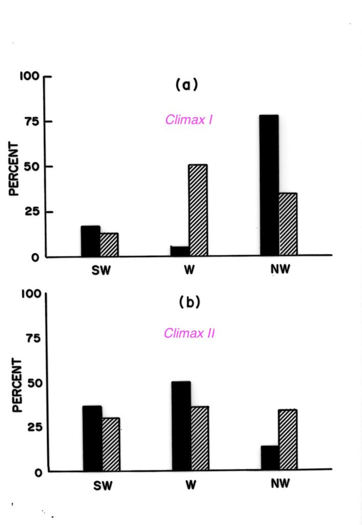

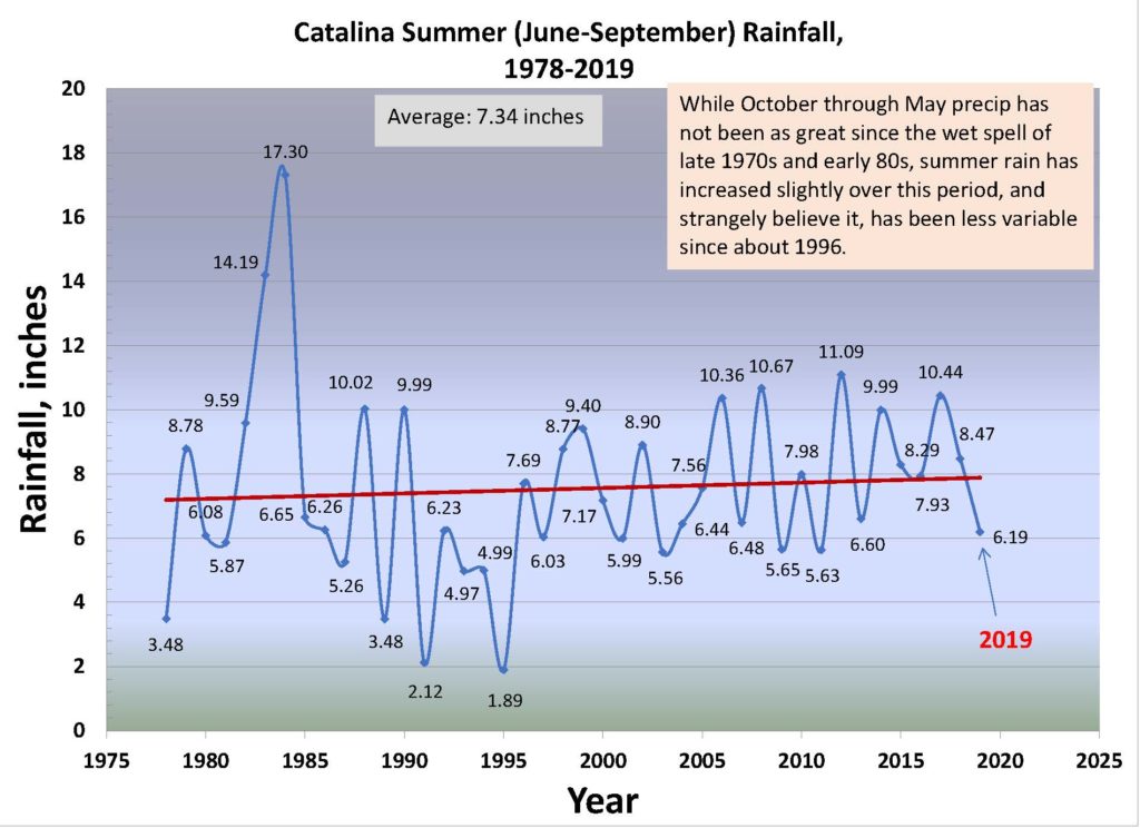
 Right out of Computer Shopper magazine, too! You can’t find deals like this today, that’s for sure.
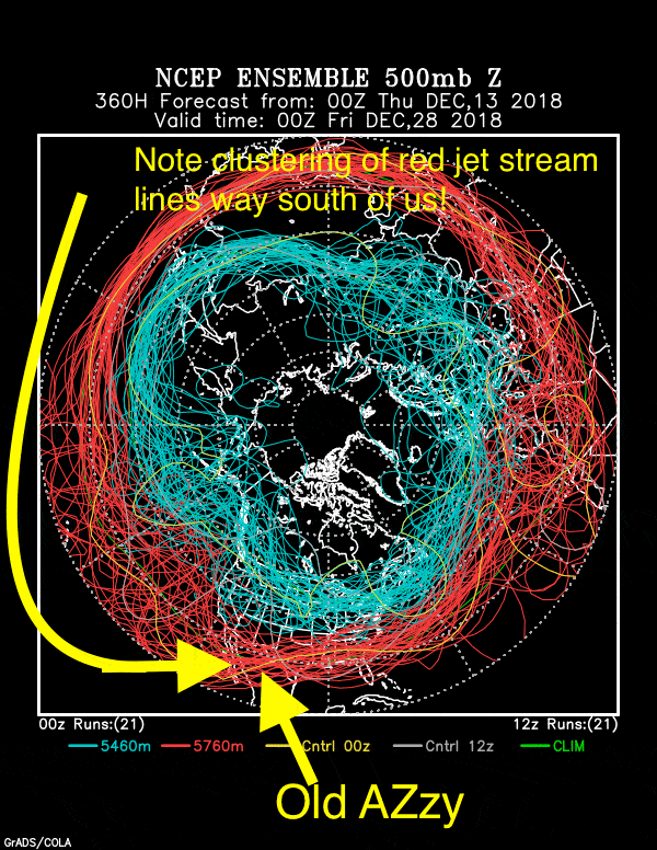
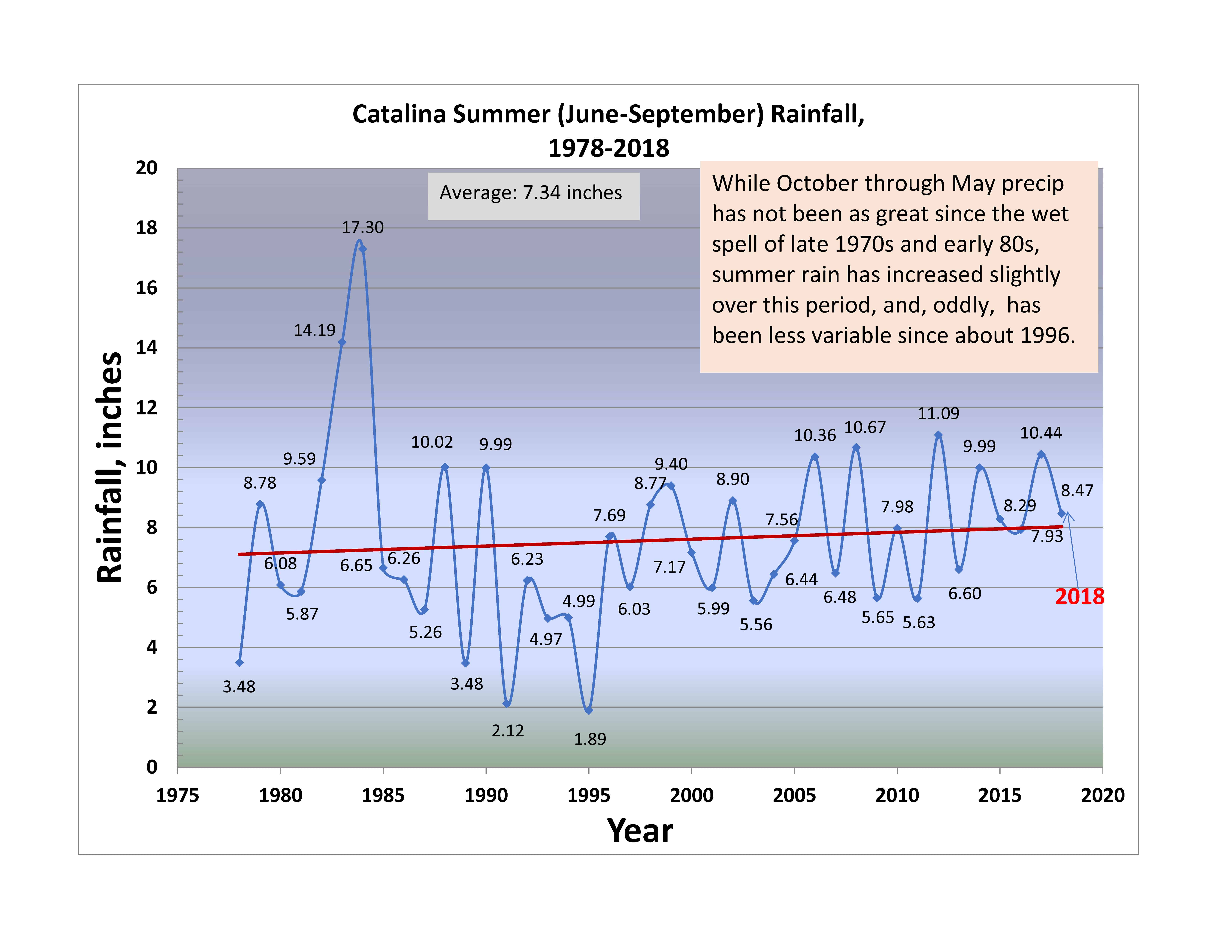
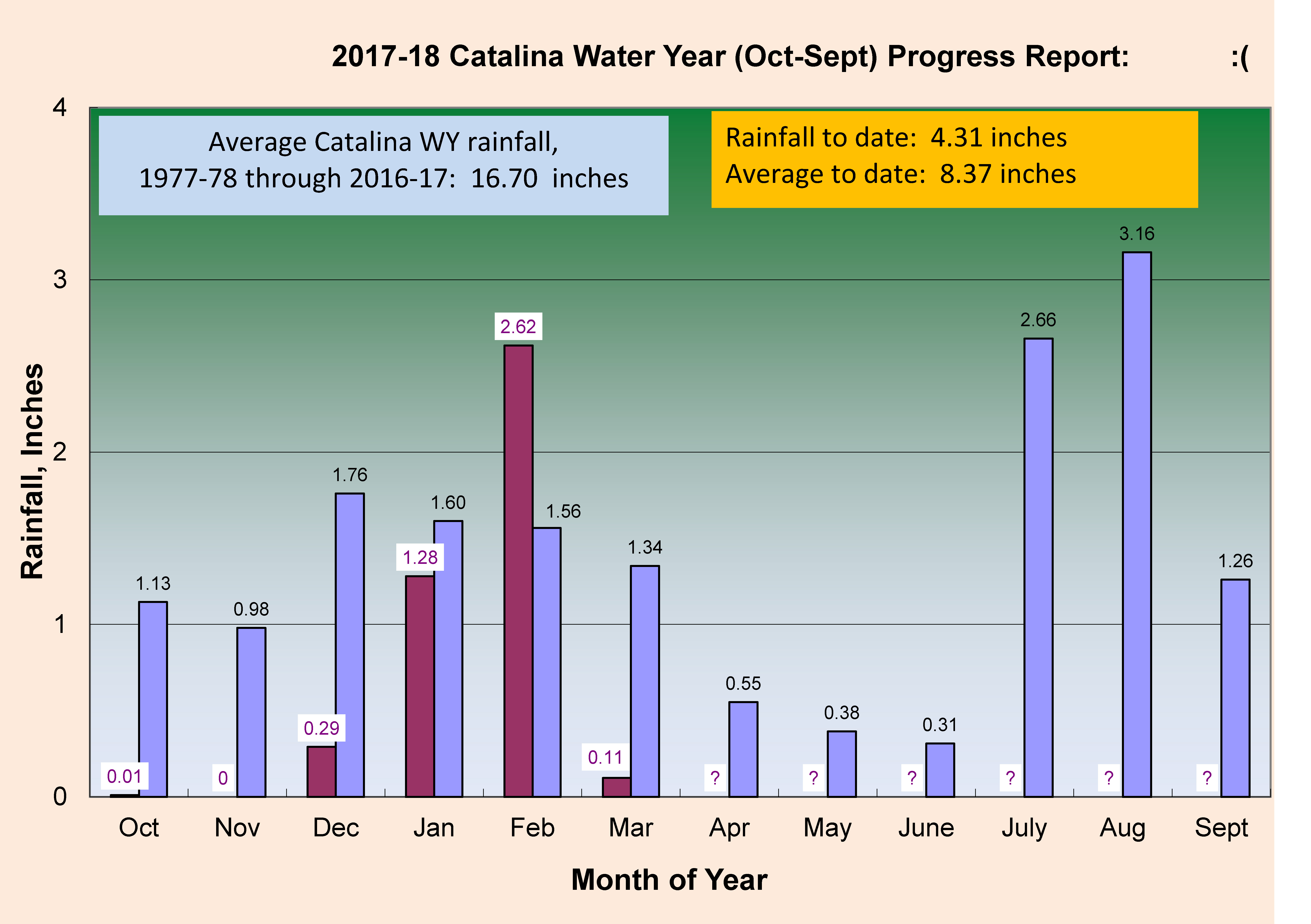